Brunei
From Wikipedia, the free encyclopedia
| Negara Brunei Darussalam State of Brunei, Abode of Peace بروني دارالسلام
|
||||||
|---|---|---|---|---|---|---|
|
||||||
| Motto: "Always in service with God's guidance" (translation) | ||||||
| Anthem: Allah Peliharakan Sultan God Bless the Sultan |
||||||
 |
||||||
| Capital (and largest city) |
Bandar Seri Begawan | |||||
| Official languages | Malay (Bahasa Brunei)[citation needed] | |||||
| Demonym | Bruneian | |||||
| Government | Islamic Absolute Monarchy | |||||
| - | Sultan | Hassanal Bolkiah | ||||
| - | Crown Prince | Al-Muhtadee Billah | ||||
| Formation | ||||||
| - | Sultanate | 14th century | ||||
| - | End of British protectorate |
January 1, 1984 | ||||
| Area | ||||||
| - | Total | 5,765 km2 (172nd) 2,226 sq mi |
||||
| - | Water (%) | 8.6 | ||||
| Population | ||||||
| - | July 2008 estimate | 381,371[1] | ||||
| - | Density | 66/km2 (134th) 168/sq mi |
||||
| GDP (PPP) | 2007 estimate | |||||
| - | Total | $19.640 billion (114th) | ||||
| - | Per capita | $51,000 (5th) | ||||
| HDI (2008) | ▲ 0.919 (high) (27th) | |||||
| Currency | Brunei dollar (BND) |
|||||
| Time zone | (UTC+8) | |||||
| Drives on the | left | |||||
| Internet TLD | .bn | |||||
| Calling code | +6731 | |||||
| 1 | Also 080 from East Malaysia | |||||

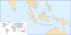
Brunei Darussalam, (pronounced /bruːˈnaɪ/ in English) officially the State of Brunei, Abode of Peace (Malay: Negara Brunei Darussalam, Jawi: بروني دارالسلام), is a country located on the north coast of the island of Borneo, in Southeast Asia. Apart from its coastline with the South China Sea it is completely surrounded by the state of Sarawak, Malaysia, and in fact it is separated into two parts by Limbang, which is part of Sarawak.
Brunei, the remnant of a very powerful sultanate, regained its independence from the United Kingdom on 1 January 1984.
Contents |
[edit] History
The power of the Sultanate of Brunei was at its peak from the fourteenth to the sixteenth century.[2] The Sultanate's suzerainty extended over the coastal regions of modern-day Sarawak and Sabah, the Sulu archipelago, and the islands off the northwest tip of Borneo. European influence gradually brought an end to this regional power. Later, there was a brief war with Spain, in which Brunei's capital was occupied. Eventually the sultanate was victorious but lost territories to Spain. The decline of the Bruneian Empire culminated in the nineteenth century when Brunei lost much of its territory to the White Rajahs of Sarawak, resulting in its current small landmass and separation into two parts. Brunei was a British protectorate from 1888 to 1984. Brunei was occupied by Japan from 1941 to 1945 during World War II
There was a small rebellion against the monarchy during the 1960s, which was suppressed by the United Kingdom. This event became known as the Brunei Revolt and was partly responsible for the failure to create the North Borneo Federation. The rebellion also affected Brunei's decision to opt out of the Malaysian Federation and was the first stage of the Indonesia-Malaysia confrontation.
[edit] Politics and government

Sultan Hassanal Bolkiah of Brunei, whose title has passed within the same dynasty since the fifteenth century, is the head of state and head of government in Brunei. Brunei has a Legislative Council with 20 appointed members, that only has consultative tasks.
Under Brunei's 1959 constitution, His Majesty Paduka Seri Baginda Sultan Haji Hassanal Bolkiah Mu'izzaddin Waddaulah, is the head of state with full executive authority, including emergency powers since 1962. The Sultan's role is enshrined in the national philosophy known as Melayu Islam Beraja (MIB), or Malay Islamic Monarchy. The country has been under hypothetical martial law since Brunei Revolt of 1962.
The media is extremely pro-government and the Royal family retains a venerated status within the country.
[edit] International organizations and Brunei
Brunei is a member of the United Nations, Commonwealth of Nations, ASEAN, APEC and Organization of the Islamic Conference.
[edit] Press freedom
Brunei has been given "Not Free" status by Freedom House; press criticism of the government and monarchy is rare.[3]
[edit] Territorial disputes
Brunei claims some terrorists in Sarawak and it is one of many nations to lay claim to some of the disputed Spratly Islands, specifically small rocks exposed at high tide on Louisa Reef. Kuraman Island is recognized as Malaysia territory by Brunei.
The status of Limbang as part of Sarawak was disputed by Brunei since the area was first annexed in 1890.[4]
[edit] Districts and mukims

Brunei is divided into four districts (daerah):
The districts are subdivided into thirty-eight mukims.
[edit] Geography

Brunei Darussalam consists of two unconnected parts with a total area of 5,766 sq. kilometers (2,226 sq. miles). 97% of the population lives in the larger western part, while only about 10,000 live in the mountainous eastern part (the district of Temburong). The total population of Brunei Darussalam is about 400,000 of which around 130,000 live in the capital Bandar Seri Begawan. Other major towns are the port town of Muara, the oil producing town of Seria and its neighboring town, Kuala Belait. In the Belait district, the Panaga area is home to large numbers of expatriates due to Royal Dutch Shell and British Army housing and recreational facilities. The well-known Panaga Club is situated here. Jerudong Park, a well known amusement park, is located on the west of Bandar Seri Begawan.
[edit] Climate
Brunei Darussalam has an equatorial climate. The average annual temperature is 27.1°C (80.8°F), with the April-May average of 27.7°C (81.9°F) and the October-December average of 26.8°C (80.2°F).
| Month | Jan | Feb | Mar | Apr | May | Jun | Jul | Aug | Sep | Oct | Nov | Dec | Year |
|---|---|---|---|---|---|---|---|---|---|---|---|---|---|
| Average High (°C) |
27.8 |
27.8 |
29.2 |
29.1 |
29.5 |
28.1 |
28.4 |
28.3 |
28.0 |
27.5 |
27.4 |
28.0 |
|
| Average Low (°C) |
25.1 |
26.0 |
26.5 |
26.9 |
26.9 |
26.7 |
26.1 |
26.3 |
26.3 |
26.1 |
26.2 |
25.6 |
|
| Average Rainfall (mm) | 277.7 | 138.3 | 113.0 | 200.3 | 239.0 | 214.2 | 228.8 | 215.8 | 257.7 | 319.9 | 329.4 | 343.5 |
|
[edit] Economy
This small, wealthy economy is a mixture of foreign and domestic entrepreneurship, government regulation, welfare measures, and village tradition. Crude oil and natural gas production account for nearly half of its GDP. Substantial income from overseas investment supplements income from domestic production. The government provides for all medical services and subsidizes rice and housing. Brunei's leaders are concerned that steadily increased integration in the world economy will undermine internal social cohesion although it became a more prominent player by serving as chairman for the 2000 Asia-Pacific Economic Cooperation (APEC) forum. Stated plans for the future include upgrading the labour force, reducing unemployment, strengthening the banking and tourism sectors, and, in general, further widening the economic base. The national airline, Royal Brunei, is trying to make Brunei a hub for international travel between Europe and Australia/New Zealand, and also has services to major Asian destinations.
[edit] Healthcare
All Brunei citizens have access to free healthcare from public hospitals. The largest hospital in Brunei is Raja Isteri Pengiran Anak Saleha Hospital, and there is a private medical centre, the Jerudong Park Medical Centre. As of 2008, no hospitals in Brunei were undergoing international healthcare accreditation.
There is currently no medical school in Brunei, and Bruneians wishing to study to become doctors have to attend universities overseas. However, there has been a School of Nursing since 1951.[5]
[edit] Transport
Brunei is accessible via sea and land travel. The main highway running across Brunei is the Pan Borneo Highway, which is a joint project with Malaysia. Besides the Pan Borneo Highway, Brunei can be accessed by air through Brunei International Airport. Royal Brunei is the main airline company in Brunei.
Brunei has several sea ports, mainly to export its petroleum products, as well as for import and export purposes.
[edit] Ethnicity
[edit] Demographics

The official language of the nation is Malay (Malay: Bahasa Melayu), although an important minority speak Chinese languages (Min Nan, Mandarin, Min Dong, Yue, Hakka). The local variety of Malay (Kedayan or Bukit Malay), spoken natively by two thirds of the population, is quite divergent from and unintelligible to Standard Malay. The most important aboriginal languages are Iban, and two languages called Tutong, each with about 20,000 speakers. English is also widely spoken and there is a relatively large expatriate community with significant numbers of British and Australian citizens.
Islam is the official religion of Brunei at 67%, and the sultan is the head of the religion in the country. Other faiths practised are Buddhism 13% (mainly by the Chinese), 10% Christianity, and primarily in isolated and very small communities, indigenous religions.
[edit] Culture
The culture of Brunei is predominantly Malay (reflecting its ethnicity), with heavy influences from Islam, but is seen as more conservative than Malaysia.[7]
Brunei also has a large number of foreign workers, including Indonesian and Filipino domestic workers, labourers from Thailand, Indonesia and the Indian subcontinent (particularly India and Bangladesh), and American and British professionals working in industry and education.
[edit] Prohibition of alcohol
The sale and public consumption of alcohol is banned.[8] Foreigners and non-Muslims are allowed to bring in 12 cans of beer and 2 bottles of other alcohol (e.g., wine or spirits; no distinction is made for alcohol content). This limit used to apply to every entry; in 2007, however, this was changed to one limit every 48 hours. After the introduction of prohibition in the early 1990s, all pubs and nightclubs were forced to close.
[edit] Bruneian celebrities
- Wu Chun, member of Fahrenheit
- Zul F, winner of 2005 Brunei Idol
- Paula Malai Ali, television presenter for ESPN Star Sports
- Maria, country female singer
- Craig Adams, professional ice hockey player for the Pittsburgh Penguins of the NHL
[edit] See also
|
|
[edit] Notes and references
- ^ CIA - The World Factbook: Brunei
- ^ "Background Note: Brunei Darussalam". US State Department. http://www.state.gov/r/pa/ei/bgn/2700.htm. Retrieved on 2008-12-16.
- ^ http://www.freedomhouse.org/inc/content/pubs/pfs/inc_country_detail.cfm?country=6929&year=2007&pf
- ^ the CIA World Fact Book
- ^ FHA - [Nursing staff education in Brunei - Article Summary
- ^ CIA - The World Factbook -- Brunei
- ^ For a discussion of religious freedom, see http://www.state.gov/g/drl/rls/irf/2006/71334.htm (United States Department of State).
- ^ Brunei Tourism Website (Government appointed)
[edit] Bibliography
![]() This article contains material from the CIA World Factbook which, as a U.S. government publication, is in the public domain.
This article contains material from the CIA World Factbook which, as a U.S. government publication, is in the public domain.
- U.S. Department of State website (2003)
- L. W. W. Gudgeon, British North Borneo, Adam and Charles Black: London, 1913.
[edit] External links
![]() Textbooks from Wikibooks
Textbooks from Wikibooks
![]() Quotations from Wikiquote
Quotations from Wikiquote
![]() Source texts from Wikisource
Source texts from Wikisource
![]() Images and media from Commons
Images and media from Commons
![]() News stories from Wikinews
News stories from Wikinews
| Wikimedia Commons has media related to: Brunei |
- Government
- General information
- Brunei entry at The World Factbook
- Brunei from UCB Libraries GovPubs
- Brunei at the Open Directory Project
- Wikimedia Atlas of Brunei
- Travel
- Brunei travel guide from Wikitravel
- Brunei Tourism website
- The Daily Brunei Resources blog. Contains extra information on the country through the eyes of a Bruneian.
- Brunei information on globalEDGE
- Photos of Brunei
|
||||||||||||||||||||||||||||||||||||||||||||||||||||||||||||||||||||||||||||||||||||||||||||||||||||


