Easter Island
From Wikipedia, the free encyclopedia
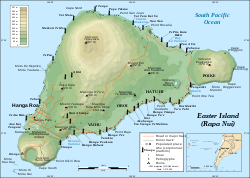
| Easter Island Isla de Pascua Rapa Nui
|
||||
|---|---|---|---|---|
|
||||
 |
||||
| Capital | Hanga Roa |
|||
| Official languages | Spanish, Rapa Nui[citation needed] | |||
| Ethnic groups (2001) | Rapanui 60%, European or Mestizo 39%, Amerindian 1% | |||
| Demonym | Rapa Nui or Pascuense | |||
| Government | Special territory of Chile[1] | |||
| - | President of Chile | Michelle Bachelet | ||
| - | Regional Intendant | Iván de la Maza | ||
| - | Provincial Governor | Melania Carolina Hotu Hey | ||
| - | Mayor | Pedro Pablo Edmunds Paoa | ||
| Annexation | to Chile | |||
| - | Treaty signed | September 9, 1888 | ||
| Area | ||||
| - | Total | 163.6 km2 63.1 sq mi |
||
| Population | ||||
| - | 2002 census | 3,791 | ||
| - | Density | 23.17/km2 60.08/sq mi |
||
| Currency | Peso (CLP) |
|||
| Time zone | Central Time Zone (UTC-6) | |||
| Internet TLD | .cl | |||
| Calling code | 56 32 | |||

Easter Island (Rapa Nui: Rapa Nui, Spanish: Isla de Pascua) is a Polynesian island in the southeastern Pacific Ocean, at the southeastern most point of the Polynesian triangle. The island is a special territory of Chile. Easter Island is famous for its monumental statues, called moai (IPA: /ˈmoʊ.аɪ/), created by the Rapanui people. It is a world heritage site with much of the island protected within the Rapa Nui National Park.
Contents |
[edit] Name
The name "Easter Island" was given by the island's first recorded European visitor, the Dutch explorer Jacob Roggeveen, who encountered it on Easter Sunday 1722, while searching for Davis or David's island and gave it the name Paasch-Eyland (17th century Dutch for "Easter Island").[2] The island's official Spanish name, Isla de Pascua, is also Spanish for "Easter Island".
The current Polynesian name of the island, "Rapa Nui" or "Big Rapa", was coined by labor immigrants from Rapa in the Bass Islands, who likened it to their home island in the aftermath of the Peruvian slave deportations in the 1870s.[3] However, Thor Heyerdahl has claimed that the naming would have been the opposite, Rapa being the original name of Easter Island, and Rapa Iti was named by its refugees.[4]
There are several hypotheses about the "original" Polynesian name for Easter Island, including Te pito o te henua, or "The Navel of the World" due to its isolation. Legends claim that the island was first named as Te pito o te kainga a Hau Maka, or the "Little piece of land of Hau Maka".[5] Another name, Mata-ki-Te-rangi, means "Eyes that talk to the sky."[6]
[edit] Location and physical geography


Easter Island is one of the world's most isolated inhabited islands. It is 3,600 km (2,237 mi) west of continental Chile and 2,075 km (1,290 mi) east of Pitcairn (Sala y Gómez, 415 kilometres to the east, is closer but uninhabited).
It has a latitude close to that of Caldera, Chile, an area of 163.6 km² (63 sq mi), and a maximum altitude of 507 metres. There are three Rano (freshwater crater lakes), at Rano Kau, Rano Raraku and Rano Aroi, near the summit of Terevaka, but no permanent streams or rivers.
[edit] Climate and weather in Easter Island
The island's climate is subtropical marine. The lowest temperatures are registered in July and August (18°C - 64°F) and the highest temperatures in February, which corresponds to the summer season in the southern hemisphere. The rainiest month is April, though the island experiences year-round rainfall.[7]
[edit] Geology
Easter Island is a volcanic high island, consisting mainly of three extinct volcanoes: Terevaka (altitude 507 metres) forms the bulk of the island. Two other volcanoes, Poike and Rano Kau, form the eastern and southern headlands and give the island its approximately triangular shape. There are numerous lesser cones and other volcanic features, including the crater Rano Raraku, the cinder cone Puna Pau and many volcanic caves including lava tubes. Poike used to be an island until volcanic material from Terevaka united it to Easter Island. The island is dominated by hawaiite and basalt flows which are rich in iron and shows affinity with igneous rocks found in Galapagos Islands.[1]
Easter Island and surrounding islets such as Motu Nui, Motu Iti are the summit of a large volcanic mountain which rises over two thousand metres from the sea bed. It is part of the Sala y Gómez Ridge, a (mostly submarine) mountain range with dozens of seamounts starting with Pukao and then Moai, two seamounts to the west of Easter Island, and extending 2,700 km (1,700 mi) east to the Nazca Seamount.[8]
Pukao, Moai and Easter Island were formed in the last 750,000 years, with the most recent eruption a little over a hundred thousand years ago. They are the youngest mountains of the Sala y Gómez Ridge, which has been formed by the Nazca Plate floating over the Easter hotspot.[9] Only at Easter Island, its surrounding islets and Sala y Gómez does the Sala y Gómez Ridge form dry land.
In the first half of the 20th century, steam came out of the Rano Kau crater wall. This was photographed by the island's manager, Mr Edmunds.[2]
[edit] History
| Rapa Nui National Park* | |
|---|---|
| UNESCO World Heritage Site | |
 |
|
| State Party | |
| Type | Cultural |
| Criteria | i, iii, v |
| Reference | 715 |
| Region** | Oceanic Continent |
| Inscription history | |
| Inscription | 1995 (19th Session) |
| * Name as inscribed on World Heritage List. ** Region as classified by UNESCO. |
|
The history of Easter Island is rich and controversial. Its inhabitants have endured famines, epidemics, civil war, slave raids and colonialism, and the crash of their ecosystem; their population has declined precipitously more than once. They have left a cultural legacy that has brought them fame disproportionate to their population.
Contemporary to the arrival of the first settlers of Hawaii, 300-400 CE was published as a date for initial settlement of Easter Island. Although some scholars argue for initial settlement of 700-800 CE, there is an on-going study by archaeologists Terry Hunt and Carl Lipo that states: “Radiocarbon dates for the earliest stratigraphic layers at Anakena, Easter Island, and analysis of previous radiocarbon dates imply that the island was colonized late, about 1200 CE. Significant ecological impacts and major cultural investments in monumental architecture and statuary thus began soon after initial settlement.”[10]
The island was populated by Polynesians who navigated in canoes or catamarans from the Marquises islands (3200 km, away) or Tuamotou islands (Mangareva, 2600 km away) or Pitcairn (2000 km, away). When Captain Cook visited the island, one of his crew members, who was a Polynesian from Bora Bora, was able to communicate with the Rapa Nui. In 1999, a reconstitution with Polynesian boats was carried out, reaching Easter Island from Mangareva in 17 days.[citation needed]
According to legends recorded by the missionaries in the 1860s, the island originally had a very clear class system, with an ariki, king, wielding absolute god-like power ever since Hotu Matu'a had arrived on the island. The most visible element in the culture was production of massive moai that were part of the ancestral worship. With a strictly unified appearance, moai were erected along most of the coastline, indicating a homogeneous culture and centralized governance.
For unknown reasons, a coup by military leaders called matatoa had brought a new cult based around a previously unexceptional god Makemake. The cult of the birdman (Rapanui: tangata manu) was largely to blame for the island's misery of the late 18th and 19th centuries. With the island's ecosystem fading, destruction of crops quickly resulted in famine, sickness and death.
European accounts from 1722 and 1770 still saw only standing statues, but by Cook's visit in 1774 many were reported toppled. The huri mo'ai - the "statue-toppling" - continued into the 1830s as a part of fierce internecine wars. By 1838 the only standing Moai were on the slopes of Rano Raraku and Hoa Hakananai'a at Orongo.
The first recorded European contact with the island was on April 5 (Easter Sunday) 1722 when Dutch navigator Jacob Roggeveen visited for a week and estimated there were 2,000 to 3,000 inhabitants on the island. The next foreign visitors (on November 15, 1770) were two Spanish ships, San Lorenzo and Santa Rosalia. They reported the island as largely uncultivated, with a seashore lined with stone statues. Four years later, in 1774, British explorer James Cook visited Easter Island, he reported the statues as being neglected with some having fallen down. In 1825, the British ship, HMS Blossom, visited and reported no standing statues. Easter Island was approached many times during the 19th century, but by now the islanders had become openly hostile towards any attempt to land, and very little new information was reported before the 1860s.

A series of devastating events killed or removed almost the entire population of Easter Island in the 1860s. In December 1862, Peruvian slave raiders struck Easter Island. Violent abductions continued for several months, eventually capturing or killing around 1500 men and women, about half of the island's population. A dozen islanders managed to return from their slavery, but brought with them smallpox and started an epidemic, which reduced the island's population to the point where some of the dead were not even buried. Contributing to the chaos were violent clan wars with the remaining people fighting over the newly available lands of the deceased, bringing further famine and death among the dwindling population. The first Christian missionary, Eugène Eyraud, brought tuberculosis to the island in 1867 which took a quarter of the island's remaining population of 1,200.
Jean-Baptiste Dutrou-Bornier bought up all of the island apart from the missionaries' area around Hanga Roa and moved a couple of hundred Rapanui to Tahiti to work for his backers. In 1871 the missionaries, having fallen out with Dutrou-Bornier, evacuated all but 171 Rapanui to the Gambier islands.[11] Those who remained were mostly older men. Six years later, there were just 111 people living on Easter Island, and only 36 of them had any offspring.[12]

From that point on and into the present day, the island's population slowly recovered. But with over 97% of the population dead or having left in less than a decade, much of the island's cultural knowledge had been lost.
Easter Island was annexed by Chile on September 9, 1888, by Policarpo Toro, by means of the "Treaty of Annexation of the island" (Tratado de Anexión de la isla), that the government of Chile signed with the Rapanui people.
Until the 1960s, the surviving Rapanui were confined to the settlement of Hanga Roa and the rest of the island was rented to the Williamson-Balfour Company as a sheep farm until 1953.[13] The island was then managed by the Chilean Navy until 1966 and at that point the rest of the island was reopened. In 1966, the Rapanui were given Chilean citizenship.[14]
On July 30, 2007, a constitutional reform gave Easter Island and Juan Fernández Islands the status of special territories of Chile. Pending the enactment of a special charter, the island will continue to be governed as a province of the Valparaíso Region.[15]
[edit] Ecology

Easter Island, together with its closest neighbour, the tiny island of Isla Sala y Gómez 415 kilometres (258 mi) further east, is recognized by ecologists as a distinct ecoregion, the Rapa Nui subtropical broadleaf forests. Having relatively little rainfall contributed to eventual deforestation. The original subtropical moist broadleaf forests are now gone, but paleobotanical studies of fossil pollen and tree moulds left by lava flows indicate that the island was formerly forested, with a range of trees, shrubs, ferns, and grasses. A large now extinct palm, Paschalococos disperta, related to the Chilean wine palm (Jubaea chilensis), was one of the dominant trees as attested by fossil evidence; human overpopulation in the period 1200 to 350 years before present led to deforestation of this palm and its resultant extinction.[16] The toromiro tree (Sophora toromiro) was prehistorically present on Easter Island, and is now extinct in the wild. However, the Royal Botanic Gardens, Kew, and the Göteborg Botanical Garden are jointly leading a scientific program to reintroduce the toromiro to Easter Island. The island is, and has been for at least the last three centuries, mainly covered in grassland with nga'atu or bulrush (Schoenoplectus californicus tatora) in the crater lakes of Rano Raraku and Rano Kau. The presence of these reeds, which are called totora in the Andes, was used to support the argument of a South American origin of the statue builders, but pollen analysis of lake sediments shows these reeds have grown on the island for over 30,000 years. Before the arrival of humans, Easter Island had vast seabird colonies, no longer found on the main island, and there is fossil evidence for five species of landbirds, which have become extinct.[17]
[edit] Destruction of the ecosystem
"The overall picture for Easter is the most extreme example of forest destruction in the Pacific, and among the most extreme in the world: the whole forest gone, and all of its tree species extinct."[18]

Trees are sparse on modern Easter Island, rarely forming small groves. The island once had a forest of palms, and it has been argued that native Easter Islanders deforested the island in the process of erecting their statues,[19] and in providing sustenance for an overpopulated island.[citation needed] Experimental archaeology has demonstrated that some statues certainly could have been placed on "Y" shaped wooden frames called miro manga erua and then pulled to their final destinations on ceremonial sites.[19] Other theories involve the use of "ladders" (parallel wooden rails) over which the statues could have been dragged.[18] Rapanui traditions metaphorically refer to spiritual power (mana) as the means by which the moai were "walked" from the quarry. But, given the island's southern latitude, the climatic effects of the Little Ice Age (about 1650 to 1850) may have exacerbated deforestation, though such speculation is unproven.[19]
Jared Diamond dismisses past climate change as a dominant factor on the island's deforestation in his book Collapse which presents an extensive look into the collapse of the ancient Easter Islanders. Diamond argues that the disappearance of the island's trees seems to coincide with a decline of its civilization around the 17th and 18th century. Midden contents show a sudden drop in quantities of fish and bird bones as the islanders lost the means to construct fishing vessels and the birds lost their nesting sites. Soil erosion due to lack of trees is apparent in some places. Sediment samples document that up to half of the native plants had become extinct and that the vegetation of the island was drastically altered. Chickens and rats became leading items of diet and there are contested hints that cannibalism occurred, based on human remains associated with cooking sites, especially in caves.

In his article "From Genocide to Ecocide: The Rape of Rapa Nui", Benny Peiser notes evidence of self-sufficiency on Easter Island when Europeans first arrived. Although stressed, the island may still have had some (small) trees, mainly toromiro. Cornelis Bouman, Jakob Roggeveen's captain, stated in his log book, "... of yams, bananas and small coconut palms we saw little and no other trees or crops." According to Carl Friedrich Behrens, Roggeveen's officer, "The natives presented palm branches as peace offerings. Their houses were set up on wooden stakes, daubed over with luting and covered with palm leaves," (presumably from banana plants as the island was by then deforested). The stakes indicate that either driftwood or living trees were still available, though the reliability of Behrens as a source is questionable[citation needed]. By contrast, Peiser considers these reports to indicate that considerable numbers of large trees still existed at that time, which is explicitly contradicted by the Bouman quote above.
In his book A Short History of Progress, Ronald Wright speculates that for a generation or so, "there was enough old lumber to haul the great stones and still keep a few canoes seaworthy for deep water". When the day came that the last boat was gone, wars broke out over "ancient planks and wormeaten bits of jetsam". But this statement is flawed since the sea going craft the islanders used were not made of wood, but of bundles of freshwater reeds planted in the Rano Kao crater which, according to Wright, were planted by one of the first "long-ear" settlers. A one-man craft of bound nga'atu was called a pora. There were larger reed ships, some containing three masts with reed sails and capable of holding over 400 individuals, and are depicted in petroglyphs, roof paintings and sculptures.
By the end of the third epoch in the island's history, with only one "long-ear" surviving, there were more than a thousand moai (stone statues), which was one for every ten islanders (Wright, 2004). When the Europeans arrived in the 18th century, the worst was over and they only found one or two living souls per statue.
Easter Island has suffered from heavy soil erosion in recent centuries, perhaps aggravated by agriculture and massive deforestation. This process seems to have been gradual and may have been aggravated by extensive sheep farming of the Williamson-Balfour Company throughout most of the 20th century. Jakob Roggeveen reported that Easter Island was exceptionally fertile. "Fowls are the only animals they keep. They cultivate bananas, sugar cane, and above all sweet potatoes." In 1786 M. de La Pérouse visited Easter Island and his gardener declared that "three days' work a year" would be enough to support the population.
Rollin, a major in the Perouse expedition of 1786, wrote, "Instead of meeting with men exhausted by famine... I found, on the contrary, a considerable population, with more beauty and grace than I afterwards met in any other island; and a soil, which, with very little labour, furnished excellent provisions, and in an abundance more than sufficient for the consumption of the inhabitants."[20]
That oral traditions of the islanders are obsessed with cannibalism is sometimes taken as evidence supporting a rapid collapse. For example, to severely insult an enemy one would say, "The flesh of your mother sticks between my teeth." Diamond suggests that this means the food supply of the people ultimately ran out;[21] however, cannibalism was widespread across Polynesian cultures, rendering his conclusion speculative.[22]
[edit] Culture

[edit] Mythology
|
|
This section does not cite any references or sources. Please help improve this article by adding citations to reliable sources (ideally, using inline citations). Unsourced material may be challenged and removed. (June 2008) |
The most important myths are:
- Tangata manu, the Birdman cult which was practiced until the 1860s.
- Makemake, an important god.
- Aku-aku, the guardians of the sacred family caves.
- Moai-kava-kava a ghost man of the Hanau epe (long-ears.)
- Hekai ite umu pare haonga takapu Hanau epe kai noruego, the sacred chant to appease the aku-aku before entering a family cave.
[edit] Stone work
Rapa Nui is a volcanic island consisting of geologically recent igneous rock. The Rapa Nui people had a Stone Age civilization and made extensive use of several different types of indigenous stone:
- Basalt, a hard, dense stone used for toki and at least one of the moai.
- Obsidian, a volcanic glass with sharp edges used for sharp-edged implements such as Mataa and also for the black pupils of the eyes of the moai.
- Red Scoria from Puna Pau, a very light red stone used for the pukao and a few moai.
- Tuff from Rano Raraku, a much more easily worked rock than basalt, and was used for most of the moai.
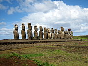
[edit] Moai (statues)

The large stone statues, or moai, for which Easter Island is world-famous, were carved during a relatively short and intense burst of creative and productive megalithic activity. A total of 887 monolithic stone statues have been inventoried on the island and in museum collections.[23] Although often identified as "Easter Island heads", the statues are actually complete torsos, the figures kneeling on bent knees with their hands over their stomach. Some upright moai have become buried up to their necks by shifting soils.
The period when the statues were produced remains disputed, with estimates ranging from 400 CE to 1500–1700 CE. Almost all (95%) moais were carved out of distinctive, compressed, easily worked volcanic ash or tuff found at a single site inside the extinct volcano Rano Raraku. The native islanders who carved them used only stone hand chisels, mainly basalt toki, which still lie in place all over the quarry. The stone chisels were re-sharpened by chipping off a new edge when dulled. The volcanic stone the moai were carved from was first wetted to soften it before sculpting began, then again periodically during the process. While many teams worked on different statues at the same time, a single moai would take a team of five or six men approximately one year to complete. Each statue represents a deceased long-ear chief or important person, their body interred within the ahu, or coastal platforms, the moai stand upon.

Only a quarter of the statues were installed, while nearly half still remain in the quarry at Rano Raraku and the rest elsewhere on the island, probably on their way to final locations. The largest Moai is known as "Paro" weighing 82 tons.[24] There are several others close to this size. Moving the huge statues required a miro manga erua, a Y-shaped sledge with cross pieces, pulled with ropes made from the tough bark of the hau-hau tree,[25] and tied fast around the statue's neck. Anywhere from 180 to 250 men were required for pulling, depending on the size of the moai. Some 50 of the now standing statues have been re-erected in modern times. The first moai was re-erected on the beach of Anakena in 1958 using traditional methods during an expedition to the island by Thor Heyerdahl.
While the vast majority of moai follow a fairly standard design, a few are radically different, in most parts badly eroded and broken. These are believed to predate the better-known moai, including a kneeling statue with hands on its knees, parts of a statue with clearly carved ribs and a headless, rectangularly shaped torso. Similarities to Indian stone statues around Lake Titicaca in South America are striking, whether this is accidental or not.[26]
[edit] Ahu

Ahu are stone platforms which vary greatly in layout. Many have been significantly reworked during or after the huri mo'ai or statue-toppling era; many became ossuaries; one was dynamited open; and Ahu Tongariki was swept inland by a tsunami. Of the 313 known ahu, 125 carried stone moai—usually just one, probably due to the shortness of the moai period and difficulties in transporting them. Ahu Tongariki, one kilometer from Rano Raraku, had the most and tallest moai, 15 in total. Other notable ahu with moai are Ahu Akivi, restored in 1960 by William Mulloy, Nau Nau at Anakena and Tahai. Ahu without stone moai may have had statues made of wood, now lost.
The classic elements of ahu design are:
- A retaining rear wall several feet high, usually facing the sea.
- A platform behind the wall.
- Pads or cushions on the platform.
- A sloping ramp covered with evenly sized, wave-rounded boulders on the inland side of the platform rising most of, but not all, the way up the side of the platform.
- A pavement in front of the ramp.
- Inside the Ahu was a fill of rubble.

On top of many Ahu would have been:
- Moai on the pads looking out over the pavement with their backs to the rear wall.
- Pukao on the moai's heads.
- And in their eye sockets, white coral eyes with black obsidian pupils.
Ahu evolved from the traditional Polynesian marae in which the word ahu was only used for the central stone platform, though on Easter Island ahu and moai evolved to a much greater size. The biggest ahu contained 20 times as much stone as a moai; however, most of this stone was sourced very locally (apart from broken, old moai, fragments of which have also been used in the fill).[27] Also individual stones are mostly far smaller than the moai, so less work was needed to transport the raw material.
Ahu are found mostly on the coast, where they are distributed fairly evenly except on the western slopes of Mount Terevaka and the Rano Kau and Poike[28] headlands. These are the three areas with the least low-lying coastal land, and apart from Poike the furthest areas from Rano Raraku. One ahu with several moai was recorded on the cliffs at Rano Kau in the 1880s, but had fallen to the beach by the time of the Routledge expedition in 1914.
[edit] Stone walls
One of the highest-quality examples of Easter Island stone masonry is the rear wall of the Ahu at Vinapu. Made without mortar by shaping hard basalt rocks of up to seven tons to match each other exactly, it has a superficial similarity to some Inca stone walls in South America.[29]
[edit] Stone houses
Some 1,233 prehistoric stone "houses", called tupa in earlier times[30] and hare moa ("chicken house") later, are more conspicuous than the remains of the prehistoric human houses which only had stone foundations (except for those at Orongo). Stone houses were up to 6 meters long, with a distinctive boat-shaped structure combined with a stick and palm leaf or thatch superstructure. The entrances were very low, and getting in required crawling.
Germans excavated some of the Hare Moa in 1882 and found human remains inside. Locals told them that they were resting places for the ariki, Easter Island kings and chiefs. Each house had two small holes—if a hostile spirit entered through one, the spirit of the deceased could escape through the other. As such and also by their old name, the stone houses are seen similar to Indian chullpas in Peru and Bolivia.[31] Noteworthy is that the remaining numbers of the stone houses and moais are quite close to each other, possibly meaning that for each person buried in a stone house, a moai was immediately constructed. Usage of stone houses as graves seems to have ceased around the same time when production of moais ended and ancestral worship declined. During the turmoils of the late 18th century, the islanders seem to have started to bury their dead among the ruined ahus—the moai platforms—and use the stone houses as chicken shelters. There are no human remains in them any more.
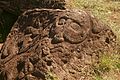
[edit] Petroglyphs
Petroglyphs are pictures carved into rock, and Easter Island has one of the richest collections in all Polynesia. Around 1,000 sites with more than 4,000 petroglyphs are catalogued. Designs and images were carved out of rock for a variety of reasons: to create totems, to mark territory or to memorialize a person or event. There are distinct variations around the island in terms of the frequency of particular themes among petroglyphs, with a concentration of Birdmen at Orongo. Other subjects include sea turtles, Komari (vulvas) and Makemake, the chief god of the Tangata manu or Birdman cult. (Lee 1992)
Petroglyphs are also common in the Marquesas islands.
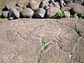 Fish petroglyph found near Ahu Tongariki |

[edit] Caves
The island and neighbouring Motu Nui are riddled with caves, many of which show signs of past human use and fortification, including narrowed entrances and crawl spaces with ambush points. Many caves feature in the myths and legends of the Rapa Nui.
[edit] Rongorongo
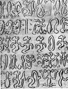
The undeciphered Easter island script rongorongo may be one of the very few writing systems created ex nihilo, without outside influence. Alternatively, the islanders' brief exposure to Western writing during the Spanish visit in 1770 may have inspired the ruling class to establish rongorongo as a religious tool.[32] Rongorongo has few similarities to the petroglyph corpus;[33] and there is not a single line of rongorongo carved in stone despite thousands of petroglyphs and other stonework.
Rongorongo was first reported by a French missionary, Eugène Eyraud, in 1864. At that time, several islanders claimed to be able to understand the writing, but all attempts to read them were unsuccessful. According to tradition, only a small part of the population was ever literate, rongorongo being a privilege of the ruling families and priests. This contributed to the total loss of knowledge of how to read rongorongo in the 1860s, when the island's elite was annihilated by slave raids and disease.
Of the hundreds of wooden tablets and staffs reportedly having rongorongo writing carved on them, only two dozen survive, scattered in museums around the world with none remaining on Easter Island. Decades of numerous attempts to decipher them have proved unfruitful, and the academic community does not agree on whether rongorongo was truly a form of writing.
[edit] Wood carving
Wood was scarce on Easter Island during the 18th and 19th centuries, but a number of highly detailed and distinctive carvings have found their way to the world's museums. Particular forms include:[34]
- Reimiro, a gorget or breast ornament of crescent shape with a head at one or both tips.[35] The same design appears on the flag of Rapa Nui. Two Rei Miru at the British Museum are inscribed with Rongorongo.
- Moko Miro, a man with a lizard head.
- Moai kavakava, grotesque and highly detailed human figures carved from Toromiro pine and represent deceased ancestors. The earlier figures are rare and generally depict a male figure with an emaciated body and a goatee. The figures' ribs and vertebrae are exposed and many examples show carved glyphs on various parts of the body but more generally, on the top of the head. The female figures, which are far rarer then the males are, depict the body as flat and often the female's hand lying across the body. The figures, although some quit large, were worn as ornamental pieces around a tribesman's neck, the more figures worn, the more important the man. The figures have a shiny surface, this patina developed from constant handling and contact with human skin.[citation needed]
- Ao, a large dancing paddle.
[edit] Contemporary culture

The Rapanui have:
- An annual cultural festival, the Tapati, held since 1975 around the beginning of February to celebrate Rapanui culture.
- A national football team.
- Three discos in the town of Hanga Roa.
- A musical tradition that combines South American and Polynesian influences (see music of Easter Island).
- A vibrant carving tradition.
[edit] Demography
[edit] 2002 census
Population at the 2002 census was 3,791 (3,304 in Hanga Roa alone). 60% were Rapanui, Chileans of European or mestizo descent were 39% of the population, and the remaining 1% were Native Americans from mainland Chile.
Rapanui have also migrated out of the island. At the 2002 census, 2,269 Rapanui lived on Easter Island, while 2,378 lived in the mainland of Chile (half of them in the metropolitan area of Santiago).[citation needed]
Population density on Easter Island is only 23 inhabitants per km² (60 per sq mi), much lower than in the 17th century heyday of the moai building when there were possibly as many as 15,000 inhabitants, or roughly 92 inhabitants per km² (214 per sq mi).
[edit] Demographic history

The population was 1,936 inhabitants in 1982. This increase in population is partly due to the arrival of people of European or mestizo descent from the mainland of Chile. Consequently, the island is losing its native Polynesian identity.[citation needed] In 1982 around 70% of the population were Rapanui (the native Polynesian inhabitants). Population had already declined to only 2,000–3,000 inhabitants before the slave raids of 1862. In the 19th century, disease due to contacts with Europeans, as well as deportation of 2,000 Rapanui to work as slaves in Peru, and the forced departure of the remaining Rapanui to Chile, carried the population of Easter Island to the all-time low of 111 inhabitants in 1877. Out of these 111 Rapanui, only 36 had descendants, but all of today's Rapanui claim descent from those 36.
[edit] Administration and legal status
Easter Island shares with Juan Fernández Islands the sui generis constitutional status of special territory of Chile, granted in 2007. A special charter for the island is currently being discussed, therefore it continues to be considered a province of the Valparaíso Region, containing a single commune. Both the province and the commune are called "Easter Island" and encompass the whole island and its surrounding islets and rocks, plus Isla Salas y Gómez, some 380 km to the east.
[edit] Authorities
- Provincial governor: Melania Carolina Hotu Hey. Appointed by the President of the Republic.
- Mayor: Pedro Pablo Edmunds Paoa (PDC). Directly-elected for four years. Municipality located in Hanga Roa.
- Municipal council:
[edit] Notable figures
- Hotu Matu‘a - Island founder
- King Nga‘ara - last great ‘ariki
- Fr Sebastian Englert, OFM Cap. - Missionary and ethnologist
- William Mulloy - Archaeologist
- Melania Carolina Hotu Hey - Governor
- Sergio Rapu Haoa - Former Governor
- Pedro Pablo Edmunds Paoa - Mayor
- Juan Edmunds Rapahango - Former island mayor
[edit] See also
- Rapa Nui language
- Moai
- Rongorongo
- Orongo
- Rapa Nui mythology
- Rapa Nui National Park
- Omphalos
- Mataveri International Airport
- List of megalithic sites
- Podesta (island)
[edit] References
- ^ Pending the enactment of a special charter, the island will continue to be governed as a province of the Valparaíso Region.
- ^ An English translation of the originally Dutch journal by Jacob Roggeveen, with additional significant information from the log by Cornelis Bouwman, was published in: Andrew Sharp (ed.), The Journal of Jacob Roggeveen (Oxford 1970).
- ^ Invention of the name "Rapa Nui"
- ^ Heyerdahl claimed that the two islands would be about the same size, meaning that "big" and "small" would not be physical, but historical attributes, "big" indicating the original. In reality, however, Easter Island is more than four times bigger than Rapa Iti. Heyerdahl also claimed that there is an island called "Rapa" in Lake Titicaca in South America, but so far there is no map available showing an island of that name in the lake.
- ^ Thomas S. Barthel: The Eighth Land: The Polynesian Settlement of Easter Island (Honolulu: University of Hawaii 1978; originally published in German in 1974)
- ^ Compendio Estadístico 2005, INE.
- ^ Easter Island Articlein Letsgochile.com
- ^ Inst of Petrology Vol 38 Haase, Stoffers & Garbe-Schoneberg
- ^ Inst of Petrology Vol 38 The Petrogenetic Evolution of Lavas from Easter Island and Neighbouring Seamounts, Near-ridge Hotspot Volcanoes in the SE Pacific - Haase, Stoffers & Garbe-Schoneberg
- ^ Hunt, T. L., Lipo, C. P., 2006. Science, 1121879. URL “Late Colonization of Easter Island”
- ^ Katherine Routledge The mystery of Easter island page 208
- ^ Collapse of island's demographics in the 1860s and 1870s
- ^ "ANNEXATION BY CHILE". http://www.netaxs.com/~trance/annex.html. Retrieved on 2008-12-22.
- ^ Diamond, Jared (2005), Collapse: How societies choose to fail or survive, page 112.
- ^ Chilean Law 20,193, National Congress of Chile
- ^ C. Michael Hogan. 2008. Chilean Wine Palm: Jubaea chilensis, GlobalTwitcher.com, ed. N. Stromberg
- ^ Steadman (2006) 248-250
- ^ a b Diamond 2005:107
- ^ a b c "Easter Island, What to learn from the puzzles?" article by David T. Jones(climate change sceptic), 2007
- ^ (Heyerdahl & Ferdon, 1961:57).
- ^ Diamond 2005:109
- ^ Pacific islands archaeology
- ^ "Easter Island Statue Project". http://www.sscnet.ucla.edu/ioa/eisp/. Retrieved on 2009-030-30.
- ^ http://www.pbs.org/wgbh/nova/easter/explore/paro.html
- ^ Flenley JR. & King SM 1984. Late Quaternary pollen records from Easter Island. Nature 307: 47-50
- ^ Heyerdahl, Thor. Easter Island - A Mystery Solved. 1988. ISBN 951-30-8952-5.
- ^ See Heyerdahl, with pictures.
- ^ Heavy erosion and landslides may have buried them in soil.
- ^ See Heyerdahl, with pictures.(however Alfred Metraux pointed out that the rubble filled Rapanui walls were a fundamentally different design to those of the Inca, see also http://islandheritage.org/faq.html#ancient_Peru)
- ^ See tupa in Englert's dictionary.
- ^ Heyerdahl, Thor. Easter Island - A Mystery Solved. 1988. ISBN 951-30-8952-5.
- ^ See Fischer, page 63.
- ^ See Fischer, pages 31 and 63.
- ^ The mystery of Easter island, routledge page 268
- ^ Wooden gorget (rei miro). British Museum.
[edit] Selected bibliography
- ALTMAN, Ann M. 2004. Early Visitors to Easter Island 1864-1877 (translations of the accounts of Eugène Eyraud, Hippolyte Roussel, Pierre Loti and Alphonse Pinart; with an Introduction by Georgia Lee). Los Osos, CA: Easter Island Foundation.
- BARTHEL, Thomas. 1958. Grundlagen zur Entzifferung der Osterinselschrift. Hamburg: Cram, de Gruyter.
- BUTINOV, Nikolai A., & Yuri V. KNOROZOV. 1957. Preliminary Report on the Study of the Written Language of Easter Island. Journal of the Polynesian Society 66. 1.
- Diamond, Jared. 2005. Collapse. How Societies Choose to Fail or Succeed. New York: Viking. ISBN 0-14-303655-6.
- ENGLERT, Sebastian F. 1970. Island at the Center of the World. Translated and Edited by William Mulloy. New York: Charles Scribner's Sons.
- FEDOROVA, Irina K. 1965. Versions of Myths and Legends in Manuscripts from Easter Island. In: Heyerdahl et al (eds.), Miscellaneous Papers: Reports of the Norwegian Archaeological Expedition to Easter Island and East Pacific 2. 395-401. Stockholm: Forum.
- FISCHER, Steven Roger. 1995. Preliminary Evidence for Cosmogonic Texts in Rapanui’s Rongorongo Inscriptions. Journal of the Polynesian Society 104. 303-21.
- FISCHER, Steven Roger. 1997. Glyph-breaker: A Decipherer's Story. N.Y.: Copernicus/Springer-Verlag.
- FISCHER, Steven Roger. 1997. RongoRongo, the Easter Island Script: History, Traditions, Texts. Oxford and N.Y.: Oxford University Press.
- GUY, Jacques B.M. 1985. On a fragment of the “Tahua” Tablet. Journal of the Polynesian Society 94. 367-87.
- GUY, Jacques B.M. 1988. Rjabchikov’s Decipherments Examined. Journal of the Polynesian Society 97. 321-3.
- GUY, Jacques B.M. 1990. On the Lunar Calendar of Tablet Mamari. Journal de la Société des Océanistes 91:2.135-49.
- HEYERDAHL, Thor. 1965. The Concept of Rongorongo Among the Historic Population of Easter Island. In: Thor Heyerdahl & Edwin N. Ferdon Jr. (eds. and others.), 1961-65. Stockholm: Forum.
- HEYERDAHL, THOR Aku-Aku; The 1958 Expedition to Easter Island.
- HUNT, Terry L. 2006. Rethinking the Fall of Easter Island. American Scientist, 94, 412 (Sept-October 2006)
- HUNTER-ANDERSON, R. 1998. Human vs climatic impacts at Rapa Nui: did the people really cut down all those trees? In:Stevenson, C.M.; Lee, G. & Morin, F.J. (eds): Easter Island in Pacific Context. South Seas Symposium: Proceedings of the Fourth International Conference on Easter Island and East Polynesia: 85–99. Easter Island Foundation.
- LEE, Georgia. 1992. The Rock Art of Easter Island. Symbols of Power, Prayers to the Gods. Los Angeles: The Institute of Archaeology Publications (UCLA).
- MELLÉN BLANCO, Francisco. 1986. Manuscritos y documentos españoles para la historia de la isla de Pascua. Madrid: CEHOPU.
- MÉTRAUX, Alfred. 1940. Ethnology of Easter Island. Bernice P. Bishop Museum Bulletin 160. Honolulu: Bernice P. Bishop Museum Press.
- POZDNIAKOV, Konstantin. 1996. Les Bases du Déchiffrement de l'Écriture de l'Ile de Pâques. Journal de la Societé des Océanistes 103:2.289-303.
- ROUTLEDGE, Katherine. 1919. The Mystery of Easter Island. The story of an expedition. London.
- STEADMAN D, (2006). Extinction and Biogeography in Tropical Pacific Birds, University of Chicago Press. ISBN 978-0-226-77142-7
- THOMSON, William J. 1891. Te Pito te Henua, or Easter Island. Report of the United States National Museum for the Year Ending June 30, 1889. Annual Reports of the Smithsonian Institution for 1889. 447-552. Washington: Smithsonian Institution.
- VAN TILBURG, Jo Anne. 1994. Easter Island: Archaeology, Ecology and Culture. Washington D.C.: Smithsonian Institution Press.
- VARGAS, Patricia; CRISTINO, Claudio and IZAURIETA, Roberto. 2006. 1000 AÑOS EN RAPA NUI. Arqueologia del Asentamiento. Santiago, Universidad de Chile, Editorial Universitaria. ISBN 956-11-1879-3.
[edit] External links
| Wikimedia Commons has media related to: Easter Island |
|
||||||||||||||||

|
||||||||
|
||||||||
|
|||||||||||||||||||||||
|
||||||||||||||||||||||||||||

