Amazon River
From Wikipedia, the free encyclopedia
| Amazon | |
| Apurímac, Ene, Tambo, Ucayali, Amazonas, Solimões | |
| River | |
 Mouth of the Amazon River
|
|
| Countries | |
|---|---|
| Region | South America |
| Tributaries | |
| - left | Marañón, Japurá, Rio Negro |
| - right | Ucayali, Purus, Madeira, Tapajós, Xingu, Tocantins |
| City | Iquitos (Peru); Manaus (Brazil) and Belem do Pará (Brazil). |
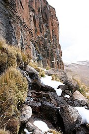
| Source | Apacheta cliff |
| - location | Nevado Mismi, Arequipa, Peru |
| - elevation | 5,170 m (16,962 ft) |
| - coordinates | |
| Mouth | |
| - location | Atlantic Ocean, Brazil |
| - elevation | 0 m (0 ft) |
| Length | 6,400 km (4,000 mi) approx. |
| Basin | 7,050,000 km² (2,720,000 sq mi) approx. |
| Discharge | mouth |
| - average | 219,000 m³/s (7,734,000 cu ft/s) |
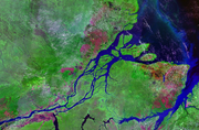
 Map showing the Amazon drainage basin with the Amazon River highlighted
|
|
The Amazon River (Portuguese: Rio Amazonas; Spanish: Río Amazonas) of South America is the largest river in the world by volume, with a total river flow greater than the next eight largest rivers combined. The Amazon, which has the largest drainage basin in the world, accounts for approximately one fifth of the world's total river flow. During the wet season The Amazon is 120 miles (190 km) - 130 miles (210 km) wide. Because of its vast dimensions, it is sometimes called The River Sea. At no point is the Amazon crossed by bridges.[1] This is only partly because of its huge dimensions—in fact, for most of its length the Amazon is not so wide that a modern bridge could not span it—but more because, for most of its length, the river flows through tropical rainforest, where there are few roads and even fewer cities.
While some say the Amazon is the largest river in the world, the current consensus within the geographic community holds that the Amazon is the second longest river, just slightly shorter than the Nile. However, some scientists, particularly from Brazil and Peru, dispute this (see section below).
Contents |
[edit] Drainage area
The Amazon basin, the largest and the longest drainage basin in the world, covers about 40 percent of South America, an area of approximately 6,915,000 square kilometres (2,670,000 sq mi) . It gathers its waters from 5 degrees north latitude to 20 degrees south latitude. Its most remote sources are found on the inter-Andean plateau, just a short distance from the Pacific Ocean.
The area covered by the water of the Amazon River and its tributaries more than triples over the course of a year. In an average dry season 110,000 square kilometres (42,000 sq mi) of land are water-covered, while in the wet season the flooded area of the Amazon Basin rises to 350,000 square kilometres (135,000 sq mi) .[citation needed]
The quantity of water released by the Amazon to the Atlantic Ocean is enormous: up to 300,000 m³ per second in the rainy season. The Amazon is responsible for a fifth of the total volume of fresh water entering the oceans worldwide. Offshore of the mouth of the Amazon, potable water can be drawn from the ocean while still out of sight of the coastline, and the salinity of the ocean is notably lower five hundred kilometres out to sea.
[edit] Origins of the river


The Upper Amazon has a series of major river systems in Peru and Ecuador, some of which flow into the Marañón and others directly into the Amazon proper. Among others, these include the following rivers: Morona, Pastaza, Nucuray, Urituyacu, Chambira, Tigre, Nanay, Napo, Huallaga, and Ucayali. The headstreams of the Marañón—which for many years had been seen as the origin of the Amazon—flow from high above central Peru's Lake Lauricocha, from the glaciers in what is known as the Nevado de Yarupa. Rushing through waterfalls and gorges in an area of the high jungle called the pongos, the Marañón River flows about 1,600 kilometres (1,000 mi) from west-central to northeast Peru before it combines with the Ucayali River, just below the provincial town of Nauta, to form the Amazon River.
The most distant source of the Amazon was firmly established in 1996,[2] 2001[3] and 2007[4] as a glacial stream on a snowcapped 5,597 m (18,363 ft) peak called Nevado Mismi in the Peruvian Andes, roughly 160 km (100 mi) west of Lake Titicaca and 700 km (430 mi) southeast of Lima. The waters from Nevado Mismi flow into the Quebradas Carhuasanta and Apacheta, which flow into the Río Apurímac which is a tributary of the Ucayali which later joins the Marañón to form the Amazon proper. (While this is the point at which most geographers place the beginning of the Amazon proper, in Brazil the river is known at this point as the Solimões das Águas). Soon thereafter the darkly colored waters of the Rio Negro meet the sandy colored Rio Solimões, and for over 6 km these waters run side by side without mixing.
After the confluence of Río Apurímac and Ucayali, the river leaves Andean terrain and is instead surrounded by flood plain. From this point to the Marañón, some 1,600 km (990 mi) , the forested banks are just out of water, and are inundated long before the river attains its maximum flood-line. The low river banks are interrupted by only a few hills, and the river enters the enormous Amazon Rainforest.
The river systems and flood plains in Brazil, Peru, Ecuador, Colombia and Venezuela whose waters drain into the Solimões and its tributaries are called the "Upper Amazon". The Amazon River proper runs mostly through Brazil and Peru, and it has tributaries reaching into Venezuela, Colombia, Ecuador, and Bolivia.
[edit] Flooding

Not all of the Amazon's tributaries flood at the same time of the year. Many branches begin flooding in November, and may continue to rise until June. The rise of the Rio Negro starts in February or March, and it also begins to recede in June. The Madeira rises and falls two months earlier than most of the rest of the Amazon.
The average depth of the river in the height of the rainy season is 40 metres (131 feet) and the average width can be nearly 40 km (25 mi)[citation needed].
The main river (which is between approximately one and six miles (10 km) wide) is navigable for large ocean steamers to Manaus, 1,500 kilometres (930 mi) upriver from the mouth. Smaller ocean vessels of 3,000 tons or 9,000 tons[5] and 5.5 metres (18 ft) draft can reach as far as Iquitos, Peru, 3,600 kilometres (2,240 mi) from the sea. Smaller riverboats can reach 780 kilometres (485 mi) higher as far as Achual Point. Beyond that, small boats frequently ascend to the Pongo de Manseriche, just above Achual Point.
[edit] Towards the sea

At some points, for long distances, the river divides into two main streams with inland and lateral channels, all connected by a complicated system of natural canals, cutting the low, flat igapo lands, which are never more than 5 metres (16 ft) above low river, into many islands.
From the village of Canaria at the great bend of the Amazon to the Negro, only very low land is found, resembling that at the mouth of the river.[citation needed] Vast areas of land in this region are submerged at high water, above which only the upper part of the trees of the sombre forests appear. Near the mouth of the Rio Negro to Serpa, nearly opposite the river Madeira, the banks of the Amazon are low, until approaching Manaus, they rise to become rolling hills. At Óbidos, a bluff 17 m (56 ft) above the river is backed by low hills. The lower Amazon seems to have once been a gulf of the Atlantic Ocean, the waters of which washed the cliffs near Óbidos.
Only about 10% of the water discharged by the Amazon enters the mighty stream downstream of Óbidos, very little of which is from the northern slope of the valley. The drainage area of the Amazon basin above Óbidos city is about 5 million square kilometres (2,000,000 sq mi), and, below, only about 1 million square kilometres (400,000 sq mi or around 20%), exclusive of the 1.4 million square kilometres (540,000 sq mi) of the Tocantins basin.
In the lower reaches of the river, the north bank consists of a series of steep, table-topped hills extending for about 240 kilometres (149 mi) from opposite the mouth of the Xingu as far as Monte Alegre. These hills are cut down to a kind of terrace which lies between them and the river.
Monte Alegre reaches an altitude of several hundred meters. On the south bank, above the Xingu, an almost-unbroken line of low bluffs bordering the flood-plain extends nearly to Santarem, in a series of gentle curves before they bend to the south-west, and, abutting upon the lower Tapajos, merge into the bluffs which form the terrace margin of the Tapajos river valley.
[edit] Mouth of the river
The Amazon estuary is some 330 kilometres (210 mi) wide. The width of the mouth of the river is usually measured from Cabo do Norte to Punto Patijoca. But this includes the ocean outlet, 60 km (40 mi) wide, of the Para river, which should be deducted, as this stream is only the lower reach of the Tocantins. It also includes the ocean frontage of Marajó, an island lying in the mouth of the Amazon. This means that the Amazon is wider at its mouth than the entire length of the Thames in England.
[edit] Tidal bore
Following the coast, a little to the north of Cabo do Norte, and for 160 kilometres (100 mi) along its Guiana margin up the Amazon, is a belt of half-submerged islands and shallow sandbanks. Here the tidal phenomenon called the bore, or pororoca, occurs, where the depths are not over 7 metres (23 ft). The tidal bore starts with a roar, constantly increasing, and advances at the rate of from 15–25 km/h (9–16 mph), with a breaking wall of water from 1.5–4.0-metres (5–13 ft) high. The bore is the reason the Amazon does not have a protruding delta; the ocean rapidly carries away the vast volume of silt carried by the Amazon, making it impossible for a delta to grow past the shoreline. It also has a very large tide sometimes reaching 6 metres (20 ft) and has become a popular spot for river surfing.[6]
[edit] Wildlife
More than one third of all species in the world live in the Amazon Rainforest[7], a giant tropical forest and river basin with an area that stretches more than 5.4 million square kilometres (2,100,000 sq mi) and is among the richest tropical forests in the world. The Amazon River has over 3,000 recognized species of fish and that number is still growing. Some estimates go as high as 5,000.
Along with the Orinoco, the river is one of the main habitats of the Boto, also known as the Amazon River Dolphin. The largest species of river dolphin, it can grow to lengths of up to 2.6 metres (9 ft). The boto is the subject of a very famous legend in Brazil, about a dolphin that turns into a human.
Also present in large numbers are the notorious piranha, carnivorous fish which congregate in large schools, and may attack livestock and even humans. However, only a few species attack humans, and many are solely fish-eaters, and do not school.
The bull shark (Carcharhinus leucas) has been reported 4,000 km (2,220 miles) up the Amazon River at Iquitos in Peru. The arapaima, or pirarucu (Arapaima gigas) is a South American tropical freshwater fish. It is one of the largest freshwater fish in the world, reportedly with a maximum length in excess of 3 m (9.8 ft) and weight up to 200 kg (440 lb). Another Amazonian freshwater fish is the arowana (Osteoglossum bicirrhosum) which is also a predator and very similar to the arapaima, but reaches a length of maximum 120 centimetres.
The Anaconda snake is found in shallow waters in the Amazon basin. One of the world's largest species of snake, the Anaconda spends most of its time in the water, with just its nostrils above the surface.
The river supports thousands of species of fish, as well as crabs, algae, and turtles.
[edit] Colonial encounter and Amazonia
During what many archaeologists call the formative period, Amazonian societies were deeply involved in the emergence of South America's highland agrarian systems, and possibly contributed directly to the social and religious fabric constitutive of the Andean civilizational orders.
In 1500, Vicente Yañez Pinzón was the first European to sail into the river. Pinzón called the river flow Río Santa María de la Mar Dulce, later shortened to Mar Dulce (literally, sweet sea, because of its freshwater pushing out into the ocean). For 350 years after the first European encounter of the Amazon by Pinzón, the Portuguese portion of the basin remained an untended former food gathering and planned agricultural landscape occupied by the indigenous peoples who survived the arrival of European diseases. There is ample evidence for complex large-scale, pre-Columbian social formations, including chiefdoms, in many areas of Amazonia (particularly the inter-fluvial regions) and even large towns and cities.[8] For instance the pre-Columbian culture on the island of Marajo may have developed social stratification and supported a population of 100,000 people.[9] The Native Americans of the Amazon rain forest may have used Terra preta to make the land suitable for the large scale agriculture needed to support large populations and complex social formations such as chiefdoms.[9]
One of Gonzalo Pizarro's lieutenants, Francisco de Orellana, during his 1541 expedition, east of Quito into the South American interior in search of El Dorado and the Country of the Cinnamon was ordered to explore the Coca River and return when the river ended. When they arrived to the confluence to the Napo River, his men menaced to mutiny if they did not continue. On 26 December 1541, he accepted to be elected chief of the new expedition and to conquest new lands in name of the king. The 49 men began to build a bigger ship for riverine navigation. During their navigation on Napo River they were threatened constantly by the Omaguas. They reached Negro River on 3 June 1542 and finally arrived to the Amazon River, that was so named because they were attacked by fierce female warriors like the mythological Amazons. The icamiabas Indians dominated the area close to the Amazon River, rich in gold. When Orellana went down the river in search of gold, descends Andes (in 1541), the river was still called Grande Rio, Mar Dulce or Rio da Canela (Cinnamon), because of the great trees of cinnamon located there. The belligerent victory of the icamiabas against the Spanish invaders was such that the fact was narrated to the king Carlos V, whom, inspired by the Greek Amazons, baptized the river as Amazon.
In what is currently Brazil, Ecuador, Bolivia, Colombia, Peru, and Venezuela a number of colonial and religious settlements were established along the banks of primary rivers and tributaries for the purpose of trade, slaving and evangelization among the indigenous peoples of the vast rain forest.
The total population of the Brazilian portion of the Amazon basin in 1850 was perhaps 300,000, of whom about two-thirds comprised by Europeans and slaves, the slaves amounting to about 25,000. In Brazil, the principal commercial city, Para (now Belém), had from 10,000 to 12,000 inhabitants, including slaves. The town of Manáos, now Manaus, at the mouth of the Rio Negro, had from 1,000 to 1,500 population. All the remaining villages, as far up as Tabatinga, on the Brazilian frontier of Peru, were relatively small.
[edit] Post colonial history
On 6 September 1850, the emperor, Peter II, sanctioned a law authorizing steam navigation on the Amazon, and gave the Baron of Mauá (Irineu Evangilista de Sousa) the task of putting it into effect. He organized the "Compania de Navigacao e Commercio do Amazonas" at Rio de Janeiro in 1852; and in the following year it commenced operations with three small steamers, the Monarch, the Marajó and Rio Negro.
At first, navigation was principally confined to the main river; and even in 1857 a modification of the government contract only obliged the company to a monthly service between Pará and Manaus, with steamers of 200 tons cargo capacity, a second line to make six round voyages a year between Manaus and Tabatinga, and a third, two trips a month between Para and Cameta. This was the first step in opening up the vast interior.
The success of the venture called attention to the opportunities for economic exploitation of the Amazon, and a second company soon opened commerce on the Madeira, Purus and Negro; a third established a line between Pará and Manaus; and a fourth found it profitable to navigate some of the smaller streams. In that same period, the Amazonas Company was increasing its fleet. Meanwhile, private individuals were building and running small steam craft of their own on the main river as well as on many of its tributaries.
On 31 July 1867 the government of Brazil, constantly pressed by the maritime powers and by the countries encircling the upper Amazon basin, especially Peru, decreed the opening of the Amazon to all flags; but limited this to certain defined points: Tabatinga—on the Amazon; Cameta—on the Tocantins; Santarem—on the Tapajos; Borba—on the Madeira and Manáos—on the Rio Negro. The Brazilian decree took effect on 7 September 1867.
Thanks in part to the mercantile development associated with steam boat navigation, coupled with the internationally driven demand for natural rubber (1880-1920), Manáos (now Manaus), Para (Brazil), and Iquitos, Peru became thriving, cosmopolitan centers of commerce and spectacular—albeit illusory—modern "urban growth". This was particularly the case for Iquitos during its late 19th and early 20th century Rubber Bonanza zenith when this dynamic boom-town was known abroad as the St. Louis of the Amazon.
The first direct foreign trade with Manáos was commenced around 1874. Local trade along the river was carried on by the English successors to the Amazonas Company—the Amazon Steam Navigation Company—as well as numerous small steamboats, belonging to companies and firms engaged in the rubber trade, navigating the Negro, Madeira, Purfis and many other tributaries, such as the Marañón to ports as distant as Nauta, Peru. The Amazon Steam Navigation Company had 38 vessels.
By the turn of the 20th century, the principal exports of the Amazon Basin were india-rubber, cacao, Brazil nuts and a few other products of minor importance, such as pelts and exotic forest produce (resins, barks, woven hammocks, prized bird feathers, live animals, etc.) and extracted goods (lumber, gold, etc.).
[edit] 20th century concerns
Four centuries after the European discovery of the Amazon river, the total cultivated area in its basin was probably less than 65 square kilometres (25 sq mi), excluding the limited and crudely cultivated areas among the mountains at its extreme headwaters. This situation changed dramatically during the 20th century.

Wary of foreign exploitation of the nation's resources, Brazilian governments in the 1940s set out to develop the interior, away from the seaboard where foreigners owned large tracts of land. The original architect of this expansion was President Getúlio Vargas, the demand for rubber from the Allied forces in World War II providing funding for the drive.
The construction of the new capital Brasilia in the interior in 1960 also contributed to the opening up of the Amazon basin. A large scale colonization program saw families from north-eastern Brazil relocated to the forests, encouraged by promises of cheap land. Many settlements grew along the road from Brasilia to Belém, but rainforest soil proved difficult to cultivate.
Still, long-term development plans continued. Roads were cut through the forests, and in 1970, the work on Trans-Amazon highway network began. The network's three pioneering highways were completed within ten years, connecting all the major cities of the Brazilian Amazon interior.
[edit] Dispute regarding length
While debate as to whether the Amazon or the Nile is the world's longest river has gone on for many years, the historic consensus of geographic authorities has been to regard the Amazon as the second longest river in the world, with the Nile being the longest. However, the Amazon has been measured by different geographers as being anywhere between 6,259 and 6,800 kilometres (3,889–4,225 mi) long. The Nile is reported to be anywhere from 5,499 to 6,690 kilometres (3,417–4,157 mi). The differences in these measurements often result from the use of different definitions.
A study by Brazilian scientists claimed that the Amazon is actually longer than the Nile-(the Amazon River being 6,800km long and the Nile being 6,985km). Using Nevado Mismi, which in 2001 was labeled by the National Geographic Society as the Amazon's source, these scientists have made new calculations of the Amazon's length. They now estimate that the Amazon is 105 kilometres (65 mi) longer than the Nile,[10] and Guido Gelli, director of science at the Brazilian Institute of Geography and Statistics (IBGE), told the Brazilian TV network Globo in June 2007 that it could be considered as a fact that the Amazon was the longest river in the world. However, other geographers have had access to the same data since 2001, and a consensus has yet to emerge to support the claims of these Brazilian scientists.
[edit] Major tributaries
The Amazon has over 1,000 tributaries in total, 17 of which are over 1,000 kilometers. Some of the more notable:
[edit] Longest rivers in the Amazon system
- 6,992 km (4,345 mi) - Amazon, South America
- 3,379 km (2,100 mi) - Purus, Peru / Brazil, (2,948 km) (3,210 km)[citation needed]
- 3,239 km (2,013 mi) - Madeira, Bolivia / Brazil
- 2,820 km (1,752 mi) - Yapura, Colombia / Brazil
- 2,750 km (1,709 mi) - Tocantins, Brazil, (2,416 km) (2,640 km)[citation needed]
- 2,575 km (1,600 mi) - Araguaia, Brazil (tributary of Tocantins)
- 2,410 km (1,498 mi) - Juruá, Peru / Brazil
- 2,250 km (1,398 mi) - Rio Negro, Brazil/ Venezuela / Colombia
- 2,100 km (1,305 mi) - Xingu, Brazil
- 1,900 km (1,181 mi) - Tapajós, Brazil
- 1,749 km (1,087 mi) - Guaporé, Brazil / Bolivia (tributary of Madeira)
- 1,600 km (1,030 mi) - Ucayali River, Peru
- 1,575 km (979 mi) - Içá (Putumayo), South America
- 1,415 km (879 mi) - Marañón, Peru / Ecuador
- 1,370 km (851 mi) - Teles Pires, , Brazil (tributary of Tapajós)
- 1,300 km (808 mi) - Iriri, Brazil (tributary of Xingu)
- 1,240 km (771 mi) - Juruena, Brazil (tributary of Tapajós)
- 1,200 km (746 mi) - Tapajós, Brazil
- 1,130 km (702 mi) - Madre de Dios, Peru / Bolivia (tributary of Madeira)
- 1,100 km (684 mi) - Huallaga, Peru (tributary of Marañón)
[edit] Expeditions
The Amazon River is currently being walked from source to sea by Ed Stafford(UK), having started in April 2008. It is believed to be the first navigation of the Amazon on foot.
[edit] References
- ^ "Amazon (river)". Microsoft Encarta Online Encyclopedia. http://encarta.msn.com/encyclopedia_761571466/Amazon_(river).html. Retrieved on 2007-08-12.
- ^ Source of the Amazon River Identificated (Jacek Palkiewicz)
- ^ Explorers Pinpoint Source of the Amazon (National Geographic News)
- ^ Amazon river 'longer than Nile' (BBC news) (2007-06-16)
- ^ Amazon uk.encarta.msn.com. Retrieved 1 October 2006.
- ^ "Pororoca: surfing the Amazon". http://fogonazos.blogspot.com/2007/03/pororoca-surfing-amazon.html. Retrieved on 2008-08-01.
- ^ Amazon rainforest fact sheet
- ^ Mann, C, C., ed. (2005). 1491: New Revelations of the Americas Before Columbus. University of Texas. pp. 296. ISBN 1400032059.
- ^ a b Mann, C, C., ed. (2005). 1491: New Revelations of the Americas Before Columbus. University of Texas. ISBN 1400032059.
- ^ Amazon Longer Than Nile River, Scientists Say
- This article incorporates text from the Encyclopædia Britannica, Eleventh Edition, a publication now in the public domain.
[edit] External links
| Wikimedia Commons has media related to: Amazon river |
- Amazon dries up Youtube (31 July 2006)
- Bibliography on Water Resources and International Law Peace Palace Library
- Information on the Amazon from Extreme Science
- Pictures of the Amazon River
- Information and a map of the Amazon's watershed
- Amazon Alive: Light & Shadow documentary film about the Amazon river
- http://www.extremescience.com/AmazonRiver.htm

