Kauai
From Wikipedia, the free encyclopedia
|
Kauaʻi
The Garden Isle |
|
 |
|
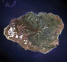
| August 1995 satellite photo. | |
| Geography | |
 |
|
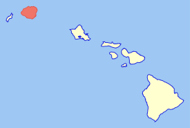
| Location in the state of Hawaii. | |
|
|
|
| Location | |
| Area | 552.3 sq mi (1430.4 km²) |
| Rank | 4th largest Hawaiian Island |
| Highest point | Kawaikini |
|
|
| Demographics | |
| Population | 58,303 (as of 2000) |
| Density | 106/sq mi (41/km²) |
| Official Insignias | |
| Flower | Mokihana (Melicope anisata)[1] |
| Color |
Poni (purple)
|
Kauaʻi or Kauai (pronounced /ˈkaʊ.aɪ/ in English and [kouˈɐʔi] or [kɐuˈɐʔi] in Hawaiian) is the oldest of the main Hawaiian Islands. With an area of 552.3 square miles (1,430.5 km2), it is the fourth largest of the main islands in the Hawaiian archipelago and the 21st largest island in the United States.[2] Known also as the "Garden Isle", Kauaʻi lies 105 miles (170 kilometers) across the Kauaʻi Channel, northwest of Oʻahu.
The United States Census Bureau defines Kauaʻi as Census Tracts 401 through 409 of Kauaʻi County, Hawaiʻi, which is all of the county except for the islands of Kaʻula, Lehua, and Niʻihau. The 2000 census population of Kauaʻi (the island) was 58,303.[3]
Contents |
[edit] Etymology and language
There is no known meaning behind the name of Kauaʻi. Native Hawaiian tradition indicates the name's origin in the legend of Hawaiʻiloa — the Polynesian navigator attributed with discovery of the Hawaiian Islands. The story relates how he named the island of Kauaʻi after a favorite son; therefore a possible translation of Kauaʻi is "place around the neck", meaning how a father would carry a favorite child. Another possible translation is "food season."[4]
Kauaʻi was known for its distinct dialect of the Hawaiian language before it went extinct there. Whereas the standard language today is based on the dialect of Hawaiʻi island, the Kauaʻi dialect was known for pronouncing /k/ as /t/. (In fact, Kauaʻi retained the old pan-Polynesian /t/, while Hawaiʻi has innovated and changed it.) Therefore, the native name for Kauaʻi was Tauaʻi, and the major settlement of Kapaʻa would have been called Tapaʻa.
[edit] Geography
Kauai's origins are volcanic. The highest peak on this mountainous island is Kawaikini at 5,243 feet (1,598 m).[5] The second highest peak is Mount Waiʻaleʻale near the center of the island, 5,148 feet (1,569 m) above sea level. One of the wettest spots on Earth, with an annual average rainfall of 460 inches (11,700 mm), is located on the east side of Mount Waiʻaleʻale. The high annual rainfall has eroded deep valleys in the central mountains, carving out canyons with many scenic waterfalls. On the west side of the island, Waimea town is located at the mouth of the Waimea River, whose flow formed Waimea Canyon, one of the most scenic canyons in the world, and which is part of Waimea Canyon State Park. At 3,000 feet (914 m) deep, Waimea Canyon is often referred to as "The Grand Canyon of the Pacific".
[edit] History
During the reign of King Kamehameha, the islands of Kauaʻi and Niʻihau were the last Hawaiian Islands to join his Kingdom of Hawaiʻi. Their ruler, Kaumualiʻi, resisted Kamehameha for years. King Kamehameha twice prepared a huge armada of ships and canoes to take the islands by force and twice failed; once due to a storm, and once due to an epidemic. In the face of the threat of a further invasion, however, Kaumualiʻi decided to join the kingdom without bloodshed, and became Kamehameha's vassal in 1810, ceding the island to the Kingdom of Hawaiʻi upon his death.
[edit] Economy
Tourism is Kauai's largest industry. In 2007, 1,271,000 visitors came to Kauai, and the two largest groups were from the United States (84% of all visitors) and Japan (3%).[6] As of 2003, there were a total of approximately 27,000 jobs on Kauai, of which the largest sector was accommodations–food services (26%, 6,800 jobs) followed by government (15%) and retail (14.5%), with agriculture accounting for just 2.9% (780 jobs) and educational services providing just 0.7% (183 jobs).[7] In terms of income, the various sectors that are comprised by the visitors industry accounted for one third of Kauai's income.[8] On the other hand, employment is dominated by small businesses, with 87% of all nonfarm businesses having fewer than 20 employees.[9]
As of 2003, Kauai's unemployment rate was 3.9%, compared to 3.0% for the entire state and 5.7% for the United States as a whole; and, Kauai's poverty rate was 10.5%, compared to the State's 10.7%.[10] As of mid-2004, the median price of a single family home was $528,000, a 40% increase over 2003. As of 2003, Kauai's percentage of home ownership, 48%, was significantly lower than the State's 64%, and vacation homes were a far larger part of the housing stock than the State-wide percentage (Kauai 15%, State 5%).[11].
In the past, sugar plantations were Kauai's most important industry, but most of that land is now used for ranching.[12] Kauai's sole remaining sugar operation, the 118-year-old Gay & Robinson Plantation has announced that it plans to transform itself into a manufacturer of ethanol from sugar cane.[13]
[edit] Fruits and crops
Land in Kauaʻi is very fertile and is home to many varieties of fruits and crops. Guava, sugarcane and pineapple are all grown on Kauai.
[edit] Island facts

The city of Līhuʻe, on the island's southeast coast, is the seat of Kauaʻi County and the second largest city on the island. Kapaʻa, on the "Coconut Coast" (site of an old coconut plantation) about 6 miles (9.7 km) north of Līhuʻe, has a population of nearly 10,000, or about 50% greater than Līhuʻe. Waimea, once the capital of Kauaʻi on the island's southwest side, was the first place in Hawaiʻi visited by British explorer Captain James Cook in 1778.

1992's Hurricane Iniki may have caused an indirect change in Kauaʻi's ecosystem. Some say a chicken farm was destroyed, causing all of the chickens to roam free that one may see today. Others say that sugarcane plantation laborers in the late 1800s and early 1900s brought and raised chickens (for eating and cockfighting) and many got loose over the years and multiplied. Whatever their original source, Kauai is now home to thousands of wild roosters and hens, roaming the island with few natural predators. Wild roosters have been known to disturb evening quiet time at odd hours with their crowing. Currently, the Humane Society is investigating the death of large numbers of Kauai chickens. The deaths are most likely due to bacterial infections caused by over-population. [14]
The island of Kauaʻi has been featured in more than 70 Hollywood movies and television shows, including the musical South Pacific and Disney's 2002 animated feature film and television series Lilo & Stitch. Scenes from South Pacific were filmed in the vicinity of Hanalei. Waimea Canyon was used in the filming of the 1993 film Jurassic Park. Parts of the island were also used for the opening scenes of Raiders of the Lost Ark. Other movies filmed here include Six Days Seven Nights, the remake of King Kong and John Ford's 1963 film Donovan's Reef.
Kauaʻi is home to the U.S. Navy's "Barking Sands" Pacific Missile Range Facility, on the sunny and dry western shore.


[edit] Important towns and cities

Cities and towns on Kauaʻi range in population from the roughly 9,500 people in Kapaʻa to tiny hamlets. The list below lists the larger or more notable of those from the northernmost end of Hawaii Route 560 to the western terminus of Hawaii Route 50.
- Hāʻena
- Wainiha
- Hanalei
- Princeville
- Kilauea
- Anahola
- Kapaʻa
- Wailua
- Hanamāʻulu
- Līhuʻe
- Poʻipū
- Kōloa
- Lāwaʻi
- Kalāheo
- ʻEleʻele
- Hanapēpe
- Waimea
- Kekaha
[edit] Transportation
Lihue Airport serves the island.
[edit] Places of interest

- Alakai Wilderness Area
- Allerton Garden
- Bell stone
- Camp Naue YMCA
- Fern Grotto
- Hanalei Bay
- Iraivan temple
- Keʻe Beach
- Kokeʻe State Park
- Limahuli Garden and Preserve
- McBryde Garden
- Makeleha Mountains
- Moir Gardens
- Moloaa Bay
- Na 'Aina Kai Botanical Gardens
- Nā Pali Coast State Park
- Polihale State Park
- 'Opaeka'a Falls
- Sleeping Giant (Nounou Mountain)
- Spouting Horn
- Wailua River
- Waimea Canyon
- Princeville North Shore
[edit] See also
[edit] Notes
- ^ "Mokihana". Native Hawaiian Plants. Kapiʻolani Community College. http://old.kcc.hawaii.edu/campus/tour/plants/pmokihana.htm. Retrieved on 2009-03-07.
- ^ "Table 5.08 - Land Area of Islands: 2000". 2004 State of Hawaii Data Book. State of Hawaii. 2004. http://www.hawaii.gov/dbedt/info/economic/databook/db2004/section05.pdf. Retrieved on 2007-07-23.
- ^ Census Tracts 401 through 409, Kauaʻi County United States Census Bureau
- ^ Pukui, Mary Kawena. Place Names of Hawaii. University of Hawaii Press. ISBN 0-8248-0524-0.
- ^ "Table 5.11 - Elevations of Major Summits". 2004 State of Hawaii Data Book. State of Hawaii. 2004. http://www.hawaii.gov/dbedt/info/economic/databook/db2004/section05.pdf. Retrieved on 2007-07-23.
- ^ "Kauai Economic Outlook Summary: Tourism Woes Mean No Growth Through 2009". University of Hawaii Economic Research Organization]. 2008. http://www.kauai.gov/Government/Departments/EconomicDevelopment/EconomicStatisticsandForecasting/tabid/256/Default.aspx. Retrieved on 2008-11-05.
- ^ "Kauai Economic Development Plan 2005-20015". County of Kauaii Office of Economic Development,Kauai Economic Development Board]. 2004. http://www.kauai.gov/portals/0/oed/KEDP_2005-2015.pdf. Retrieved on 2008-11-05.
- ^ "Kauai Economic Development Plan 2005-20015". County of Kauaii Office of Economic Development,Kauai Economic Development Board]. 2004. http://www.kauai.gov/portals/0/oed/KEDP_2005-2015.pdf. Retrieved on 2008-11-05.
- ^ "Kauai Economic Development Plan 2005-20015". County of Kauaii Office of Economic Development,Kauai Economic Development Board]. 2004. http://www.kauai.gov/portals/0/oed/KEDP_2005-2015.pdf. Retrieved on 2008-11-05.
- ^ "Kauai Economic Development Plan 2005-20015". County of Kauaii Office of Economic Development,Kauai Economic Development Board]. 2004. http://www.kauai.gov/portals/0/oed/KEDP_2005-2015.pdf. Retrieved on 2008-11-05.
- ^ "Kauai Economic Development Plan 2005-20015". County of Kauaii Office of Economic Development,Kauai Economic Development Board]. 2004. http://www.kauai.gov/portals/0/oed/KEDP_2005-2015.pdf. Retrieved on 2008-11-05.
- ^ "Kauai Economic Outlook Summary: Tourism Woes Mean No Growth Through 2009". University of Hawaii Economic Research Organization]. 2008. http://www.kauai.gov/Government/Departments/EconomicDevelopment/EconomicStatisticsandForecasting/tabid/256/Default.aspx. Retrieved on 2008-11-05.
- ^ "Kauai Economic Outlook Summary: Tourism Woes Mean No Growth Through 2009". University of Hawaii Economic Research Organization]. 2008. http://www.kauai.gov/Government/Departments/EconomicDevelopment/EconomicStatisticsandForecasting/tabid/256/Default.aspx. Retrieved on 2008-11-05.
- ^ Kauai Garden Island News
[edit] References
- Edward Joesting. Kauaʻi, the Separate Kingdom. University of Hawaiʻi Press and Kauaʻi Museum Association. Honolulu. 1984. ISBN 0-8248-1162-3
- Cook, Chris (October 1996). The Kaua’i Movie Book. Landscape photography by David Boynton. Honolulu: Mutual Publishing. ISBN 1-56647-141-9.
[edit] External links
| Wikimedia Commons has media related to: Kauai |
- Kauaʻi Chamber of Commerce - Essential business information
- Kauai Visitors Bureau
- Ascents of Waialeale and Kawaikini. Hikes in the Alakai Swamp and Waimea Canyon
[edit] News and resource links
- The Kauai Garden Island News ~ main local newspaper
- Hawaii Weather Today - Glenn's daily Weather Narrative
- Pacific Disaster Center - The Source for Daily Pacific Disaster News
- North Shore Kaua'i - News for the Garden Island's North Shore
|

