Hadrian's Wall
From Wikipedia, the free encyclopedia
 |
|
| This article is part of the series on: Military of ancient Rome (portal) 800 BC – AD 476 |
|
| Structural history | |
|---|---|
| Roman army (unit types and ranks, legions, auxiliaries, generals) | |
| Roman navy (fleets, admirals) | |
| Campaign history | |
| Lists of wars and battles | |
| Decorations and punishments | |
| Technological history | |
| Military engineering (castra, siege engines, arches, roads) | |
| Personal equipment | |
| Political history | |
| Strategy and tactics | |
| Infantry tactics | |
| Frontiers and fortifications (limes, Hadrian's Wall) | |
Hadrian's Wall (Latin: perhaps Vallum Aelium, "the Aelian wall") is a stone and turf fortification built by the Roman Empire across the width of what is now northern England. Begun in AD 122, during the rule of emperor Hadrian, it was the middle of three such fortifications built across Great Britain, the first being from the River Clyde to the River Forth under Agricola and the last the Antonine Wall. All were built to prevent military raids on Roman Britain by the Pictish tribes (ancient inhabitants of Scotland) to the north, to improve economic stability and provide peaceful conditions in Britain, and to mark physically the frontier of the Empire. Hadrian's Wall is the best known of the three because its physical presence remains most evident today.
The wall marked the northern limes in Britain and also the most heavily fortified border in the Empire. In addition to its use as a military fortification, it is thought that the gates through the wall would also have served as customs posts to allow trade taxation.
A significant portion of the wall still exists, particularly the mid-section, and for much of its length the wall can be followed on foot. It is the most popular tourist attraction in Northern England, where it is often known simply as the Roman Wall. It was made a UNESCO World Heritage Site in 1987. English Heritage, a government organization in charge of managing the historic environment of England, describes it as "the most important monument built by the Romans in Britain".[1]
Contents |
[edit] Dimensions
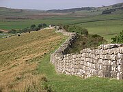
Hadrian's Wall was 80 Roman miles (73.5 statute miles or 117 kilometres) long[2], its width and height dependent on the construction materials which were available nearby. East of River Irthing the wall was made from squared stone and measured 3 metres (9.7 ft) wide and five to six metres (16–20 ft) high, while west of the river the wall was made from turf and measured 6 metres (20 ft) wide and 3.5 metres (11.5 ft) high. This does not include the wall's ditches, berms, and forts. The central section measured eight Roman feet wide (7.8 ft or 2.4 m) on a 10-foot (3.0 m) base. Some parts of this section of the wall survive to a height of 10 feet (3.0 m).
[edit] Route


Hadrian's Wall extended west from Segedunum at Wallsend on the River Tyne to the shore of the Solway Firth. The A69 and B6318 roads follow the course of the wall as it starts in Newcastle upon Tyne to Carlisle, then on round the northern coast of Cumbria. The wall is entirely in England and south of the border with Scotland by 15 kilometres (9 mi) in the west and 110 kilometres (68 mi) in the east.
[edit] Hadrian
Hadrian's Wall was built following a visit by Roman Emperor Hadrian (AD 76–138) in AD 122. Hadrian was experiencing military difficulties in Roman Britain and from the peoples of various conquered lands across the Empire, including Egypt, Judea, Libya, Mauretania, and many of the peoples conquered by his predecessor Trajan, so he was keen to impose order. However the construction of such an impressive wall was probably also a symbol of Roman power, both in occupied Britain and in Rome.
Frontiers in the early empire were largely based on natural features or fortified zones with a heavy military presence. Military roads often marked the border, with forts and signal towers spread along them, and it was not until the reign of Domitian that the first solid frontier was constructed, in Germania Superior, using a simple fence. Hadrian expanded this idea, redesigning the German border by ordering a continuous timber palisade supported by forts behind it. Although such defences would not have held back any concerted invasion effort, they did physically mark the edge of Roman territory and went some way to providing a degree of control over who crossed the border and where.
Hadrian reduced Roman military presence in the territory of the Brigantes, who lived between the rivers Tyne and Humber, and concentrated on building a more solid linear fortification to the north of them. This was intended to replace the Stanegate road which is generally thought to have served as the limes (the boundary of the Roman Empire) until then.
[edit] Construction
Construction probably started in AD 122 and was largely completed within six years.[3] Construction started in the east and proceeded westwards, with soldiers from all three of the occupying Roman legions participating in the work. The route chosen largely paralleled the nearby Stanegate road from Luguvalium (Carlisle) to Coria (Corbridge), which was already defended by a system of forts, including Vindolanda. The wall in the east follows the outcrop of a hard, resistant igneous diabase rock escarpment, known as the Whin Sill. The wall incorporated Agricola's Ditch.[4] The wall was constructed primarily to prevent entrance by small bands of raiders or unwanted immigration from the north, not as a fighting line for a major invasion according to Johnson.[5]
The initial plan called for a ditch and wall with eighty small gated milecastle fortlets, one placed every Roman mile, holding a few dozen troops each, and pairs of evenly spaced intermediate turrets used for observation and signalling. Local limestone was used in the construction, except for the section to the west of Irthing where turf was used instead, since there were no useful outcrops nearby. Milecastles in this area were also built from timber and earth rather than stopione, but turrets were always made from stone. The Broad Wall was initially built with a clay-bonded rubble core and mortared dressed rubble facing stones, but this seems to have made it vulnerable to collapse, and repair with a mortared core was sometimes necessary.

The milecastles and turrets were of three different designs, depending on which Roman legion built them — inscriptions of the Second, Sixth, and Twentieth Legions, tell us that all were involved in the construction. All were about 493 metres (539 yards) apart and measured 4.27 square metres (46.0 square feet) internally.
Construction was divided into lengths of about 5 miles (8 km). One group of each legion would excavate the foundations and build the milecastles and turrets and then other cohorts would follow with the wall construction.
Early in its construction, just after reaching the North Tyne, the width of the wall was narrowed to 2.5 metres (8.2 ft) or even less (sometimes 1.8 metres) (the "Narrow Wall"). However, Broad Wall foundations had already been laid as far as the River Irthing, where the Turf Wall began, demonstrating that construction worked from east to west. Many turrets and milecastles were optimistically provided with stub 'wing walls' in preparation for joining to the Broad Wall, offering a handy reference for archaeologists trying to piece together the construction chronology.
Within a few years it was decided to add a total of 14 to 17 (sources disagree) full-sized forts along the length of the wall, including Vercovicium (Housesteads) and Banna (Birdoswald), each holding between 500 and 1,000 auxiliary troops (no legions were posted to the wall). The eastern end of the wall was extended further east from Pons Aelius (Newcastle) to Segedunum (Wallsend) on the Tyne estuary. Some of the larger forts along the wall, such as Cilurnum (Chesters) and Vercovicium (Housesteads), were built on top of the footings of milecastles or turrets, showing the change of plan. An inscription mentioning early governor Aulus Platorius Nepos indicates that the change of plans took place early on. Also some time still during Hadrian's reign (before AD 138) the wall west of the Irthing was rebuilt in sandstone to basically the same dimensions as the limestone section to the east.

After the forts had been added (or possibly at the same time), the Vallum was built on the southern side. It consisted of a large, flat-bottomed ditch six metres (20 ft) wide at the top and three metres (10 ft) deep bounded by a berm on each side 10 metres (33 ft) wide. Beyond the berms were earth banks six metres (20 ft) wide and two metres (6.5 ft) high. Causeways crossed the ditch at regular intervals. Initially the berm appears to have been the main route for transportation along the wall.
The wall was thus part of a defensive system which, from north to south included:
- a glacis and a deep ditch
- a berm with rows of pits holding entanglements
- the curtain wall
- a later military road (the "Military Way")
- a north mound, a ditch and a south mound to prevent or slow down any raids from a rebelling southern tribe.
[edit] Garrison
|
|
This section does not cite any references or sources. Please help improve this article by adding citations to reliable sources (ideally, using inline citations). Unsourced material may be challenged and removed. (February 2009) |
The wall was garrisoned by auxiliary (non-legionary) units of the army (non-citizens). Their numbers fluctuated throughout the occupation but may have been around 9,000 strong in general, including infantry and cavalry. The new forts could hold garrisons of 500 men, while cavalry units of 1,000 troops were stationed at either end. The total number of soldiers manning the early wall was probably greater than 10,000.
They suffered serious attacks in 180, and especially between 196 and 197 when the garrison had been seriously weakened, following which major reconstruction had to be carried out under Septimius Severus. The region near the wall remained peaceful for most of the rest of the third century. It is thought that some in the garrison may have married and integrated into the local community throughout the years.

[edit] After Hadrian
In the years after Hadrian's death in 138, the new emperor, Antoninus Pius essentially abandoned the wall, leaving it occupied in a support role, and began building a new wall in Scotland proper, about 160 kilometres (100 mi) north, called the Antonine Wall. This turf wall ran 40 Roman miles (about 37.8 mi (60.8 km)) and had significantly more forts than Hadrian's Wall. Antoninus was unable to conquer the northern tribes, so when Marcus Aurelius became emperor he abandoned the Antonine Wall and reoccupied Hadrian's Wall as the main defensive barrier in 164. The wall remained occupied by Roman troops until their withdrawal from Britain.
In the late fourth century, barbarian invasions, economic decline, and military coups loosened the Empire's hold on Britain. By 410, the Roman administration and its legions were gone, and Britain was left to look to its own defences and government. The garrisons, by now probably made up mostly of local Britons who had nowhere else to go, probably lingered on in some form for generations. Archaeology is beginning to reveal that some parts of the wall remained occupied well into the fifth century. Enough also survived in the eighth century for spolia from it to find its way into the construction of Jarrow Priory, and for Bede to see and describe the wall thus in Historia Ecclesiastica 1.5, although he misidentified it as being built by Septimius Severus:
| “ | After many great and dangerous battles, he thought fit to divide that part of the island, which he had recovered from the other unconquered nations, not with a wall, as some imagine, but with a rampart. For a wall is made of stones, but a rampart, with which camps are fortified to repel the assaults of enemies, is made of sods, cut out of the earth, and raised above the ground all round like a wall, having in front of it the ditch whence the sods were taken, and strong stakes of wood fixed upon its top. | ” |
But in time the wall was abandoned and fell into ruin. Over the centuries and even into the twentieth century a large proportion of the stone was reused in other local buildings.
It fascinated John Speed who published a set of maps of England and Wales by county at the turn of the seventeenth century. He describes it as 'the Picts Wall' (or 'Pictes'; he uses both spellings). The maps for Cumberland and Northumberland not only show the wall as a major feature, but are ornamented with drawings of roman remains which had been found, together with, in the case of the Cumberland map, a cartouche in which he sets out a description of the wall itself.
[edit] John Clayton

Much of the wall has disappeared. The preservation of what remains can be credited to John Clayton. He trained as a lawyer and became town clerk of Newcastle in the 1830s. He became enthusiastic about preserving the wall after a visit to Chesters. To prevent farmers taking stones from the wall, he began buying some of the land on which the wall stood. In 1834 he started purchasing property around Steel Rigg. Eventually he had control of land from Brunton to Cawfields. This stretch included the sites of Chesters, Carrawburgh, Housesteads and Vindolanda. Clayton carried out excavation work at the fort at Cilurnum and at Housesteads, and he excavated some milecastles.
Clayton managed the farms he had acquired and succeeded in improving both the land and the livestock. His successful management produced a cash flow which could be invested in future restoration work.
Workmen were employed to restore sections of the wall, generally up to a height of seven courses. The best example of the Clayton Wall is at Housesteads. After Clayton’s death, the estate passed to relatives and was soon lost at gambling. Eventually the National Trust began the process of acquiring the land on which the wall stands.
At Wallington Hall, near Morpeth, there is a painting by William Bell Scott, which shows a centurion supervising the building of the wall. The centurion has been given the face of John Clayton.
[edit] World Heritage Site

Hadrian's Wall was declared a World Heritage Site in 1987, and in 2005 it became part of the larger "Frontiers of the Roman Empire" World Heritage Site which also includes sites in Germany.[6]
[edit] Hadrian's Wall Path
In 2003, a National Trail footpath was opened which follows the line of the wall from Wallsend to Bowness-on-Solway.[7] Because of the fragile landscape, walkers are asked only to follow the path in summer months.[8]
[edit] Roman-period names
|
|
This section does not cite any references or sources. Please help improve this article by adding citations to reliable sources (ideally, using inline citations). Unsourced material may be challenged and removed. (June 2008) |


No sources survive to confirm what the wall was called in antiquity, and no historical literary source gives it a name. However, the discovery of a small enamelled bronze Roman cup in Staffordshire in 2003 has provided a clue. The cup is inscribed with a series of names of Roman forts along the western sector of the wall, together with a personal name and a phrase:
- MAIS COGGABATA VXELODVNVM CAMBOGLANNA RIGORE VALI AELI DRACONIS
Bowness (MAIS) is followed by Drumburgh-by-Sands (COGGABATA) until now known only as CONGAVATA from the late Roman document, the Notitia Dignitatum. Next comes Stanwix (VXELODVNVM), then Castlesteads (CAMBOGLANNA).
RIGORE is the ablative form of the Latin word rigor. This can mean several things, but one of its less-known meanings is ‘straight line’, ‘course’ or ‘direction’. This sense was used by Roman surveyors and appears on several inscriptions to indicate a line between places. So the meaning could be 'according to the course'.

There is no known word as vali, but vallum was the Latin word for an earthen wall, rampart, or fortification;[9] today vallum is applied to the ditch and berm dug by the Roman army just south of the wall. The genitive form of vallum is valli, so one of the most likely meanings is VAL[L]I, ‘of the vallum’. Omitting one of a pair of double consonants is common on Roman inscriptions; moreover, an error in the transcription of a written note could be the reason: another similar bronze vessel, known as the Rudge Cup (found in Wiltshire in the 18th century) has VN missing from the name VXELODVNVM, for example, although the letters appear on the Staffordshire Moorlands cup. The Rudge Cup only bears fort names.
The name AELI was Hadrian's nomen, his main family name, the gens Aelia. The Roman bridge at Newcastle-upon-Tyne was called Pons Aelius.
DRACONIS can be translated as ‘[by the hand – or property] of Draco’. It was normal for Roman manufacturers to give their names in the genitive (‘of’), and ‘by the hand’ would be understood. The form is common, for example, on Samian ware.
The translation, therefore, could be:
"Mais, Coggabata, Uxelodunum, Camboglanna, according to the line of the Aelian wall. [By the hand or The property] of Draco." Another possibility is that the individual's name was Aelius Draco, which would only leave us with an unspecified vallum, 'wall'.
[edit] Forts
The Latin and Romano-Celtic names of some of the Hadrian's Wall forts are known, from the Notitia Dignitatum and other evidence:
- Segedunum (Wallsend)
- Pons Aelius (Newcastle upon Tyne)
- Condercum (Benwell Hill)
- Vindobala (Rudchester)[10]

- Hunnum (Halton Chesters)[10]
- Cilurnum (Chesters aka Walwick Chesters)[10]
- Procolita (Carrowburgh)
- Vercovicium (Housesteads)
- Aesica (Great Chesters)[10]
- Magnis (Carvoran)
- Banna (Birdoswald)
- Camboglanna (Castlesteads)
- Uxelodunum (Stanwix. Also known as Petriana)
- Aballava (Burgh-by-Sands)
- Coggabata (Drumburgh)
- Mais (Bowness-on-Solway)
Outpost forts beyond the wall include:
- Habitancum (Risingham)
- Bremenium (Rochester)[10]
- Fanum Cocidi (Bewcastle) (north of Birdoswald)
- Ad Fines (Chew Green) [2]
Supply forts behind the wall include:
- Alauna (Maryport)
- Arbeia (South Shields)
- Coria (Corbridge)
- Vindolanda (Little Chesters)[10]
- Vindomora (Ebchester)[10]
[edit] See also

| Wikimedia Commons has media related to: Hadrian's Wall |
- Anglo-Scottish border
- Antonine Wall
- Via Hadriana
- List of English Heritage properties
- Gask Ridge
- Hadrian's Wall long-distance footpath
- History of Northumberland
- History of Scotland
- List of walls
[edit] Notes
- ^ English Heritage
- ^ BBC - History - Hadrian's Wall Gallery
- ^ Wilson, 271.
- ^ C.Michael Hogan (2007) Hadrian's Wall, ed. A. Burnham, The Megalithic Portal
- ^ Stephen Johnson (2004) Hadrian's Wall, Sterling Publishing Company, Inc, 128 pages, ISBN 0713488409
- ^ UNESCO World Heritage Centre. "Frontiers of the Roman Empire". http://whc.unesco.org/en/list/430/. Retrieved on 2007-11-26.
- ^ National Trails. "Hadrian's Wall Path". http://www.nationaltrail.co.uk/HadriansWall/. Retrieved on 2007-11-26.
- ^ Hadrians Wall Path National Trail. "Every Footstep Counts - The Trail's Country Code". http://www.nationaltrail.co.uk/HadriansWall/text.asp?PageId=27. Retrieved on 2007-11-26.
- ^ Lewis and Short, A Latin Dictionary [1]
- ^ a b c d e f g Note the suffix "chester", reflecting the presence of a Roman castra.
- ^ Sycamore Gap, a section of the wall between two crests just west of Milecastle 38, is locally known as the "Robin Hood Tree" for its use in the 1991 film Robin Hood: Prince of Thieves (1991).
[edit] References
- Wilson, Roger J.A., A Guide to the Roman Remains in Britain. London: Constable & Company, 1980. ISBN 0-09-463260-X
- Forde-Johnston, James L. Hadrian's Wall. London: Michael Joseph, 1978. ISBN 0-7181-1652-6.
- de la Bédoyère, Guy. Hadrian's Wall. A History and Guide. Stroud: Tempus, 1998. ISBN 0-7524-1407-0.
- Burton, Anthony Hadrian's Wall Path. 2004 Aurum Press Ltd. ISBN 1-85410-893-X
- Hadrian's Wall Path (map). Harvey, 12-22 Main Street, Doune, Perthshire FK16 6BJ. harveymaps.co.uk
- Tomlin, R.S.O., 'Inscriptions' in Britannia (2004), vol. xxxv, pp.344-5 (the Staffordshire Moorlands cup naming the Wall).
- A set of Speed's maps were issued bound in a single volume in 1988 in association with the British Library and with an introduction by Nigel Nicolson as 'The Counties of Britain A Tudor Atlas by John Speed'.