Mesa Verde National Park
From Wikipedia, the free encyclopedia
| Mesa Verde National Park | |
|
IUCN Category II (National Park)
|
|
|
|
|
| Location | Montezuma County, Colorado, USA |
|---|---|
| Nearest city | Cortez |
| Coordinates | Coordinates: |
| Area | 52,121.93 acres (210.93 km2) 51,890.65 acres (209.99 km2) federal |
| Established | June 29, 1906 |
| Visitors | 557,248 (in 2006) |
| Governing body | National Park Service |
| Mesa Verde National Park* | |
|---|---|
| UNESCO World Heritage Site | |
 |
|
| State Party | |
| Type | Cultural |
| Criteria | iii |
| Reference | 27 |
| Region** | Europe and North America |
| Inscription history | |
| Inscription | 1978 (2nd Session) |
| * Name as inscribed on World Heritage List. ** Region as classified by UNESCO. |
|
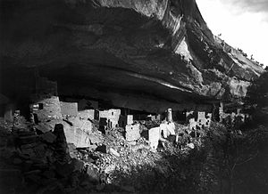
Mesa Verde National Park is a U.S. National Park and UNESCO World Heritage Site located in Montezuma County, Colorado, United States. The park occupies 81.4 square miles (211 square kilometers) near the Four Corners and features numerous ruins of homes and villages built by the ancient Pueblo people known as the Anasazi. The Anasazi made this stone village their home in A.D. 1200s. It is best known for several spectacular cliff dwellings — structures built within caves and under outcroppings in cliffs — including Cliff Palace, which is thought to be the largest cliff dwelling in North America. The Spanish term Mesa Verde translates into English as "green tableland".
Contents |
[edit] Geography
Mesa Verde National Park is located in the lower south-western corner of the state of Colorado
Elevations in the park range from about 6,100 feet (1,860 meters) to about 8,400 feet (2,560 m). The terrain in much of the park is dominated by ridges and valleys running roughly north and south; many of these ridges peak at an east–west crest near the park's northern border which turns more northerly–southerly towards the park entrance. The northernmost point is 13.2 miles (21.2 kilometers) farther north than the southernmost; the westernmost point is 11.9 miles (19.2 kilometers) farther west than the easternmost.
[edit] History
Although explorers from Spain went through the general region in the 18th century, actual sight of the cliffs dwellings by outsiders seems to have first occurred in the latter half of the 19th century. The fame of Mesa Verde soon began to spread thanks to the Wetherill ranchers and the archeological work of Gustaf Nordenskiöld. Vandalism led to the President Teddy Roosevelt's support of protecting the area as a national park in 1906.
[edit] Spanish explorers
Spanish explorers seeking a route from Santa Fe to California in the 1760s and 1770s were the first Europeans to reach the Mesa Verde (green table) region, which they named after its high, tree-covered plateaus. But they never got close enough, or into the needed angle, to see the ancient stone villages, which would remain a secret for another century.
[edit] Richard Wetherill
Occasional trappers and prospectors visited, with one prospector, John Moss, making his observations known in 1873. The following year he led eminent photographer William Henry Jackson through Mancos Canyon, at the base of Mesa Verde. There Jackson both photographed and publicized a typical stone cliff dwelling. In 1875 geologist William H. Holmes retraced Jackson's route. Reports by both Jackson and Holmes were included in the 1876 report of the Hayden Survey, one of the four federally financed efforts to explore the American West. These and other publications led to proposals to systematically study Southwestern archaeological sites. They did not lead to action for some years.
Meanwhile, ranchers were beginning to settle the Mancos Valley. Some climbed up into Mesa Verde and observed more and larger stone structures. Looting of artifacts began, both for home display and for sale cheaply to visitors to the region. In a dismal two decades of despoliation, the most responsible ranchers were members of the Wetherill family, who also had the best relations with the local Ute tribe on whose territory Mesa Verde was located. The Wetherills collected artifacts for sale to the Historical Society of Colorado as well as private collectors, and began assembling a small library of relevant publications. They also saw the tourist potential of the cliff dwellings they now sought out systematically. Over several years they reoriented their ranch toward guiding tourists through the cliff dwellings, and became the first experts on them. Although they continued to dig in the ruins, knocking down some walls and roofs and gathering artifacts without extensive documentation, the Wetherill's actions were more responsible and considerate than those of the looters that preceded them. Modern archaeological opinion generally agrees that the Wetherill family were reasonable caretakers in an era before archaeological standards and federal oversight and protection.[1]

One noteworthy early visitor was a New York newspaper reporter named Virginia McClurg, whose efforts over a period of years helped lead eventually to park status for Mesa Verde. Another, in 1889 and 1890, was photographer and travel writer Frederick H. Chapin. He described the landscape and structures in an 1890 article and 1892 book, The Land of the Cliff-Dwellers, whose many excellent photographs were the first extensive view of Mesa Verde available to the public. Like other visitors in the early years, he was guided by the Wetherills.
[edit] Gustaf Nordenskiöld
Perhaps the most important early visitor was Gustaf Nordenskiöld, son of Finnish-Swedish polar explorer Adolf Erik Nordenskiöld, in 1891. Nordenskiöld, a trained mineralogist, introduced scientific methods to artifact collection, recorded locations, photographed extensively, diagrammed sites, and correlated what he observed with existing archaeological literature as well as the home-grown expertise of the Wetherills.[2]
Local opposition surfaced, however, and, after it was learned that Nordenskiöld's artifacts would be shipped to a museum in northern Europe, he was arrested and charged with "devastating the ruins." Rumors of lynching circulated. Only intervention by several Washington cabinet secretaries freed Nordenskiöld.
On return to Sweden, Nordenskiöld published, in 1893, the first scholarly study of the ruins, The Cliff Dwellers of the Mesa Verde, which put Mesa Verde on the map in the international community. Nordenskiöld's activities remained controversial for many decades but are generally recognized as highly valuable today. Nordenskiöld's collection of Mesa Verde artifacts—in the National Museum of Finland—is the largest outside the U.S. Former Mesa Verde National Park superintendent Robert Heyder summed up Nordenskiöld's contributions:

- I shudder to think what Mesa Verde would be today had there been no Gustaf Nordenskiöld. It is through his book that the cliff dwellings of Mesa Verde became known and his volume might well be called the harbinger of Mesa Verde National Park as we know it today.
[edit] Vandalism
Yet vandalism continued. By the end of the 19th century, it was clear that Mesa Verde needed protection from unthinking or greedy people. An early Mesa Verde National Park superintendent, Hans Randolph, described the situation at the best known cliff dwelling, Cliff Palace:
- Parties of "curio seekers" camped on the ruin for several winters, and it is reported that many hundred specimens therefrom have been carried down the mesa and sold to private individuals. Some of these objects are now in museums, but many are forever lost to science. In order to secure this valuable archaeological material, walls were broken down...often simply to let light into the darker rooms; floors were invariably opened and buried kivas mutilated. To facilitate this work and get rid of the dust, great openings were broken through the five walls which form the front of the ruin. Beams were used for firewood to so great an extent that not a single roof now remains. This work of destruction, added to that resulting from erosion due to rain, left Cliff Palace in a sad condition.
[edit] National park

As concern grew over the archaeological well being of Mesa Verde's ruins, and those in other nearby sites, the area was established as a national park on June 29, 1906. As with all historical areas administered by the National Park Service, the park was listed on the National Register of Historic Places on October 15, 1966. It was designated a World Heritage Site on September 6, 1978. The park was named with the Spanish for green table because of its forests of juniper and piñon trees.
A set of six buildings built by the National Park Service in 1921, the Mesa Verde Administrative District, was designated a National Historic Landmark on May 29, 1987. It consists of the first buildings constructed by the National Park Service which are based on cultural traditions represented in the park area. The principal designer believed that structures could be used for interpretive purposes to explain the construction of prehistoric dwellings in the Park, and be compatible with their natural and cultural setting.
In the summers of 2000 (twice), 2001, 2002, and 2003, the park, which is covered with pinyon pine and utah juniper forests, suffered from a large number of forest fires; parts of it were closed. All areas of the park have since re-opened, but some areas show significant damage from the fires.
[edit] Park services
Mesa Verde's park entrance is about 9 miles (15 kilometers) east of the community of Cortez. The visitor center is 15 miles (24 kilometers) from the entrance, and Chapin Mesa (the most popular area) is another 6 miles (10 kilometers) beyond the visitor center.
The park's Chapin Mesa Archeological Museum provides information about the Ancient Puebloan civilization and displays findings and artwork.

Three of the cliff dwellings on Chapin Mesa are open to the public. Spruce Tree House is open all year, weather permitting. Balcony House and Cliff Palace are open except in the winter; visitors may tour them only on ranger-guided tours. The cliff dwellings on Wetherill Mesa, including Long House and Step House, can be reached via a 12 mile (19.2 kilometer) long mountain road leading southwest from the park visitor center. Many other dwellings are visible from the road but not open to tourists.
In addition to the cliff dwellings, Mesa Verde boasts a number of mesa-top ruins. Examples open to public access include the Far View Complex, Cedar Tree Tower, and the Sun Temple, all on Chapin Mesa, and Badger House Community, on Wetherill Mesa.
Also in the park are hiking trails, a campground, and facilities for food, fuel, and lodging; these are unavailable in the winter.
The Mesa Verde National Park Post Office has the ZIP Code 81330.[3]
[edit] Architecture


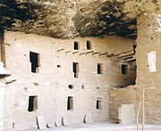
Mesa Verde is best known for a large number of well preserved cliff dwellings, houses built in shallow caves and under rock overhangs along the canyon walls. The structures contained within these alcoves were mostly blocks of hard sandstone, held together and plastered with adobe mortar. Specific constructions had many similarities, but were generally unique in form due to the individual topography of different alcoves along the canyon walls. In marked contrast to earlier constructions and villages on top of the mesas, the cliff dwellings of Mesa Verde reflected a region-wide trend towards the aggregation of growing regional populations into close, highly defensible quarters during the 1200s.
While much of the construction in these sites conforms to common Pueblo architectural forms, including Kivas, towers, and pit-houses, the space constrictions of these alcoves necessitated what seems to have been a far denser concentration of their populations. Mug House, a typical cliff dwelling of the period, was home to around 100 people who shared 94 small rooms and eight kivas built right up against each other and sharing many of their walls; builders in these areas maximized space in any way they could and no areas were considered off-limits to construction [4].
Not all of the people in the region lived in cliff dwellings; many colonized the canyon rims and slopes in multi-family structures that grew to unprecedented size as populations swelled[5]. Decorative motifs for these sandstone/mortar constructions, both cliff dwellings and non-, included T-shaped windows and doors. This has been taken by some archaeologists, such as Stephen Lekson (1999), as evidence of the continuing reach of the Chaco Canyon elite system, which had seemingly collapsed around a century before[6]. Other researchers see these motifs as part of a more generalized Puebloan style and/or spiritual significance, rather than evidence of a continuing specific elite socioeconomic system.[7]
[edit] Notable sites


For most of the 12th and 13th centuries, known archaeologically as the Classic Period, the Ancient Puebloan Indians lived in the cliff dwellings. The reason for their sudden departure about 1275 remains unexplained; theories range from crop failures due to droughts to an intrusion of foreign tribes from the North.
- This ruin is the largest and best-known of the cliff dwellings in Mesa Verde. The site has 150 identified rooms and 23 kivas. Although this and other Mesa Verde sites are large and well constructed, they demonstrate a long history of occupation and their architectural design is an aggregation of dwellings and storage spaces that developed slowly and randomly. Accurate archaeological information from this site has been limited due to several decades of digging and collecting at the turn of the Twentieth century.
- Mug House
- This ruin situated on Wetherill Mesa was professionally excavated in the late 1960s by archaeologist Arthur Rohn. The structure contains 94 rooms, in four levels, including a large kiva, with simple vertical walls and masonry pilasters. This ceremonial structure has a keyhole shape, due to a recess behind the fireplace and a deflector, that is considered an element of the Mesa Verde style. The rooms clustered around the kiva formed part of the courtyard, indicating the kiva would have been roofed.
- Spruce Tree House
- Located on Chapin Mesa, this cliff dwelling is easily accessible and well preserved. The ruins include a kiva with a restored roof which visitors can enter. Excavations indicate that this structure, like many other dwellings in Mesa Verde, was probably occupied for less than a century.
- Square Tower House
- The tower that gives this site its name is the tallest structure in Mesa Verde. This cliff dwelling was occupied between AD 1200 and 1300.
- Mesa Verde Reservoirs
- These ancient reservoirs, built by the Ancient Puebloans, were named a National Civil Engineering Historic Landmark on September 26, 2004.
[edit] See also
- Mesa Verde Wilderness
- Bandelier National Monument
- Canyons of the Ancients National Monument
- Navajo National Monument
- Puye Cliff Dwellings
[edit] References
- FitzGerald, Michael C., "The Majesty of Mesa Verde" in Wall Street Journal, 2009 March 13, p. W12.
- Kantner, John. "Ancient Puebloan Southwest". Cambridge University Press, Cambridge 2004. ISBN-13 9780521788809
- Noble, David Grant. "Ancient Ruins of the Southwest". Northland Publishing, Flagstaff, Arizona 1995. ISBN 0-87358-530-5
- Nordenskiöld, Gustaf. Ruiner af Klippboningar I Mesa Verde's Cañons, Stockholm: P. A. Norstedt & Söner, 1893.
- Nordenskiöld, Gustaf. The Cliff Dwellings of the Mesa Verde, Chicago: P.A. Norstedt & Söner, 1893.
- Oppelt, Norman T. "Guide to Prehistoric Ruins of the Southwest". Pruett Publishing, Boulder, Colorado, 1989. ISBN 0-87108-783-9.
- ^ Reynolds, Judith, Reynolds, David. Nordenskiold of Mesa Verde Xlibris Corporation, April 2006. ISBN 1425704840, paperback.
- ^ FitzGerald, Michael C., "The Majesty of Mesa Verde" in Wall Street Journal, 2009 March 13, p. W12.
- ^ "ZIP Code Lookup" (JavaScript/HTML). United States Postal Service. January 2, 2007. http://zip4.usps.com/zip4/citytown.jsp. Retrieved on January 2 2007.
- ^ Kantner, John (2004). "Ancient Puebloan Southwest", pp. 161-66
- ^ ibid.
- ^ Lekson, Stephen (1999). "The Chaco Meridian: centers of Political Power in the Ancient Southwest". Walnut Creek, Altamira Press
- ^ Phillips, David A., Jr., 2000, "The Chaco Meridian: A skeptical analysis" paper presented to the 65th annual meeting of the Society of American Archaeology, Philadelphia.
[edit] External links
| Wikimedia Commons has media related to: Mesa Verde National Park |
- Mesa Verde National Park (official NPS site)
- Mesa Verde National Park Page
- Mesa Verde Digital Media Archive (creative commons-licensed photos, laser scans, panoramas), data on Spruce Tree House, Fire Temple, and Square Tower House from a Texas Tech University/CyArk research partnership
- Mesa Verde National Park travel guide from Wikitravel
|
|||||||||||
|
|||||||
|

|
||||||||||

