Interstate Highway System
From Wikipedia, the free encyclopedia


The Dwight D. Eisenhower National System of Interstate and Defense Highways, commonly called the Interstate Highway System (or simply, the Interstate System), is a network of limited-access highways (also called freeways or expressways) in the United States that is named for President Dwight D. Eisenhower, who championed its creation. The entire system, as of 2006[update], has a total length of 46,876 miles (75,440 km),[1] making it both the largest highway system in the world and the largest public works project in history.[2] The Interstate Highway System is a subsystem of the National Highway System.
While Interstate Highways usually receive substantial federal funding (90% federal and 10% state) and comply with federal standards, they are owned, built, and operated by the states or toll authorities. For example, the original Woodrow Wilson Bridge (part of Interstate 95 and Interstate 495), was maintained by the federal government; its new span is now jointly owned and maintained by the state of Maryland and the Commonwealth of Virginia.[3] There are also other Interstate Highways within the District of Columbia, which is federal territory.[4]
This expressway system serves nearly all major U.S. cities, with many Interstates passing through downtown areas. The distribution of virtually all goods and services involves Interstate Highways at some point.[5] Residents of American cities commonly use urban Interstates to travel to their places of work. The vast majority of long-distance travel, whether for vacation or business, uses the national road network;[6] of these trips, about one-third (by the total number of miles driven in the country in 2003) use the Interstate system.[7]
Contents |
[edit] History


The Interstate Highway System was authorized by the Federal-Aid Highway Act of 1956[8] – popularly known as the National Interstate and Defense Highways Act of 1956 – on June 29. It had been lobbied for by major U.S. automobile manufacturers and championed by President Dwight D. Eisenhower, who was influenced by his experiences in 1919 as a young Army officer crossing the country in a truck convoy (following the route of the Lincoln Highway), and his appreciation of the German Autobahn network as a necessary component of a national defense system.[9] In addition to facilitating private and commercial transportation, it would provide key ground transport routes for military supplies and troop deployments in case of an emergency or foreign invasion. (Memories were still strong of reported Japanese threats to invade the West Coast of the U.S. during World War II.)
Initial federal planning for a nationwide highway system began in 1921, when the Bureau of Public Roads asked the Army to provide a list of roads it considered necessary for national defense. This resulted in the Pershing Map.[10] Later that decade, highways such as the New York parkway system were built as part of local or state highway systems. As automobile traffic increased, planners saw a need for such an interconnected national system to supplement the existing, largely non-freeway, United States Numbered Highway system. By the late 1930s, planning had expanded to a system of new superhighways. In 1938, President Franklin D. Roosevelt gave BPR chief Thomas MacDonald a hand-drawn map of the U.S. marked with eight superhighway corridors for study.[10] The publication General Location of National System of Interstate Highways maps out what became the Interstate System, and is informally known as the Yellow Book.[11]
Although construction on the Interstate Highway System continues, I-70 through Glenwood Canyon (completed in 1992) is often cited as the completion of the originally-planned system.[12][13] The initial cost estimate for the system was $25 billion over 12 years; it ended up costing $114 billion (adjusted for inflation, $425 billion in 2006 dollars[14]) and taking 35 years to complete.[15] Additional spurs and loops/bypasses remain under construction, such as Interstate 485 in North Carolina. A few main routes not part of the original plan remain under construction, such as Interstate 22 in Alabama, Mississippi, and Tennessee.
Due to the cancellation of the Somerset Freeway, Interstate 95 is discontinuous in New Jersey. When the Pennsylvania Turnpike/Interstate 95 Interchange Project concludes in or around 2009[dated info], the last section of the original plan will be completed.[16]
Three states have claimed the title of first Interstate Highway. Missouri claims that the first three contracts under the new program were signed in Missouri on August 2, 1956. The first contract signed was for U.S. 66 (now I-44). On August 13, 1956, Missouri awarded the first contract based on new Interstate Highway funding.[17]
Kansas claims that it was the first to start paving after the act was signed. Preliminary construction had taken place before the act was signed, and paving started September 26, 1956. The state marked its portion of I-70 as the "first project in the United States completed under the provisions of the new Federal-Aid Highway Act of 1956."[17]
According to information liaison specialist, Richard Weingroff, the Pennsylvania Turnpike could also be considered one of the first Interstate Highways. On October 1, 1940, 162 miles (261 km) of the highway now designated I-70 and I-76 opened between Irwin and Carlisle. The state of Pennsylvania refers to the turnpike as "The Granddaddy of the Pikes".[17]
[edit] Standards
The American Association of State Highway and Transportation Officials (AASHTO) has defined a set of standards that all new Interstates must meet unless a waiver from the Federal Highway Administration (FHWA) is obtained. One almost absolute standard is the controlled access nature of the roads. With few exceptions, traffic lights (and cross traffic in general) are limited to toll booths and ramp meters (metered flow control for lane merging during rush hour).
[edit] Speed limits
Being freeways, Interstate Highways usually have the highest speed limits in a given area. Speed limits are determined by individual states. From 1974 to 1987, the maximum speed limit on any highway in the United States was 55 miles per hour, in accordance with federal law. Currently, rural speed limits generally range from 65 to 75 miles per hour (105–120 km/h), although several portions of I-10 & I-20 in rural western Texas, along with a portion of I-15 in rural central Utah, have speed limits of 80 mph (130 km/h). Typically, lower limits are established in the more densely populated Northeastern states, while higher speed limits are established in the less densely populated Southern and Western states.[18]
[edit] Other uses
As one of the components of the National Highway System, Interstate Highways improve the mobility of military troops to and from airports, seaports, rail terminals and other military bases. Interstate Highways also connect to other roads that are a part of the Strategic Highway Network, a system of roads identified as critical to the U.S. Department of Defense.[19]
The system has also been used to facilitate evacuations in the face of hurricanes and other natural disasters. An option for maximizing traffic throughput on a highway is to reverse the flow of traffic on one side of a divider so that all lanes become outbound lanes. This procedure, known as contraflow lane reversal, has been employed several times for hurricane evacuations. After public outcry regarding the inefficiency of evacuating from southern Louisiana prior to Hurricane Georges' landfall in September 1998, government officials looked towards contraflow to improve evacuation times. In Savannah, Georgia and Charleston, South Carolina in 1999, lanes of Interstates 16 and 26 were used in a contraflow configuration in anticipation of Hurricane Floyd, with mixed results.[20]
In 2004, contraflow was employed ahead of Hurricane Charley in the Tampa, Florida area and on the Gulf Coast before the landfall of Hurricane Ivan;[21] however, evacuation times there were no better than previous evacuation operations. Engineers began to apply lessons learned from the analysis of prior contraflow operations, including limiting exits, removing troopers (so as to keep traffic flowing, instead of having drivers stop for directions), and improving the dissemination of public information. As a result, the 2005 evacuation of New Orleans, Louisiana prior to hurricane Katrina ran far more "smoothly".[22]
A widespread urban legend states that one out of every five miles of the Interstate Highway System must be built straight and flat so as to be usable by aircraft during times of war. Contrary to popular lore, Interstate Highways are not designed to serve as airstrips.[23][24]
[edit] Terminology
While the name implies that Interstate Highways cross state lines, many do not (for details, see List of intrastate Interstates). Rather, they are funded federally with money shared among the states. There are Interstate Highways in Hawaii, funded in the same way as in the other states, but entirely within the populous island of Oahu. They have the designation of H-x and connect military bases, though they are open to public use. Both Alaska and Puerto Rico have public roads that receive funding from the Interstate program, although these routes are not signed as Interstate Highways (except on paper). These roads are neither planned for, nor built to, official Interstate Highway standards.
[edit] Primary routes
The numbering scheme for the Interstate Highway System (as well as the U.S. Highway System) was developed in 1957 by the American Association of State Highway and Transportation Officials (AASHTO). The association's latest numbering policy dates back to August 10, 1973.[25] Within the continental United States, primary Interstates – also called main line Interstates or two-digit Interstates – are assigned numbers less than 100. AASHTO policy discourages Interstate and U.S. highways having the same number within the same state, although there are a few exceptions.[25]
Within this category, east–west highways are assigned even numbers, and north–south highways are assigned odd numbers. Odd route numbers increase from west to east, and even-numbered routes increase from south to north, though there are exceptions to both principles in several locations. Numbers divisible by 5 are intended to be major arteries among the primary routes, carrying traffic long distances.[10][26] Major north–south arterial Interstates increase in number from I-5 between Canada and Mexico along the West Coast to I-95 between Miami and Canada along the east coast. Major east–west arterial Interstates increase in number from I-10 between Santa Monica, California and Jacksonville, Florida to I-90 between Seattle and Boston. Two-digit Interstates in Hawaii, as well as the "paper" Interstates of Alaska and Puerto Rico, are numbered sequentially in order of funding, without regard to the rules on odd and even numbers.
Several two-digit numbers are shared between two roads at opposite ends of the country (I-76, I-84, and I-86). Some of these were the result of a change in the numbering system as a result of the new policy adopted in 1973. Previously, letter-suffixed numbers were used for long spurs off primary routes; for example, western I-84 was I-80N, as it went north from I-80. The new policy stated that "No new divided numbers (such as I-35W and I-35E, etc.) shall be adopted." The new policy also recommended that existing divided numbers be eliminated as quickly as possible; however, I-35W and I-35E still exist near the Twin Cities of Minneapolis and Saint Paul in Minnesota and the Metroplex in Fort Worth and Dallas in Texas.[25]
AASHTO policy allows dual numbering so as to provide continuity between major control points.[25] This is usually referred to as a concurrency or overlap. For example, I-75 from Chattanooga, Tennessee to Macon, Georgia and I-85 from Greenville, South Carolina to Montgomery, Alabama share the same roadway (the Downtown Connector) in Atlanta. As a result, this section of Interstate Highway is labeled both I-75 and I-85. Concurrencies between Interstate and U.S. Route numbers are also allowed per AASHTO policy, so long as the length of the concurrency is "reasonable".[25] The concurrency policy may lead to confusion when two routes on the same roadway are marked in opposite directions. This is called a wrong-way concurrency. An example of a wrong-way concurrency is the stretch of I-80 and I-580 in California between Emeryville and Richmond; I-80 east and I-580 west are equivalent (likewise, I-80 west and I-580 east).
[edit] Auxiliary Interstates
Auxiliary Interstate Highways are circumferential, radial, or spur highways that principally serve urban areas. These types of Interstate Highways are given three-digit route numbers, which consist of a single digit prefixed to the two-digit number of a nearby primary Interstate Highway. Spur routes deviate from their parent and do not return, with a few exceptions; these are given an odd first digit. Circumferential and radial loop routes return to Interstate Highways, and are given an even first digit. Due to the large number of these routes, auxiliary route numbers may be repeated in different states along the mainline.[27] Some auxiliary highways do not follow these guidelines, however. See List of auxiliary Interstate Highways for examples.
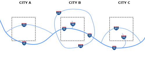
In the example above, City A has an even-numbered circumferential highway. City B has an even-numbered circumferential beltway and an odd-numbered spur. City C has an even-numbered circumferential highway and an odd numbered spur. Because cities A, B and C are in the same state, each auxiliary route carries a distinct three-digit route number.[27]
Unlike primary Interstates, three-digit Interstates are signed as either east/west or north/south, depending on the general orientation of the route, without regard to the route number. For some looped Interstate routes, inner/outer directions are used as a directional labeling system, as opposed to compass directions.
[edit] Business routes
AASHTO defines a category of special routes separate from primary and auxiliary Interstate designations. These routes do not have to comply to Interstate construction standards, but are routes that may be identified and approved by the association. The same route marking policy applies to both U.S. Numbered Highways and Interstate Highways; however, business route designations are sometimes used for Interstate Highways.[28] Known as Business Loops and Business Spurs, these routes that principally travel through the corporate limits of a city, passing through the central business district of the city. Business routes are used when the regular route is directed around the city.[28]
[edit] Financing

About 56% of the construction and maintenance costs are funded through user fees, primarily gasoline taxes collected by the federal government and state and local governments, and tolls collected on toll roads and bridges. The rest of the costs are borne by general fund receipts, bond issues, and designated property and other taxes. The federal contribution is overwhelmingly (93.5% in 2003) from motor vehicle and fuel taxes, as is over two-thirds of the state contribution. However, local contributions are overwhelmingly from sources other than user fees.[29] In addition, some portion of the user fees are diverted to other programs, prominently including mass transit. In the eastern United States, large sections of some Interstate Highways planned or built prior to 1956 are operated as toll roads.
As American suburbs have expanded, the costs incurred in maintaining freeway infrastructure have also grown, leaving little in the way of funds for new Interstate construction.[30] This has led to the proliferation of toll roads (turnpikes) as the new method of building limited-access highways in suburban areas. Some Interstates are privately maintained (e.g., VMS maintains I-35 in Texas)[31] to meet rising costs of maintenance and allow state departments of transportation to focus on serving the fastest growing regions in their respective states.
Parts of the system may have to be tolled in the future to meet maintenance and expansion demands, as has been done with adding toll HOV/HOT lanes in cities such as San Diego, Salt Lake City, Minneapolis, Houston, Denver, Dallas, Atlanta,[32][33] and Washington, D.C. At present, federal law does not allow for a state to change a freeway section to a tolled section for all traffic.[citation needed]
[edit] Local maintenance
A few Interstates are maintained by local authorities:
- Baltimore, Maryland: Interstate 70 and Interstate 83 in the city limits[34]
- New York City: Small portions of Interstate 278[35]
- Washington, D.C.: Because the city and District are identical, the District maintains the portions of Interstate 66, Interstate 295, Interstate 395 and Interstate 695 inside the city.
- Las Vegas: Much of Interstate 215 is managed by Clark County, Nevada's public works department. Only about four miles (6 km) of the freeway were turned over to the Nevada Department of Transportation after the road was completed.
[edit] Chargeable and non-chargeable Interstate routes
Interstate Highways financed with federal funds are known as "chargeable" Interstate routes, and are considered part of the 42,000-mile (68,000 km) network of highways. Federal laws[36] allow highways funded similarly to state and U.S. highways to be signed as Interstates, if they meet the Interstate Highway standards and are logical additions or connections to the system.[37]
Called "non-chargeable" Interstate routes, these additions fall under two categories: routes that already meet Interstate standards, and routes not yet upgraded to Interstate standards. Only routes that meet Interstate standards may be signed as Interstates once their proposed number is approved.
[edit] Signage
The majority of Interstates have exit numbers. All traffic signs and lane markings on the Interstates are supposed to be designed in compliance with the Manual on Uniform Traffic Control Devices (MUTCD). However, there are many local and regional variations in signage.
For many years, California was the only state that did not use an exit numbering system. It was granted an exemption in the 1950s due to having an already largely completed and signed highway system; at the time, placing exit number signage across the state was deemed too expensive. Since 2002, however, California has begun to incorporate exit numbers on all its freeways – Interstate, U.S., and state routes alike. To mitigate costs, Caltrans commonly installs exit number signage only when a freeway or interchange is built, reconstructed, retrofitted, or repaired. The majority of the exits along California's Interstates now have exit number signage, particularly in rural areas.[citation needed]
In most states, the exit numbers correspond to the mileage markers on the Interstates. However, on I-19 in Arizona, length is measured in kilometers instead of miles, in part because the road runs south to the Mexican border. On most even-numbered Interstates, mileage count increases from west to east; on odd-numbered Interstates, mileage count increases from south to north. Some tollways, including the New York State Thruway and Jane Addams Memorial Tollway, use radial exit numbering schemes. Exits on the New York State Thruway count up from Yonkers traveling north, and then west from Albany. On the Jane Addams Memorial Tollway, mileage markers count up from Chicago-O'Hare International Airport traveling west.
Many northeastern states label exit numbers sequentially, regardless of how many miles have passed between exits. States in which Interstate exits are still numbered sequentially are Connecticut, Delaware, Massachusetts, New Hampshire, New York, Rhode Island and Vermont. Maine, Pennsylvania, Virginia, Georgia and Florida followed this system for a number of years, but recently converted to mileage-based exit numbers. The Pennsylvania Turnpike uses both mile marker numbers and sequential numbers. Mile marker numbers are used for signage, while sequential numbers are used for numbering interchanges internally. The New Jersey Turnpike also has sequential numbering, but other Interstates within New Jersey generally use mile markers.
[edit] Interstate shield
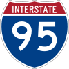
Interstate Highways are signed by a number placed on a trademarked[10][38] red, white and blue sign. An example Interstate 95 sign is shown to the right. In the original design, the state was listed above the highway number, but in many states, this area is now left blank. The sign usually measures 36-in (91 cm) high, and is 36-in wide for two-digit Interstates or 45-in (114 cm) for three-digit Interstates.[39]
Interstate business loops and spurs use a special shield where the red and blue are replaced with green, the word BUSINESS appears instead of INTERSTATE, and the word SPUR or LOOP usually appears above the number.[40]
Over time, the design of the Interstate shield has changed. In 1958, the Interstate shield designed by Texas Highway Department employee Richard Oliver was introduced, the winner of a contest which included 100 entries;[41][42] at the time, the shield color was a dark navy blue and only 17-in (41 cm) wide.[39] The MUTCD standards revised the shield in the 1961, 1972, 1988, and 2000 editions. By 2000, the shield size nearly doubled, with some Interstate shields reaching 36 inches (910 mm) in width.
[edit] Extremes
The extremes in traffic volume:
- Heaviest traveled section: 390,000 vehicles a day: Interstate 405 in Los Angeles, California (2006 estimate[43]).
- Least traveled section: 1,800 vehicles a day: Interstate 95 just north of Houlton, Maine to the Canadian border (2001 estimate[44]).
The extremes in each direction:
- Northernmost: The northern termini of Interstates 5, 15, and 29, crossing the Canadian border at the 49th parallel near, respectively, Blaine, Washington; Sweetgrass, Montana; and Pembina, North Dakota. The A-2 and A-4 highways in Alaska are farther north, but are unsigned as Interstates and are not up to normal Interstate standards.
- Southernmost: A bend on Interstate H-1 in the Kaimuki section of Honolulu, Hawaii, less than 1/2 mile (0.8 km) before its eastern terminus (lat. 21.3 deg. N.). The southernmost point in the 48 contiguous states is the southern terminus of Interstate 95 in Miami, Florida (lat. 25.8 deg. N.).
- Easternmost: The northern terminus of Interstate 95 near Houlton, Maine, at the border of New Brunswick in Canada (long. 67.8 deg. W.).
- Westernmost: The western terminus of Interstate H-1 in Kapolei, Hawaii (long. 158.06 deg. W.). The westernmost point in the contiguous states is a curve on Interstate 5 near Wolf Creek, Oregon (long. 123.23 deg. W.).
The extremities in elevation:
- Highest: Interstate 70 (11,158 ft/3,401 m) in the Eisenhower Tunnel at the Continental Divide in the Colorado Rocky Mountains.
- Lowest (on land): Interstate 8 (−52 ft/−16 m) at the New River near Seeley, California.
- Lowest (under water): Interstate 95 (−107 ft/−33 m) in the Fort McHenry Tunnel under the Inner Harbor in Baltimore, Maryland.
The extremes in length:
- The longest Interstate Highway is Interstate 90, which runs 3,099 miles (4,987 km) between Boston, Massachusetts and Seattle, Washington.
- The longest north-south Interstate Highway is generally cited as Interstate 95; when completed, it will run 1,927 miles (3,101 km) between Miami, Florida and the Canadian border (there is a gap in New Jersey).
- The shortest (albeit unsigned) Interstate is Interstate 878, a 0.7-mile (1.1 km) portion of New York State Route 878 adjacent to John F. Kennedy International Airport in Queens, New York. Another short unsigned Interstate is Interstate 110 near downtown El Paso, with a length of 0.92 miles (1.48 km).
- The shortest signed Interstate is Interstate 375 in downtown Detroit, Michigan, at 1.06 miles (1.71 km).The shortest two-digit Interstate Highway is Interstate 97, running from Baltimore, Maryland to Annapolis, Maryland.This highway is 17.62 miles (28.36 km).
- The shortest Interstate route segment within a state (or federal district) is 0.11 miles (0.18 km) of I-95 in the District of Columbia, where it crosses the Potomac River on the Woodrow Wilson Bridge.[45]
The extremes in width:
- As of 2004, a section of I-75 north of Atlanta, near the interchange with Interstate 285, has 15 lanes, making it the widest section of the Interstate System.[46]
- The section of Interstate 93 in New Hampshire that runs through Franconia Notch State Park and the southern span of the Thousand Islands Bridge, which carries Interstate 81, are the only instances of a two lane highway – also called a Super-2 parkway – on the Interstate system, although some 2-lane International crossings over water are cited as the political end of some Interstates such as Interstate 75.
[edit] See also
- Adopt a Highway
- Highway patrol
- International E-road network in Europe
- List of highway systems with full control of access and no cross traffic
- List of roads and highways
- Non-motorized access on freeways
- Parkway
- Transportation in the United States
- National Highway System
[edit] References
- ^ "Interstate FAQ (Question #3)". Federal Highway Administration (an agency of the United States Department of Transportation). 2006. http://www.fhwa.dot.gov/interstate/faq.htm#question3. Retrieved on 2009-03-04.
- ^ "The Year of the Interstate". http://www.tfhrc.gov/pubrds/06jan/01.htm. Retrieved on 2008-04-29.
- ^ "Attachment V, Ownership and Maintenance Agreement for the Wilson Bridge, Woodrow Wilson Bridge Initial Financial Plan" (PDF). Woodrow Wilson Bridge Project. http://www.wilsonbridge.com/financial%20plan/august%202001%20initial%20financial%20plan%20-%20attachment%20v.pdf. Retrieved on 2007-08-02.
- ^ See Interstate 295 and Interstate 395.
- ^ Caltrans (2006). "The Interstate Highway System Turns 50". http://www.dot.ca.gov/interstate/. Retrieved on 2008-01-10.
- ^ "Table 1-36: Long-Distance Travel in the United States by Selected Trip Characteristics". Bureau of Transportation Statistics. 1995. http://www.bts.gov/publications/national_transportation_statistics/2002/html/table_01_36.html. Retrieved on 2006-12-21.
- ^ "Annual Vehicle Distance Traveled in Miles and Related Data". Federal Highway Administration. 2003. http://www.fhwa.dot.gov/policy/ohim/hs03/htm/vm1.htm. Retrieved on 2006-12-21.
- ^ "The cracks are showing". The Economist. 2008-06-26. http://www.economist.com/world/unitedstates/displayStory.cfm?story_id=11636517. Retrieved on 2008-10-23.
- ^ Petroski, Henry (2006), "On the Road", American Scientist 94 (5): pp. 396-399
- ^ a b c d McNichol, Dan. The Roads that Built America: The Incredible Story of the U.S. Interstate System. New York: Sterling Publishing Co., Inc., 2006. ISBN 1-4027-3468-9
- ^ Norton, Peter (1996). "Fighting Traffic: U.S. Transportation Policy and Urban Congestion, 1955-1970". Essays in History (Corcoran Department of History at the University of Virginia). http://etext.virginia.edu/journals/EH/EH38/Norton.html. Retrieved on 2008-01-17.
- ^ "CDOT Fun Facts". Colorado Department of Transportation. http://www.dot.state.co.us/50anniversary/funfacts.cfm. Retrieved on 2008-02-15.
- ^ Karen Stufflebeam Row, Eva LaDow, and Steve Moler. "Glenwood Canyon 12 Years Later". United States Department of Transportation - Federal Highway Administration. http://www.tfhrc.gov/pubrds/04mar/04.htm.
- ^ Neuharth, Al (2006-06-23). "Traveling interstates is our sixth freedom". USA TODAY.
- ^ Minnesota Department of Transportation (2006). "Mn/DOT celebrates Interstate Highway System's 50th anniversary". http://www.dot.state.mn.us/interstate50/50facts.html. Retrieved on 2008-01-17.
- ^ Pennsylvania Turnpike Commission. "I-95/I-276 Interchange Project Meeting Design Management Summary - DRAFT: Design Advisory Committee Meeting #2" (PDF). http://www.paturnpikei95.com/pdf/DACMeeting050914.pdf.
- ^ a b c Weingroff, Richard F. (2005-05-07). "Three States Claim First Interstate Highway". Federal Highway Administration. http://www.fhwa.dot.gov/infrastructure/rw96h.htm. Retrieved on 2008-02-16.
- ^ Carr, John (2007-10-11). "State traffic and speed laws". http://www.mit.edu/~jfc/laws.html. Retrieved on 2008-01-10.
- ^ Slater, Rodney E. (Spring 1996). "The National Highway System: A Commitment to America's Future". http://www.tfhrc.gov/pubrds/spring96/p96sp2.htm. Retrieved on 2008-01-10.
- ^ Wolshon, Brian, P.E. (August 2001). ""One-Way-Out": Contraflow Freeway Operation for Hurricane Evacuation". http://www.google.com/url?sa=t&ct=res&cd=3&url=http%3A%2F%2Fwww.asce.org%2Ffiles%2Fpdf%2Fhurricane%2FEvacuation_and_Shelters%2FOne_Way_Out~Contraflow_Freeway_Operation_for_Hurricane_Evacuation.pdf&ei=p2eGR87TB5ngiAHs1cTzBA&usg=AFQjCNHdMFt9MMBYGRtxh6dx3hucEK6hTw&sig2=8GG0G3JHXyG7rIsspWiXbQ. Retrieved on 2008-01-10.
- ^ Florida Department of Transportation. "Contraflow Implementation Experiences in the Southern Coastal States" (PDF). http://www.floridaits.com/PDFs/TWO60-Contraflow/060330-Experiences-V2.pdf. Retrieved on 2007-09-27.
- ^ McNichol, Dan (December 2006). "Contra Productive". Roads & Bridges. http://www.roadsbridges.com/popup_app/index.cfm?fuseaction=showArticle&appDirectory=rb&articleID=7519&forPrint=yes. Retrieved on 2008-01-10.
- ^ Landing of Hope and Glory, snopes.com, http://www.snopes.com/autos/law/airstrip.asp, retrieved on 2007-12-30
- ^ Weingroff, Richard F. (May/June 2000). "ONE MILE IN FIVE: Debunking the Myth". Federal Highway Administration. http://www.tfhrc.gov/pubrds/mayjun00/onemileinfive.htm. Retrieved on 2006-06-29.
- ^ a b c d e AASHTO (January 2000). "Establishment of a Marking System of the Routes Comprising the National System of Interstate and Defense Highways" (PDF). http://cms.transportation.org/sites/route/docs/HO2_Policy_Retention_HO1.pdf. Retrieved on 2008-01-23.
- ^ The Rambler (2005-01-18). "Ask the Rambler: Was I-76 Numbered to Honor Philadelphia for Independence Day, 1776?". Federal Highway Administration. http://www.fhwa.dot.gov/infrastructure/i76.htm. Retrieved on 2008-01-17.
- ^ a b Federal Highway Administration (2007-03-22). "FHWA Route Log and Finder List". http://www.fhwa.dot.gov/reports/routefinder/index.cfm. Retrieved on 2008-01-23.
- ^ a b AASHTO (January 2000). "Establishment and Development of United States Numbered Highways" (PDF). http://cms.transportation.org/sites/route/docs/HO1_Policy_Establ_Develop_USRN.pdf. Retrieved on 2008-01-23.
- ^ "2003 FHWA summary". http://www.fhwa.dot.gov/policy/ohim/hs03/htm/hf10.htm. Retrieved on 2008-11-05.
- ^ Field, David. "On 40th birthday, interstates face expensive midlife crisis." Insight on the News, 29 July 1996, 40-42.
- ^ VMS, Inc.. "Projects by Type". http://www.vmsom.com/projectsoverviewbytype.shtm#Interstates. Retrieved on 2008-01-10.
- ^ Ariel Hart. "1st toll project proposed for I-20 east. Plan would add lanes outside I-285" (PDF). Atlanta Journal-Constitution. http://www.cobbrides.com/pdfs/1st%20toll%20project%20proposed%20for%20I.pdf. Retrieved on 2007-09-27.
- ^ Darryl D. VanMeter. "Future of HOV in Atlanta" (PDF). http://www.dot.state.ga.us/preconstruction/consultantdesign/design/Future%20of%20HOV%20in%20Atlanta.pdf. Retrieved on 2007-09-27.
- ^ Maryland's Interstate SystemPDF (18.6 KB)
- ^ New York State Department of Transportation - Region 11 (New York City) Built and Unbuilt Arterial System
- ^ 23 U.S.C. § 103–4
- ^ California Highways: Interstate Highway Types and the History of California's Interstates
- ^ Manual on Uniform Traffic Control Devices, Introduction. Trademark has Serial Number 72239199, Registration Number 0835635.
- ^ a b Interstate Shield Galleries
- ^ Index of Interstate Business Loops
- ^ "Ties to Texas" Texas Transportation Researcher newsletter, Volume 41, Number 4 (2005), Texas Transportation Institute.
- ^ The Interstate is 50: Image Gallery. AASHTO.
- ^ Most Travelled Urban Highways Average AADT
- ^ Interstate 95 Annual Average Daily Traffic (AADT)
- ^ Interstate Route Numbering
- ^ "Interstate System Facts". Highway Information Quarterly Newsletter (Federal Highway Administration). January 2004. http://www.fhwa.dot.gov/policy/ohpi/hiqjan04.htm. Retrieved on 2008-11-26.
[edit] External links
| Wikimedia Commons has media related to: Interstate Highways |
- Interstate Highway information
- FHWA Route Log and Finder List
- FHWA Turner-Fairbank Highway Research Center
- U.S. President's Advisory Committee on a National Highway System Records, 1954-1955, Dwight D. Eisenhower Presidential Library
- Documents regarding the Interstate Highway System, Dwight D. Eisenhower Presidential Library
| Main Interstate Highways (multiples of 5 highlighted) | |||||||||||||||||||
|---|---|---|---|---|---|---|---|---|---|---|---|---|---|---|---|---|---|---|---|
| 4 | 5 | 8 | 10 | 12 | 15 | 16 | 17 | 19 | 20 | 22 | 24 | 25 | 26 | 27 | 29 | 30 | |||
| 35 | 37 | 39 | 40 | 43 | 44 | 45 | 49 | 55 | 57 | 59 | 64 | 65 | 66 | 68 | 69 | ||||
| 70 | 71 | 72 | 73 | 74 | 75 | 76 (W) | 76 (E) | 77 | 78 | 79 | 80 | 81 | 82 | ||||||
| 83 | 84 (W) | 84 (E) | 85 | 86 (W) | 86 (E) | 87 | 88 (W) | 88 (E) | 89 | 90 | |||||||||
| 91 | 93 | 94 | 95 | 96 | 97 | 99 | (238) | H-1 | H-2 | H-3 | |||||||||
| Unsigned | A-1 | A-2 | A-3 | A-4 | PRI-1 | PRI-2 | PRI-3 | ||||||||||||
| Lists | Primary | Main - Intrastate - Suffixed - Future - Gaps | |||||||||||||||||
| Auxiliary | Main - Future - Unsigned | ||||||||||||||||||
| Other | Standards - Business - Bypassed | ||||||||||||||||||
|
|||||||||||

