Jesusland map
From Wikipedia, the free encyclopedia
The Jesusland map is an Internet meme, created shortly after the 2004 United States Presidential election, which satirizes the red/blue states scheme.
Contents |
[edit] Origin
The original image was created on November 3, 2004 by G. Webb, a poster on yakyak.org, an Internet message board for fans of the work of Jeff Minter (see the original discussion).
[edit] Geography
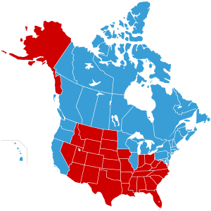
The meme is in the form of a map of the U.S. and Canada which depicts a new hypothetical national border between the two countries. The "blue states" from the 2004 election have been merged with Canada to form a single contiguous nation, which is labeled the "United States of Canada." The remaining "red states" are labeled as "Jesusland".
The map's appearance highlights the fact that the "red states" (except Alaska) are all contiguous with one another, while the continental "blue states" are also contiguous when combined with Canada.
[edit] Variations

Similar maps give different labels to the geographically separated blue states. The northeastern states are alternately referred to as "Eastern Realitania", "Northeastistan", "Western France", "The New American Republic", or "New America";[1] the central blue states near the Great Lakes are labeled "Central Realitania" or "Minniwillinois"; and the blue states along the Pacific Coast are called "Western Realitania", "Pacificstan", "Southern Canada" or "Baja Canada" (with Hawaii being separately labeled "The Tropic of Canada"). Another has chosen the overall name "Realistan", and another has chosen "The United States of Liberty and Education". The red states in these variant maps are called "Jesusistan", "Redstateistan", "Redneckistan",[1] the "United States of Evangelicals",[2] "the United State of Texas", or in the most extreme case, "Dumbfuckistan" (referenced by a December 18, 2004 TV Funhouse cartoon on Saturday Night Live[3]). Some maps purport to show a capital city of Crawford, Texas, the home of former U.S. President George W. Bush. One map shows Alaska as having been returned to Russia.
The Canadian province of Alberta, which has historically voted for the Conservative Party of Canada or its antecedents,[4] is sometimes included in Jesusland and is contiguous with the continental U.S. "red" states.
A future polity entitled the "Republic of Northern America" is posited as a result of disenchantment and growing irritation between the Northern and Southern U.S. states, leading the former to seek a union with Canadian provinces.[5]
[edit] Analysis

In the context of the Jesusland map, the states in which a majority voted Democratic in the 2004 election are viewed as more socially liberal in outlook, and therefore having more cultural similarities with Canada than with the remainder of the United States. The Republican-voting red states tended to vote based more on what they referred to as moral values, such as opposition to same-sex marriage and embryonic stem cell research.[6] Holders of these values are characterized by a high degree of faith in Evangelical Christianity, thus causing the name of Jesus to be affixed to the hypothetical country;[7] in an article by Ron Suskind of the New York Times, a Republican official characterized the divide as being one between a "faith-based community" and a "reality-based community."
The gap is seen as stark enough that some Democratic bloggers have ironically or semi-seriously advocated secession, whilst some on the Republican side (such as Mike Thompson, a past chairman of the Florida American Conservative Union) suggested that the federal government expel the blue states.[8] To that end, some have noted the similarity between the electoral map of the U.S. in 2004 and a map of the United States in 1860, showing the free and slave states prior to the American Civil War.[9]
[edit] Jesusland in popular culture
|
|
This section does not cite any references or sources. Please help improve this article by adding citations to reliable sources (ideally, using inline citations). Unsourced material may be challenged and removed. (April 2009) |
- The map has been reproduced on postcards, clothes, bags, and mugs.[citation needed]
- Paul Auster's novel Man in the Dark (2008) presents a dystopian scenario of the present-day United States being torn apart by a new secession and civil war after the presidential elections of 2000. The fictional division between the book's Secessionist and Loyal states is very similar, respectively, to the Blue and Red states of Jesusland maps, though the term is not explicitly mentioned.[citation needed]
- Richard K. Morgan's science fiction novel Black Man (2007) (published as Thirteen in the United States) contains a similar secession between the Union and Jesusland.[citation needed]
- American rock pianist Ben Folds included a song called "Jesusland" on his 2005 album Songs for Silverman.
- The American punk band NOFX's song "Leaving Jesusland", from their 2006 album Wolves in Wolves' Clothing, makes reference to liberals moving from the South and going to California.[citation needed]
[edit] See also
- Canada and the 2004 United States presidential election
- Nine Nations of North America
- Soviet Canuckistan
[edit] References
- ^ a b http://vegasmusictalk.com/images/usa3waysplit.gif
- ^ Muslim WakeUp! A Possible Solution to US Electoral Problems
- ^ Media Sluts: Drunken Weekend, Lotsa O.C
- ^ [1]
- ^ Kelly, Stéphane. "The Republic of Northern America." Toronto Star; Opinion (Canada 2020). 26 December 2006.
- ^ Exit poll - Decision 2004 - MSNBC.com
- ^ Weblog: 'Moral Values' Carry Bush to Victory | Christianity Today | A Magazine of Evangelical Conviction
- ^ Human Events
- ^ http://archive.michiganimc.org/usermedia/image/7/large/election%202004%202%20maps%202f6760.JPG

