Arrondissements of Paris
From Wikipedia, the free encyclopedia
| Arrondissement of Paris | |
|---|---|
| Administration | |
| Country | France |
| Region | Île-de-France |
| Department | Paris |
| Cantons | 20 |
| Communes | 1 |
| Préfecture | Paris |
| Statistics | |
| Land area¹ | 105 km² |
| Population | |
| - 1999 | 2,125,246 |
| - Density | 20240/km² |
| Location | |
| ¹ French Land Register data, which exclude lakes, ponds, and glaciers larger than 1 km² (0.386 sq. mi. or 247 acres) as well as the estuaries of rivers. | |
The City of Paris is divided into twenty arrondissements municipaux, more simply referred to as arrondissements (pronounced /əˈɹɒndɨsmənt/ in English and /aʁɔ̃dismɑ̃/ in French). These are not to be confused with departmental arrondissements, which subdivide the one hundred French départements. The word "arrondissement", when applied to Paris, refers almost always to the municipal arrondissements listed below. The number of the arrondissement is indicated by the last two digits in Parisian postal codes (75001 up to 75020).
Contents |
[edit] Description
The twenty arrondissements are arranged in the form of a clockwise spiral, starting with the first in the middle of the city on the right bank (north bank) of the Seine. The French cities of Lyon and Marseille are also subdivided in this way. The way the Arrondissements are spiralled corresponds with the shape of a snail (in French an Escargot).
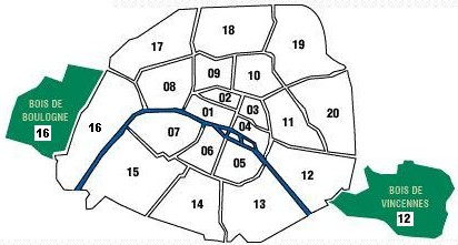

The list below indicates Right Bank (R) or Left Bank (L) bank:
| Arrondissement | Name | Area (in km²) | Population (March 1999 census) |
Population (July 2005 estimate) |
Density (2005) (inh. per km²) |
Peak of population |
|---|---|---|---|---|---|---|
| 1st R | Louvre | 1.826 | 16,888 | 17,700 | 9,693 | before 1861 |
| 2nd R | Bourse | 0.992 | 19,585 | 20,700 | 20,867 | before 1861 |
| 3rd R | Temple | 1.171 | 34,248 | 35,100 | 29,974 | before 1861 |
| 4th R | Hôtel-de-Ville | 1.601 | 30,675 | 28,600 | 17,864 | before 1861 |
| 5th L | Panthéon | 2.541 | 58,849 | 60,600 | 23,849 | 1911 |
| 6th L | Luxembourg | 2.154 | 44,919 | 45,200 | 20,984 | 1911 |
| 7th L | Palais-Bourbon | 4.088 | 56,985 | 55,400 | 13,552 | 1926 |
| 8th R | Élysée | 3.881 | 39,314 | 38,700 | 9,972 | 1891 |
| 9th R | Opéra | 2.179 | 55,838 | 58,500 | 26,847 | 1901 |
| 10th R | Enclos-St-Laurent | 2.892 | 89,612 | 88,800 | 30,705 | 1881 |
| 11th R | Popincourt | 3.666 | 149,102 | 152,500 | 41,598 | 1911 |
| 12th R | Reuilly | 16.324¹ 6.377² |
136,591 | 138,300 | 21,687² | 1962 |
| 13th L | Gobelins | 7.146 | 171,533 | 181,300 | 25,371 | 20055 |
| 14th L | Observatoire | 5.621 | 132,844 | 134,700 | 23,964 | 1954 |
| 15th L | Vaugirard | 8.502 | 225,362 | 232,400 | 27,335 | 1962 |
| 16th R | Passy | 16.305³ 7.8464 |
161,773 | 149,500 | 19,0544 | 1962 |
| 17th R | Batignolles-Monceau | 5.669 | 160,860 | 160,300 | 28,277 | 1954 |
| 18th R | Butte-Montmartre | 6.005 | 184,586 | 188,700 | 31,424 | 1931 |
| 19th R | Buttes-Chaumont | 6.786 | 172,730 | 187,200 | 27,586 | 20055 |
| 20th R | Ménilmontant | 5.984 | 182,952 | 191,800 | 32,052 | 1936 |
Notes:
1. With the Bois de Vincennes
2. Without the Bois de Vincennes
3. With the Bois de Boulogne
4. Without the Bois de Boulogne
5. 2005 is the year of the most recent official estimate; population of these arrondissements may still be growing
Each arrondissement is subdivided administratively into four quartiers. Paris thus has eighty quartiers administratifs, each containing a police station. For a table giving the names of the eighty quartiers, see fr:Quartier de Paris#Quartiers administratifs aujourd'hui.
[edit] History
[edit] Before 1860

On 11 October 1795, Paris was divided into twelve arrondissements. They were numbered from west to east, with numbers 1-9 situated on the Right Bank of the Seine, and 10-12 on the Left Bank.
Each arrondissement was subdivided into four quartiers, which corresponded to the 48 original districts created in 1790.
[edit] After 1860
On 1 January 1860, new territory was defined to be within the city by Napoleon III. The previous twelve arrondissements were rearranged with this new territory to become the present twenty.
In references to historical records (where it is important to distinguish between the old and new systems), the old arrondissements are indicated by following the number with the term ancienne ("old") (e.g. 2ème ancienne or 7ème anc.).
[edit] See also
- Arrondissement, for other uses of the term.
- Paris districts
- Paris, je t'aime, movie composed of five-minute sequences on each arrondissement

