Patagonia
From Wikipedia, the free encyclopedia


Patagonia is a geographic region containing the southernmost portion of South America. Located in Argentina and partly in Chile, it comprises the Andes mountains to the west and south, and plateaux and low plains to the east. The name Patagonia comes from the word patagón[1] used by Magellan to describe the native people whom his expedition thought to be giants. It is now believed the Patagons were actually Tehuelches with an average height of 1.80 m (~5'11") compared to the 1.55 m (~5'1") average for Spaniards of the time.[2]
To the east of the Andes, it lies north of the Neuquén River and Colorado rivers, and, to the west of the Andes, south of (39°S), excluding the Chiloé Archipelago.[3] East of the Andes the Argentine portion of Patagonia includes the provinces of Neuquén, Río Negro, Chubut, Santa Cruz, and Tierra del Fuego, as well as the southern tips of the provinces of Buenos Aires, Mendoza and La Pampa. The Chilean portion embraces the southern part of the region of Los Lagos, and the regions of Aisén and Magallanes. It excludes those portions of Antarctica claimed by both countries.
Contents |
[edit] Population and land area
|
[edit] Physical geography
- See also: Geography of Argentina and Geography of Chile
Argentine Patagonia is for the most part a region of vast steppe-like plains, rising in a succession of abrupt terraces about 100 metres (330 ft) at a time, and covered with an enormous bed of shingle almost bare of vegetation.[3] In the hollows of the plains are ponds or lakes of brackish and fresh water. Towards the Andes the shingle gives place to porphyry, granite, and basalt lavas, animal life becomes more abundant and vegetation more luxuriant, acquiring the characteristics of the flora of the western coast, and consisting principally of southern beech and conifers. The high rainfall against the western Andes (Wet Andes) and the low sea surface temperatures offshore give rise to cold and humid air masses, contributing to the ice-fields and glaciers, the largest ice-fields in the Southern hemisphere outside of Antarctica.[3]
Among the depressions by which the plateau is intersected transversely, the principal are the Gualichu, south of the Río Negro, the Maquinchao and Valcheta (through which previously flowed the waters of lake Nahuel Huapi, which now feed the river Limay); the Senguerr (spelled Senguer on most Argentine maps and within the corresponding region), the Deseado River. Besides these transverse depressions (some of them marking lines of ancient inter-oceanic communication), there are others which were occupied by more or less extensive lakes, such as the Yagagtoo, Musters, and Colhue Huapi, and others situated to the south of Puerto Deseado, in the centre of the country. In the central region volcanic eruptions, which have taken part in the formation of the plateau from the Tertiary period down to the present era, cover a large part with basaltic lava-caps; and in the western third more recent glacial deposits appear above the lava. There, in contact with folded Cretaceous rocks, uplifted by the Tertiary granite, erosion, caused principally by the sudden melting and retreat of the ice, aided by tectonic changes, has scooped out a deep longitudinal depression, which generally separates the plateau from the first lofty hills, the ridges generally called the pre-Cordillera, while on the west of these there is a similar longitudinal depression all along the foot of the snowy Andean Cordillera. This latter depression contains the richest and most fertile land of Patagonia. Lake basins along the Cordillera were also excavated by ice-streams, including Lake Argentino and Lake Fagnano, as well as coastal bays such as Bahía Inútil.[3]
[edit] Geology

The geological constitution is in accordance with the orographic physiognomy. The Tertiary plateau, flat on the east, gradually rising on the west, shows Upper Cretaceous caps at its base. First come Lower Cretaceous hills, raised by granite and dioritic rocks, undoubtedly of Tertiary origin, as in some cases these rocks have broken across the Tertiary beds, so rich in mammal remains; then follow, on the west, metamorphic schists of uncertain age; then quartzites appear, resting directly on the primitive granite and gneiss which form the axis of the Cordillera. Porphyritic rocks occur between the schists and the quartzites. The Tertiary deposits are greatly varied in character, and there is considerable difference of opinion concerning the succession and correlation of the beds. They are divided by Wilckensi into the following series (in ascending order):
- Pyrotherium-Notostylops beds. Of terrestrial origin, containing remains of mammalia. Eocene and Oligocene.
- Patagonian Molasse. Partly marine, partly terrestrial. Lower Miocene.
- Santa Cruz series. Containing remains of mammals. Middle and Upper Miocene.
- Paranfl series. Sandstones and conglomerates with marine fossils. Pliocene. Confined to the eastern part of the region.
The Upper Cretaceous and Tertiary deposits have revealed a most interesting vertebrate fauna. This, together with the discovery of the perfect cranium of a chelonian of the genus Myolania, which may be said to be almost identical with Myolania oweni of the Pleistocene age in Queensland, forms an evident proof of the connection between the Australian and South American continents. The Patagonian Myolania belongs to the Upper Chalk, having been found associated with remains of Dinosauria. One such dinosaur to be found in Patagonia is Argentinosaurus, which may be the largest of all dinosaurs. Other specimens of the interesting fauna of Patagonia, belonging to the Middle Tertiary, are the gigantic wingless birds, exceeding in size any hitherto known, and the singular mammal Pyrotherium, also of very large dimensions. In the Tertiary marine formation a considerable number of cetaceans has been discovered. In deposits of much later date, formed when the physiognomy of the country did not differ materially from that of the present time, there have been discovered remains of pampean mammals, such as Glyptodon and Macrauchenia, and in a cave near Última Esperanza Sound, a gigantic ground sloth (Grypoiherium listai), an animal which lived contemporaneously with man, and whose skin, well preserved, showed that its extermination was undoubtedly very recent. With the remains of Grypotherium have been found those of the horse (Onoshippidium), which are known only from the lower pampas mud, and of the Arciotherium, which is found, although not in abundance, in even the most modern Pleistocene deposits in the pampas of Buenos Aires. It would not be surprising if this latter animal were still in existence, for footprints, which may be attributed to it, have been observed on the borders of the rivers Tamangoand Pista, affluents of the Las Hefas, which run through the eastern foot-hills of the Cordillera in 47°S.

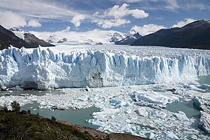
Glaciers occupy the valleys of the main chain and some of the lateral ridges of the Andean Cordillera. In general these glaciers flow into lakes towards the East and into Pacific Ocean fjords towards the West. Some of the larger lakes located to the east of the glaciated Cordillera include; General Carrera Lake, Cochrane/Pueyrredón Lake, O'Higgins/San Martín Lake, Lake Viedma, Argentino Lake and many other smaller lakes. In turn, some of these lakes, as is the case with the first three mentioned, drain into the Pacific Ocean through short mountainous rivers, while others, the later two lakes, flow to the Atlantic Ocean through longer and slower moving rivers. These glacial lakes are often strewn with many icebergs. In Patagonia an immense ice-sheet extended to the east of the present Atlantic coast at the close of the Tertiary epoch, while, during more recent glaciation, the terminal moraines have generally stopped, 30 miles (50 km) in the north and 50 miles (80 km) in the south, east of the summit of the Cordillera. These ice-sheets, which scooped out the greater part of the longitudinal depressions, and appear to have rapidly retreated to the point where the glaciers now exist, did not, however, in their retreat fill up with their detritus the fjords of the Cordillera, for these are now occupied by deep lakes on the east, and on the west by the Pacific channels, some of which are as much as 250 fathoms (460 m) in depth, and soundings taken in them show that the fjords are as usual deeper in the vicinity of the mountains than to the west of the islands. Several of the high peaks are still active volcanoes.
Insofar as its main characteristics are concerned, Patagonia seems to be a portion of the Antarctic continent, the permanence of which dates from very recent times, as is evidenced by the apparent recent emergence of the islets around Chiloé, and by the general character of the pampean formation. Some of the promontories of Chiloé are still called huapi, the Araucanian equivalent for "islands"; and this may perhaps be accepted as perpetuating the recollection of the time when they actually were islands. They are composed of caps of shingle, with great, more or less rounded boulders, sand and volcanic ashes, precisely of the same form as occurs on the Patagonian plateau. From an examination of the pampean formation it is evident that in recent times the land of the province of Buenos Aires extended farther to the east, and that the advance of the sea, and the salt water deposits left by it when it retired, forming some of the lowlands which occur on the littoral and in the interior of the pampas, are much more recent phenomena; and certain caps of shingle, derived from rocks of a different class from those of the neighboring hills, which are observed on the Atlantic coasts of the same province, and increase in quantity and size towards the south, seem to indicate that the caps of shingle which now cover such a great part of the Patagonian territory recently extended farther to the east, over land which has now disappeared beneath the sea, while other marine deposits along the same coasts became converted into bays during the subsequent advance of the sea. There are besides, in the neighbourhood of the present coast, deposits of volcanic ashes, and the ocean throws up on its shores blocks of basaltic lava, which in all probability proceed from eruptions of submerged volcanoes now extinct. One fact, however, which apparently demonstrates with greater certainty the existence in recent times of land that is now lost, is the presence of remains of pampean mammals in Pleistocene deposits in the bay of Puerto San Julian and in Santa Cruz. The animals undoubtedly reached these localities from the east; it is not at all probable that they advanced from the north southwards across the plateau intersected at that time by great rivers and covered by the ice-sheet. With the exception of the discoveries at the inlet of Ultima Esperanza, which is in close communication with the Atlantic valley of Río Gallegos, none of these remains have been discovered in the Andean regions.
[edit] Provinces and regions
[edit] Argentine Patagonia
| Regions of |
|---|
| Argentine Northwest |
| Gran Chaco |
| Mesopotamia |
| Cuyo |
| Pampas |
| Patagonia |
| Antártida Argentina |
[edit] Neuquén


Neuquén covers 94,078 km2 (36,324 sq. miles), including the triangle between the Limay River and Neuquén River, which extends southward to the northern shore of Lake Nahuel-Huapi (41°S) and northward to the Río Colorado.
On the upper plains of Neuquén territory thousands of cattle can be fed, and the forests around Lakes Traful and Nahuel-Huapi yield large quantities of valuable timber. The Neuquén river is not navigable, but as its waters are capable of being easily dammed in places, large stretches of land in its valley are utilized; but the lands on each side of its lower part are of little commercial value.
As the Cordillera is approached the soil becomes more fertile, and suitable districts for the rearing of cattle and other agricultural purposes exist between the regions which surround the Tromen volcano and the first ridges of the Andes. Chos Malal, the capital of the territory, is situated in one of these valleys. More to the west is the mining region, in great part unexplored, but containing deposits of gold, silver, copper and lignite. In the centre of the territory, also in the neighborhood of the mining districts, are the valleys of Norquín and Las Lajas, the general camp of the Argentine army in Patagonia, with excellent timber in the forest on the Andean slope. The wide valleys occur near Río Malleo, Lake Huechulafquén, the river Chimehuin, and Vega de Chapelco, near Lake Lacar, where are situated villages of some importance, such as Junín de los Andes and San Martín de los Andes. Close to these are the famous apple orchards supposed to have been planted by the Jesuits in the 17th and 18th centuries. These regions are drained by the river Collon Cura, the principal affluent of the river Limay. Lake Lacar is now a contributory of the Pacific, its outlet having been changed to the west, owing to a passage having been opened through the Cordillera.
[edit] Río Negro
Río Negro covers 203,013 km2 (78,383 sq. miles), extending from the Atlantic to the Cordillera of the Andes, to the north of 42°S.
The Río Negro River runs along a wide transverse depression, the middle part of which is followed by the railway which runs to the settlement of Neuquén at the confluence of the rivers Limay and Neuquen. In this depression are several settlements, among them Viedma, the capital of the Río Negro territory, Cipolletti, General Conesa, Choele Choel and General Roca. To the south of the Río Negro the Patagonian plateau is intersected by the depressions of the Gualicho and Maquinchao, which in former times directed the waters of two great rivers (now disappeared) to the gulf of San Matias, the first-named depression draining the network of the Collon Cura and the second the Nahuel Huapi lake system. In 42°S there is a third broad transverse depression, apparently the bed of another great river, now perished, which carried to the Atlantic the waters of a portion of the eastern slope of the Andes, between 41° and 42°30;S.
[edit] Chubut


Chubut, covers 224,686 km2 (86,751 sq. miles), embracing the region between 42° and 46°S;
Chubut territory presents the same characteristics as the Río Negro territory. Rawson, the capital, is situated at the mouth of the river Chubut on the Atlantic (42°30'S). The town was founded in 1865 by a group of colonists from Wales, assisted by the Argentine government; and its prosperity has led to the foundation of other important centres in the valley, such as Trelew and Gaiman, which is connected by railway with Puerto Madryn on Bahia Nueva. Here is the seat of the governor of the territory, and by 1895 the inhabitants of this part of the territory, composed principally of Argentines, Welsh and Italians, numbered 552,585. The valley has been irrigated and cultivated, and produces the best wheat of the Argentine Republic. Between the Chubut and the Senguerr there are vast stretches of fertile land, spreading over the Andean region to the foot of the Cordillera and the lateral ridges of the Pre-Cordillera, and filling the basins of some desiccated lakes, which have been occupied since 1885, and farms and colonies founded upon them. The chief of these colonies is that of 16 de Octubre, formed in 1886, mainly by the inhabitants of Chubut colony, in the longitudinal valley which extends to the eastern foot of the Cordillera.
Other rivers in this territory flow into the Pacific through breaches in the Cordillera, e.g. the upper affluents of the Futaleufú River, Palena and Río Cisnes. The principal affluent of the Palena, the Carrenleufu, carries off the waters of Lake General Paz, situated on the eastern slope of the Cordillera. Río Pico, an affluent of the same river, receives nearly the whole of the waters of the extensive undulating plain which lies between the Río Tecka and the Río Senguerr to the east of the Cordillera, while the remainder are carried away by the affluents of Río Jehua: the Cherque, Omkel, and Appeleg. This region contains auriferous drifts, but these, like the auriferous deposits, veins of galena and lignite in the mountains farther west which flank the Cordillera, have not been properly investigated. At Lake Fontana there are auriferous drifts and lignite deposits which abound in fossil plants of the Cretaceous age. The streams which form the rivers Mayo and Chalia join the tributaries of the Río Aisén, which flows into the Pacific, watering in its course extensive and valuable districts where colonization has been initiated by Argentine settlers. Colonies have also been formed in the basin of Lakes Musters and Colhué Huapi; and on the coasts near the Atlantic, along Bahia Camarones and the Gulf of San Jorge, there are extensive farms.
In addition it is one of the highest critically acclaimed group of rivers in the world for fly fishing. Every year thousands of fly fishermen flock there for the hope of catching "the big one".

[edit] Santa Cruz
Santa Cruz is the largest province in the Argentinan Patagonia and the largest political subdivision in the region as a whole, covering 293,993 km2.
The province, mostly a cold, windswept steppe, is well-known for its extensive pebble beaches as well as for the deep-water lakes and vast glaciers in the Andes foothills along its western border with Chile. Santa Cruz's Atlantic coast is also known for the Laguna del Carbón; lying 105 meters (330 ft) below sea level, it is the lowest geographic point in the Western Hemisphere.

One of Santa Cruz's best-known geological curiosities is its Jamarillo Petrified Forests National Monument. Incorporated into the national park system in 1954, the 137 square kilometre (35,000 acre) area includes one of the world's most significant remains of Jurassic-era forests. The National Parks Administration also acquired 600 square kilometres (150,000 acres) of neighboring land, creating the largest natural steppe preserve in Latin America.
Santa Cruz's most notable and most visited geographic feature, however, is probably Perito Moreno Glacier (see section above), a national park as well.
[edit] Chilean Patagonia
[edit] Palena
Palena Province is one of the provinces of the Los Lagos Region, Chile. The capital of the Province is the town of Chaitén.
Within Palena Province you may find several parks and natural reserves such as the Palena Lake National Reserve[6], 122,107 acres (494 km2) of native lenga forrest ,ice caps and high peaks, which can be visited only in summer because of weather conditions, it can be access only by horse or trekking routes.The private Pumalín Park is also located in the province, has 741,316 acres (3,000 km2),it is protected by the State of Chile but owned by Douglas Tompkins, although it is private can be access by the Caleta Gonzalo, where lodging and camping is allowed[7]
In the first quarter of 2008, Chaitén Volcano increase its activity causing damages in the town of Chaitén and spreading volcanic ashes in several touristic points, specifically in Futaleufú[8]
[edit] Aisén

Aisén (also spelled Aysén) is Chile's eleventh administrative region. It is the least populated region in Chile and it remains a region with severe communication problems because of topographical features that make it extremely difficult to quickly improve its infrastructure. The region is known for its unique ecological characteristics including unspoiled habitat for numerous endemic species. Its terrain and form are very similar to those of the Alaska Panhandle, the northern Norwegian coast, and New Zealand's Milford Sound region. Laguna San Rafael National Park, reachable only by boat or plane, is one of its most popular tourist destinations. Until the construction of Route 7, the Southern Highway, in the 1980s, the only overland routes from north to south through the region were extremely primitive tracks.
The Spanish electric company Endesa has recently proposed building a series of hydro-electric dams in Aisén in a project named HidroAysén. HidroAysén project is based on water rights the company acquired before privatization during the military rule of Augusto Pinochet. The dams would first be built on the Baker and Pascua Rivers, but additional dams have been proposed on a number of other previously intact rivers in the area, including the Futaleufú. The power would be transported 1,200 miles (1,900 km) north, via a high-tension transmission line through a number of national parks and protected areas to supply power to the Santiago area where much of the power is used for heavy industry and mining. The project involves the installation of over 5000 High voltage towers,each of them covering a width of 70 metres and a height of 50 metres and the deforestation of the native forest within the trail, the company chosen for the installation is Transelec which was responsible of a project of similar characteristics in Canada[9].
A number of local, national and international environmental organizations oppose the dams, claiming they would destroy the natural heritage of the area and would lead to greatly increased electrical costs for Chilean consumers.
[edit] Magallanes

Magallanes and Chilean Antártica Region is the southernmost, largest and second least populated region of Chile.
This region has many globally known places and geographical accidents like Torres del Paine, Cape Horn, Tierra del Fuego Island, and the Strait of Magellan. It also includes the Antarctic territory claimed by Chile.
The low population and vastness makes this region a good place for many native animal and plant species. It is relatively easy to find penguins, ñandúes, guanacos, condors, and other animals in their natural environment.
The main economic activities are sheep farming, oil extraction and tourism. This region is also home to the one of the world's spectacular adventure races, the Patagonia Expedition Race.

[edit] Tierra del Fuego
Tierra del Fuego is an archipelago at the southernmost tip of Patagonia, divided between Argentina and Chile. It consists of the 47,992 km2 of the Isla Grande de Tierra del Fuego, and several minor islands.

[edit] Climate
The climate is less severe than was supposed by early travelers. The east slope is warmer than the west, especially in summer, as a branch of the southern equatorial current reaches its shores, whereas the west coast is washed by a cold current. At Puerto Montt, on the inlet behind Chiloé Island. The mean annual temperature is 11 °C (52 °F) and the average extremes 25.5 °C (78 °F) and −1.5 °C (29.5 °F), whereas at Bahia Blanca near the Atlantic coast and just outside the northern confines of Patagonia the annual temperature is 15 °C (59 °F) and the range much greater. At Punta Arenas, in the extreme south, the mean temperature is 6 °C (43 °F) and the average extremes 24.5 °C (76 °F) and −2 °C (28 °F). The prevailing winds are westerly, and the westward slope has a much heavier precipitation than the eastern in a rainshadow effect;[3] the western islands close to Torres del Paine receive an annual precipitation of 4,000 to 7,000 mm, whilst the eastern hills are less than 800 mm and the plains may be as low as 200 mm annual precipitation.[3]
The depletion of the ozone layer over the South Pole has been reported as being responsible for blindness and skin cancer in sheep in Tierra del Fuego, and concerns for human health and ecosystems.[10]
[edit] Vegetation
Due to the wide variation in temperature, precipitation and altitude, there are clear vegetation patterns. Moorland with bogs and dwarf shrubs, termed Magellanic moorland, predominates along the south western coast where there are high winds and precipitation. Around the ice-fields, high rainfall in sheltered areas allows mixed evergreen temperate rain forest (Magellanic subpolar forests) of southern beech (Nothofagus betuloides). Mixed deciduous woodland (Valdivian temperate rain forests) is found in areas of lower precipitation, including Nothofagus pumilio, Berberis and Gunnera magellanica.[3]
On the eastern side of the mountains, there are also areas of rain forest and bog where precipitation is high. Beyond this zone on the wide steppe there is grassland with low shrubs, with tough Festuca tussock-grasses resistant to low precipitation and high winds.[3] In spring and summer, the grassland is interspersed with low plants covered in small blossoms.[11]
The calafate (Berberis buxifolia) is considered the symbol of Patagonia. An evergreen shrub, its berries are edible and used to make a popular jam. A legend tells that eating the berry makes people certain to return to Patagonia.[11] The large and long-living alerce is an iconic tree of the Lake District, protected in Los Alerces National Park.[11]
[edit] Fauna

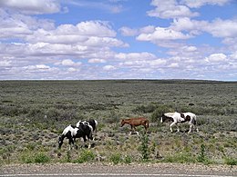
The guanaco, the cougar, the zorro or Brazilian fox (Canis azarae), the zorrino or Mephitis patagonica (a kind of skunk), and the tuco-tuco or Ctenomys magellanicus (a subterranean rodent) are the most characteristic mammals of the Patagonian plains. The guanaco roam in herds over the country and form with the rhea (Rhea americana, and more rarely Rhea darwinii) formerly the chief means of subsistence for the natives, who hunted them on horseback with dogs and bolas. Vizcacha (Lagidum spp.) and Mara (Dolichotis) are also characteristic of the steppe and the Pampas to the north.
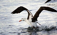
Bird-life is often wonderfully abundant. The carancho or carrion-hawk (Polyborus tharus) is one of the characteristic objects of a Patagonian landscape; the presence of long-tailed green parakeets (Conurus cyanolysius) as far south as the shores of the strait attracted the attention of the earlier navigators; and hummingbirds may be seen flying amidst the falling snow. Of the many kinds of water-fowl it is enough to mention the flamingo, the upland goose, and in the strait the remarkable steamer duck.
Signature marine fauna include the Southern right whale, the Magellanic penguin, the Orca and elephant seals. The Valdés Peninsula is a UNESCO World Heritage Site for its importance as a nature reserve.
[edit] History
- See also: History of Argentina, History of Chile and Argentina-Chile relations
[edit] Pre-Columbine Patagonia (10,000 BC-1520 AD)
Human habitation of the region dates back thousands of years, with some early archaeological findings in the area dated to at least the 13th millennium BCE, although later dates of around the 10th millennium BCE are more securely recognised. There is evidence of human activity at Monte Verde in Llanquihue Province, Chile dated to around 12,500 BCE.[3] The glacial period ice-fields and subsequent large meltwater streams would have made settlement difficult at that time.
The region seems to have been inhabited continuously since 10,000 BCE, by various cultures and alternating waves of migration, the details of which are as yet poorly understood. Several sites have been excavated, notably caves such as Cueva del Milodon[12] in Última Esperanza in southern Patagonia, and Tres Arroyos on Tierra del Fuego, that support this date.[3] Hearths, stone scrapers, animal remains dated to 9,400-9,200 BCE have been found east of the Andes.[3]
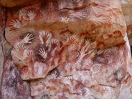
The Cueva de las Manos is a famous site in Santa Cruz, Argentina. A cave at the foot of a cliff, it has wall paintings, particularly the negative images of hundreds of hands, believed to date from around 8,000 BCE.[3]
Hunting of guanaco was the most important activity, and rhea (ñandu) to a lesser extent, it appears from artifacts.[3] It is unclear whether the megafauna of Patagonia, including the ground sloth and horse, were extinct in the area before the arrival of humans, although this is now the more widely accepted account. It is also not clear if domestic dogs were part of early human activity. Bolas are commonly found and were used to catch guanaco and rhea.[3] A maritime tradition appeared amongst the Yámana to the south of the Beagle Channel.
The indigenous peoples of the region included the Tehuelches, whose numbers and society were reduced to near extinction not long after the first contacts with Europeans. Tehuelches included the Gununa'kena to the north, Mecharnuekenk in south central Patagonia and the Aonikenk or Southern Tehuelche in the far South, north of the Magellan channel. On Isla Grande de Tierra del Fuego, the Selk'nam (Ona) and Haush (Mannekenk) lived in the north and south east respectively. In the archipelagos to the south of Tierra del Fuego were Yámana, with the Kawéskar (Alakaluf) in the coastal areas and islands in western Tierra del Fuego and the south west of the mainland.[3] These groups were encountered in the first periods of European contact with different lifestyles, body decoration and language, although it is unclear when this configuration emerged.
Around 1,000 BCE, Mapuche-speaking agriculturalists penetrated the western Andes and from there across into the eastern plains and down to the far south. Through confrontation and technological ability, they came to dominate the other peoples of the region in a short space of time, and are the principal indigenous community today.[3] The Tehuelche model of domination through technological superiority and armed confrontation was later repeated as Europeans implemented a succeeding but conceptually identical cycle, essentially replacing the position of the former dominators with a new, albeit predominately European class.
[edit] Early European exploration and Spanish conquest attempts (1520-1584)
The region of Patagonia was to be first noted in European accounts in 1520 by the expedition of Ferdinand Magellan, who on his passage along the coast named many of the more striking features – Gulf of San Matias, Cape of 11,000 Virgins (now simply Cape Virgenes), and others. However, it is also possible that earlier navigators such as Amerigo Vespucci had reached the area (his own account of 1502 has it that he reached its latitudes), however his failure to accurately describe the main geographical features of the region such as the Río de la Plata casts some doubt on whether he really did so.
Rodrigo de Isla, sent inland in 1535 from San Matias by Simón de Alcazaba Sotomayor (on whom western Patagonia had been conferred by Carlos V of Spain), is presumed to have been the first European to traverse the great Patagonian plain. If the men under his charge had not mutinied, he might have been able to cross the Andes to reach the Chilean side.
Pedro de Mendoza, on whom the country was next bestowed, lived to found Buenos Aires, but not to carry his explorations to the south. Alonzo de Camargo (1539), Juan Ladrilleros (1557) and Hurtado de Mendoza (1558) helped to make known the western coasts, and Sir Francis Drake's voyage in 1577 down the eastern coast through the strait and northward by Chile and Peru was memorable for several reasons; but the geography of Patagonia owes more to Pedro Sarmiento de Gamboa (1579–1580), who, devoting himself especially to the south-west region, made careful and accurate surveys. The settlement which he founded at Nombre de Dios and San Felipe were neglected by the Spanish government, the latter being abandoned before Thomas Cavendish visited it in 1587 and was so desolate that he called it Port Famine.
The district in the neighbourhood of Puerto Deseado, explored by John Davis about the same period, was taken possession of by Sir John Narborough in the name of King Charles II of England in 1669.
[edit] Patagonian giants: early European perceptions
According to Antonio Pigafetta,[1] one of the Magellan expedition's few survivors and its published chronicler, Magellan bestowed the name "Patagão" (or Patagón) on the inhabitants they encountered there, and the name "Patagonia" for the region. Although Pigafetta's account does not describe how this name came about, subsequent popular interpretations gave credence to a derivation meaning 'land of the big feet'. However, this etymology is questionable. The term is most likely derived from an actual character name, "Patagón", a savage creature confronted by Primaleón of Greece, the hero in the homonymous Spanish chivalry novel (or knight-errantry tale) by Francisco Vázquez.[13] This book, published in 1512, was the sequel of the romance "Palmerín de Oliva," much in fashion at the time, and a favourite reading of Magellan.[14] Magellan's perception of the natives, dressed in skins, and eating raw meat, clearly recalled the uncivilized Patagón in Vázquez's book.

The main interest in the region sparked by Pigafetta's account came from his reports of their meeting with the local inhabitants, who they claimed to measure some nine to twelve feet in height —"...so tall that we reached only to his waist"—, and hence the later idea that Patagonia meant "big feet". This supposed race of Patagonian giants or Patagones entered into the common European perception of this little-known and distant area, to be further fuelled by subsequent reports of other expeditions and famous-name travellers like Sir Francis Drake, which seemed to confirm these accounts. Early charts of the New World sometimes added the legend regio gigantum ("region of the giants") to the Patagonian area. By 1611 the Patagonian god Setebos (Settaboth in Pigafetta) was familiar to the hearers of The Tempest.
The concept and general belief persisted for a further 250 years, and was to be sensationally re-ignited in 1767 when an "official" (but anonymous) account was published of Commodore John Byron's recent voyage of global circumnavigation in HMS Dolphin. Byron and crew had spent some time along the coast, and the publication (Voyage Round the World in His Majesty's Ship the Dolphin) seemed to give proof positive of their existence; the publication became an overnight best-seller, thousands of extra copies were to be sold to a willing public, and other prior accounts of the region were hastily re-published (even those in which giant-like folk were not mentioned at all).
However, the Patagonian giant frenzy was to die down substantially only a few years later, when some more sober and analytical accounts were published. In 1773 John Hawkesworth published on behalf of the Admiralty a compendium of noted English southern-hemisphere explorers' journals, including that of James Cook and John Byron. In this publication, drawn from their official logs, it became clear that the people Byron's expedition had encountered were no taller than 6-foot-6-inch (2.0 m), tall perhaps but by no means giants. Interest soon subsided, although awareness of and belief in the myth persisted in some quarters even up into the 20th century.[15]
[edit] Scientific exploration (1764-1842)
In the second half of the 18th century, European knowledge of Patagonia was further augmented by the voyages of the previously-mentioned John Byron (1764–1765), Samuel Wallis (1766, in the same HMS Dolphin which Byron had earlier sailed in) and Louis Antoine de Bougainville (1766). Thomas Falkner, a Jesuit who resided near forty years in those parts, published his Description of Patagonia (Hereford, 1774); Francesco Viedma founded El Carmen, and Antonio advanced inland to the Andes (1782); and Basilio Villarino ascended the Rio Negro (1782).
Two hydrographic surveys of the coasts were of first-rate importance: the first expedition (1826–1830) including HMS Adventure and HMS Beagle under Phillip Parker King, and the second (1832–1836) being the voyage of the Beagle under Robert FitzRoy. The latter expedition is particularly noted for the participation of Charles Darwin who spent considerable time investigating various areas of Patagonia onshore, including long rides with gauchos in Río Negro, and who joined FitzRoy in a 200 miles (320 km) expedition taking ships boats up the course of the Santa Cruz river.
[edit] Chilean and Argentine expansion (1843-1902)

Following the last instructions of Bernardo O'Higgins, the Chilean president Manuel Bulnes sent an expedition to the Strait of Magellan and founded Fuerte Bulnes in 1843. Five years later, the Chilean government moved the main settlement to the current location of Punta Arenas, the oldest permanent settlement in Southern Patagonia. The creation of Punta Arenas was instrumental in making Chile's claim of the Strait of Magellan permanent.
In the mid-19th century the newly-independent nations of Argentina and Chile began an aggressive phase of expansion into the south, increasing confrontation with the indigenous populations. In 1860, a French adventurer Orelie-Antoine de Tounens proclaimed himself king of The Kingdom of Araucania and Patagonia of the Mapuche. Captain George Chaworth Musters in 1869 wandered in company with a band of Tehuelches through the whole length of the country from the strait to the Manzaneros in the north-west, and collected a great deal of information about the people and their mode of life. In the 1870s the Conquest of the Desert was a controversial campaign by the Argentine government, executed mainly by General Julio Argentino Roca, to subdue or, some claim, to exterminate the native peoples of the South. By the mid-1880s the campaign's objectives had largely been achieved.
In 1885 a mining expeditionary party under the Romanian adventurer Julius Popper landed in southern Patagonia in search of gold, which they found after travelling southwards towards the lands of Tierra del Fuego. This further opened up some of the area to prospectors.
European missionaries and settlers arrived through the 19th and 20th centuries, notably the Welsh settlement of the Chubut Valley.
During the first years of the 20th century, the border between the two nations in Patagonia was established by the mediation of the British crown. But it has undergone a lot of modifications since then, and there is still one place (50 km long) where there is no border established (Southern Patagonia Icefield).
Until 1902, most of Patagonia was settled by Chilotes who worked in cattle farming. Before and after 1902, when the boundaries were drawn, a lot of Chilotes were expelled from the Argentine side. These workers founded the first inland Chilean settlement in what is now the Aisén Region;[16][17] Balmaceda. Lacking good grasslands on the forest-covered Chilean side, the immigrants burned down the forest, setting fires that could have lasted more than two years.[17]
[edit] Economy
As described above by province, the area's principal economic activities have been mining, whaling, livestock (notably sheep throughout) agriculture (wheat and fruit production near the Andes towards the north), and oil after its discovery near Comodoro Rivadavia in 1907.[11] Energy production is also a crucial part of the local economy. Railways were planned to cover continental Argentine Patagonia to serve the oil, mining, agricultural and energy industries, and a line was built connecting San Carlos de Bariloche to Buenos Aires. Portions of other lines were built to the south, but the only lines still in use are La Trochita in Esquel, the 'Train of the End of the World' in Ushuaia, both heritage lines,[18] and a short run Tren Histórico de Bariloche to Perito Moreno.

Sheep farming introduced in the late 19th century has been a principal economic activity. After reaching its heights during the First World War, the decline in world wool prices affected sheep farming in Argentina. Nowadays about half of Argentina's 15 million sheep are in Patagonia, a percentage that is growing as sheep farming disappears in the Pampa (to the North). Chubut (mainly Merino) is the top wool producer with Santa Cruz (Corriedale and some Merino) second. Sheep farming revived in 2002 with the devaluation of the peso and firmer global demand for wool (lead by China and the EU). Still there is little investment in new abbatoirs (mainly in Comodoro Rivadavia, Trelew and Rio Gallegos), and often there are phitosanitary restrictions to the export of sheep meat. Extensive valleys in the Cordilleran range have provided sufficient grazing lands, and the low humidity and weather of the southern region make raising Merino and Corriedale sheep common.
Livestock also includes small numbers of cattle, and in lesser numbers pigs and horses. Sheep farming provides small but important jobs located in rural areas where there is little else.
In the second half of the 20th century, tourism became an ever more important part of Patagonia's economy. Originally a remote backpacking destination, the region has attracted increasing numbers of upmarket visitors, cruise passengers rounding Cape Horn or visiting Antarctica, and adventure and activity holiday-makers. Principal tourist attractions include the Perito Moreno glacier, the Valdés Peninsula, Torres del Paine national park, the Argentine Lake District and Ushuaia and Tierra del Fuego. Tourism has created new markets locally and for export for traditional crafts such as Mapuche handicrafts, guanaco textiles, and confectionery and preserves.[11]
At the urging of the Chilean government, the Spanish company Endesa hopes to build a number of large hydro-electric dams in the Chilean Patagonia, which has raised environmental concerns from a large number of local and international NGOs. The first dams proposed would be built on the Baker and Pascua rivers, but dams have also been proposed on others, including the famed Futalefu in Chile and Santa Cruz river in Argentina. The dams will affect the minimium ecological flows and threaten the fishing, wilderness-tourism and agricultural interests along the river. The electricity would be fed into high-tension lines (to be built by a Canadian company) and taken 1,200 miles (1,900 km) north to the industry and mining hub around Santiago. The lines would cut through a number of previously pristine national parks and protected areas. The Chilean government considers the power to be essential for economic growth, while opponents claim it will destroy Patagonia's growing tourism industry. No evidence has been produced from the experience in other nations that the presence of electrical transmission lines has significantly affected tourism. In fact, opponents of the program have utilized billboard advertising in Chile which superimposes images of power lines over scenes of Torres del Paine national park, where no proposals for such lines have been made.

A spin-off from increased tourism has been the buying of often enormous tracts of land by foreigners, often as a prestige purchase rather than for agriculture. Buyers have included Sylvester Stallone, Ted Turner and Christopher Lambert, and most notably Luciano Benetton, Patagonia's largest landowner.[11] His Compañia de Tierras Sud has brought new techniques to the ailing sheep-rearing industry and sponsored museums and community facilities, but has been controversial particularly for its treatment of local Mapuche communities.[19]
Argentine Patagonian cuisine is largely the same as the cuisine of Buenos Aires - grilled meats and pasta - with extensive use of local ingredients and less use of those products which have to be imported into the region. Lamb is considered the traditional Patagonian meat, grilled for several hours over an open fire. Some guide books have reported that game, especially guanaco and introduced deer and boar, are popular in restaurant cuisine. However, since the guanaco is a protected animal in both Chile and Argentina, it is unlikely to appear commonly as restaurant fare. Trout and centolla (king crab) are also common, though over-fishing of centolla has made it increasingly scarce. In the area around Bariloche, there is a noted Alpine cuisine tradition, with chocolate bars and even fondue restaurants, and tea rooms are a feature of the Welsh communities in Gaiman and Trevelin as well as in the mountains.[11]
[edit] Foreign land buyers issue
Foreign investors, including Italian multimillionational Benetton Group and the environmentalist Douglas Tompkins, own major land areas. This situation have caused several conflicts with local inhabitants and the governments of Chile and Argentina for example the opposition by Douglas Tompkins to the planned route for Carretera Austral in Pumalín Park. Benetton has faced criticism from Mapuche organizations, including Mapuche International Link, over its purchase of traditional Mapuche lands in Patagonia.[20] The Curiñanco-Nahuelquir family was evicted from their land in 2002 following Benetton's claim to it, but the land was restored in 2007.[21] During discussions with indigenous rights groups it was pointed out that the Mapuche had only acquired the disputed land through violence and armed confrontation that resulted in displacement of earlier tribes, and that a more modern model of displacement was hardly any more or less defensible than the means by which the historical Mapuche had acquired the lands during antiquity.
[edit] Further reading
- Patagonia: A Cultural History, 2008, ISBN 9781904955382
- Patagonia : a forgotten land: from Magellan to Perón, 2007, ISBN 9781845640613
- The wild shores of Patagonia: the Valdés Peninsula and Punta Tombo, 2000, ISBN 0810943522
- Birds of Patagonia, Tierra del Fuego & Antarctic Peninsula: the Falkland Islands & South Georgia = Aves de Patagonia, Tierra del Fuego y Península Antártica : Islas Malvinas y Georgia del Sur, 2003, ISBN 9568007040
- The South American table: the flavor and soul of authentic home cooking from Patagonia to Rio de Janeiro, with 450 recipes, 2003, ISBN 1558322485
- Chatwin, Bruce "In Patagonia" (1977)
- Theroux, Paul "The Old Patagonian Express" (1979)
- The Last Cowboys at the End of the World: The Story of the Guachos of Patagonia,2002, ISBN 0609810049
- Moss, Chris "Patagonia: A Cultural History" (2008) ISBN 978-1904955382
[edit] See also
- Kingdom of Araucania and Patagonia
- Araucanization
- Cerro Hudson
- Conquest of the Desert
- List of deserts by area
- Patagonian Ice Sheet
- Southern Cone
- Domuyo Volcano
- Torres del Paine National Park
- Patagonian Expedition Race
[edit] References
- ^ a b Antonio Pigafetta, Relazione del primo viaggio intorno al mondo, 1524: "Il capitano generale nominò questi popoli Patagoni." The original word would probably be in Magellan's native Portuguese (patagão) or the Spanish of his men (patagón). It has been interpreted later as "big foot" but the etymology refers to a literary character in a Spanish novel of the early XVI century (see text).
- ^ Fondebrider, Jorge (2003). "chapter 1 (Ámbitos y voces)" (in Spanish). Versiones de la Patagonia (1st edition ed.). Buenos Aires, Argentina: Emecé Editores S.A.. pp. 29. ISBN 950-04-2498-3.
- ^ a b c d e f g h i j k l m n o p Patagonia: Natural History, Prehistory and Ethnography at the Uttermost End of the Earth, C. McEwan, L.A. Borrero and A. Prieto (eds), Princeton University Press with British Museum Press, 1997. ISBN 0-691-05849-0
- ^ Argentina: Population Census of 2001.
- ^ Chile: Population Census of 2002.
- ^ Palena lake national reserve article in Letsgochile.com
- ^ Pumalin Private park articlein Letsgochile.com
- ^ Turismo retoma actividades en Palena tras erupción de volcán article La Tercera Newspaper
- ^ Patagonia Chilena without dams de Patagoniasinrepresas.cl]
- ^ Southern Chile warned of high radiation levels under ozone hole, CNN.com, October 10, 2000, accessed 2006-08-11
- ^ a b c d e f g Time Out Patagonia, Cathy Runciman (ed), Penguin Books, 2002. ISBN 0-14-101240-4
- ^ C. Michael Hogan (2008) Cueva del Milodon, The Megalithic Portal, ed. A. Burnham [1]
- ^ The Cambridge Encyclopedia of Human Growth and Development, By Stanley J. Ulijaszek, Francis E. Johnston, M. A. Preece. Cambridge University Press, 1998, p. 380: "Patagonian Giants: Myths and Possibilities."
- ^ Carolyne Ryan, "European Travel Writings and the Patagonian giants: How Patagonia got its name - among other things." Lawrence University Today magazine, Fall 2004.
- ^ Carolyne Ryan. "European Travel Writings and the Patagonian giants". Lawrence University. http://www.lawrence.edu/news/pubs/lt/fall04/giants.shtml. Retrieved on August 15 2005.
- ^ Coihaique - Ciudades y Pueblos del sur de Chile
- ^ a b Luis Otero, La Huella del Fuego: Historia de los bosques y cambios en el paisaje del sur de Chile (Valdivia, Editorial Pehuen)
- ^ History of the Old Patagonian Express, La Trochita, accessed 2006-08-11
- ^ 'The Invisible Colours of Benetton', Mapuche International Link, accessed 2006-08-11
- ^ "The Invisible Colours of Benetton - Campaign". http://www.mapuche-nation.org/english/main/benetton/main/info.htm. Retrieved on 2008-04-07.
- ^ "Recovered Mapuche territory in Patagonia: Benetton vs. Mapuche". MAPU Association. http://www.santarosarecuperada.com.ar/english/index.html. Retrieved on 2008-04-07.
This article incorporates text from the Encyclopædia Britannica, Eleventh Edition, a publication now in the public domain.
[edit] External links
| Wikimedia Commons has media related to: Patagonia |
- Patagonia in Swedish
- Patagonia Webcam from Paine and Puerto Natales
- Virtual Classroom:Patagonia
- The Living Edens: Patagonia from PBS
- Patagonia from National Geographic
- Mountaineer history of Patagonia
- Aborigines of Patagonia
- Santa Cruz Sub Secretary Of Tourism
- Patagonia SinRepresas (Spanish)
- torresdelpaine.com (Spanish)
- Santa Cruz Patagonia (Spanish)
- Noticias Turisticas de Santa Cruz Patagonia (Spanish)
- Patagonian Expedition Race
|
|||||||||||||||||||||||||||||||||

