Pitcairn Islands
From Wikipedia, the free encyclopedia
| Pitcairn Islands
Pitkern Ailen
|
||||||
|---|---|---|---|---|---|---|
|
||||||
| Anthem: "Come ye Blessed" "God Save the Queen" |
||||||
 |
||||||
| Capital (and largest city) |
Adamstown | |||||
| Official languages | English, Pitkern[citation needed] | |||||
| Ethnic groups | Pitcairners, English | |||||
| Government | British Overseas Territory | |||||
| - | Sovereign | Elizabeth II | ||||
| - | Governor | George Fergusson | ||||
| - | Mayor | Mike Warren | ||||
| Area | ||||||
| - | Total | 47 km2 18.1 sq mi |
||||
| Population | ||||||
| - | 1 July 2007 estimate | 48 (221st) | ||||
| - | Density | 1/km2 (197th) 2.7/sq mi |
||||
| Currency | New Zealand dollar (NZD) |
|||||
| Time zone | (UTC-8) | |||||
| Internet TLD | .pn | |||||
| Calling code | 64 | |||||


The Pitcairn Islands (pronounced /ˈpɪtkærn/;[1] Pitkern: Pitkern Ailen), officially named the Pitcairn, Henderson, Ducie and Oeno Islands, are a group of four volcanic islands in the southern Pacific Ocean. The islands are a British overseas territory (formerly a British colony), the last remaining in the Pacific. Only Pitcairn Island — the second largest — is inhabited.
The islands are best known for being the home of the descendants of the Bounty mutineers and the Tahitians who accompanied them, an event retold in numerous books and films. This story is still apparent in the surnames of many of the islanders. With only 48 inhabitants (from nine families), Pitcairn is also notable for being the least populated jurisdiction in the world (although it is not a sovereign nation). The United Nations Committee on Decolonisation includes the Pitcairn Islands on the United Nations list of Non-Self-Governing Territories.[2]
Contents |
[edit] History

The original settlers of the Pitcairn Islands (Ducie, Henderson, Oeno, and Pitcairn) were Polynesians who appear to have lived on Pitcairn and Henderson for several centuries. Although archaeologists believe that Polynesians were living on Pitcairn as late as the 15th century, the islands were uninhabited when they were discovered by Europeans.[3]
Ducie and Henderson Islands are believed to have been discovered by Europeans on 26 January 1606 by Portuguese sailor Pedro Fernandes de Queirós, sailing for the Spanish crown, who named them La Encarnación ("Incarnation") and San Juan Bautista ("Saint John the Baptist"), respectively. However, some sources express doubt about exactly which of the islands were visited and named by Queirós, suggesting that Queirós’ La Encarnación may actually have been Henderson Island, and San Juan Bautista may have been Pitcairn Island.[4]
Ducie Island was rediscovered in 1791 by the British Capt. Edwards aboard HMS Pandora and named after Francis, Lord Ducie, a captain in the Royal Navy. It was annexed by Britain on 19 December 1902, and in 1938 it was formally incorporated into Pitcairn to become part of a single administrative unit (the "Pitcairn Group of Islands").
Henderson Island was rediscovered on 17 January 1819 by a British Captain James Henderson of the British East India Company ship Hercules. On 2 March 1819, Captain Henry King, sailing aboard the Elizabeth, landed on the island to find the king's colours already flying. His crew scratched the name of their ship into a tree, and for some years the island's name was Elizabeth or Henderson, interchangeably. Henderson Island was annexed by Britain and incorporated into Pitcairn in 1938.
Oeno Island was discovered on 26 January 1824 by U.S. Captain George Worth aboard the whaler Oeno. On 10 July 1902, Oeno was annexed by Britain. It was incorporated into Pitcairn in 1938.
Pitcairn Island itself was discovered on 3 July 1767 by the crew of the British sloop HMS Swallow, commanded by Captain Philip Carteret (though according to some it had perhaps been visited by Queirós in 1606). It was named after Midshipman Robert Pitcairn, a fifteen-year-old crewmember who was the first to sight the island. Robert Pitcairn was the son of British Marine Officer John Pitcairn.

Carteret, who sailed without the newly invented accurate marine chronometer, charted the island at 25° 2' south 133° 21’ west of Greenwich and although the latitude was reasonably accurate the longitude was incorrect by about 3° (during the age of sail about two day voyage under fair conditions). This made Pitcairn difficult to find, as highlighted by the failure of Captain James Cook to locate the island in July 1773.[5][6]
In 1790, the mutineers of the Bounty and their Tahitian companions, some of whom may have been kidnapped from Tahiti, settled on Pitcairn Island and set fire to the Bounty. The wreck is still visible underwater in Bounty Bay. The ship itself was discovered in 1957 by National Geographic explorer Luis Marden. Although the settlers were able to survive by farming and fishing, the initial period of settlement was marked by serious tensions among the settlers. Alcoholism, murder, disease and other ills took the lives of most mutineers and Tahitian men. John Adams and Ned Young turned to the Scriptures using the ship's Bible as their guide for a new and peaceful society. Young eventually died of an asthmatic infection. The Pitcairners also converted to Christianity; later they would convert from their existing form of Christianity to Adventism after a successful Adventist mission in the 1890s. After the rediscovery of Pitcairn John Adams was granted amnesty for his mutiny.
The islanders reported that it was not until 27 December 1795 that the first ship since the Bounty was seen from the island, but as she did not approach the land, they could not make out to what nation she belonged. A second appeared some time in 1801, but did not attempt to communicate with them. A third came sufficiently near to see their habitations, but did not venture to send a boat on shore. The American trading ship Topaz under the command of Mayhew Folger was the first to visit the island and communicate with them when they spent 10 hours at Pitcairn in February 1808. A report of Folger's find was forwarded to The Admiralty mentioning the mutineers and a more precise location of the island—latitude 25° 2' S and 130° longitude/,[7]—however this rediscovery was not known to Sir Thomas Staines who commanded a Royal Navy flotilla of two ships (HMS Briton and HMS Tagus) which found the island at 25°.4' S. (by meridian observation) on 17 September 1814. Staines sent a party ashore and wrote a detailed report for the Admiralty.[8][9][10]

The island became a British colony in 1838 and was among the first territories to extend voting rights to women. By the mid-1850s the Pitcairn community was outgrowing the island and its leaders appealed to the British government for assistance. They were offered Norfolk Island and on 3 May 1856, the entire community of 193 people set sail for Norfolk on board the Morayshire, arriving on 8 June after a miserable five-week trip. But after eighteen months on Norfolk, seventeen of the Pitcairners returned to their home island; five years later another twenty-seven did the same.
Since a population peak of 233 in 1937, the island has been suffering from emigration, primarily to New Zealand, leaving some fifty people living on Pitcairn.
There are allegations of a long history and tradition of sexual abuse of girls as young as 7, which culminated in 2004 in the charging of seven men living on Pitcairn, and another six now living abroad, with sex-related offences, including rape. On 25 October 2004, six men were convicted, including Steve Christian, the island's mayor at the time. See Pitcairn rape trial of 2004. After the six men lost their final appeal, the British government set up a prison on the island with an annual budget of NZD 950,000. The men began serving their sentences in late 2006, and all are expected to be freed by December 2008.
[edit] Politics
[edit] Military
The Pitcairn Islands are an overseas territory of the United Kingdom, meaning defence is the responsibility of the Ministry of Defence and Her Majesty's Armed Forces.
[edit] Geography


The Pitcairn Islands form the southeasternmost extension of the geological archipelago of the Tuamotus of French Polynesia and consist of five islands: Pitcairn Island, Sandy Island (the last one found), Oeno Island (atoll with five islets), Henderson Island and Ducie Island (atoll with four islets).
The only permanently inhabited island, Pitcairn, is accessible only by boat through Bounty Bay.
Henderson Island, covering about 86% of the territory's total land area and supporting a rich variety of animals in its nearly inaccessible interior, is also capable of supporting a small human population, but access is difficult, its outer shores comprising steep limestone cliffs of sharp coral.
The Pitcairn Islands were formed by a center of upwelling magma called the Pitcairn hotspot.
The other islands are at a distance of more than 100 km (60 miles) and are not habitable.
The Pitcairn Islands are one of two places in the world in which the plant species Glochidion pitcairnense occurs.

| Island or atoll | Type | Land area (km²) |
Total area (km²) |
Pop. July 2007 |
Coordinates |
|---|---|---|---|---|---|
| Ducie Island | Atoll | 0.7 | 3.9 | - | |
| Henderson Island | uplifted coral island | 37.3 | 37.3 | - | |
| Oeno Island | Atoll | 0.65 | 16.65 | - | |
| Pitcairn Island | volcanic island | 4.6 | 4.6 | 67 | |
| Pitcairn Islands | island group | 43.25 | 62.45 | 67 | 23°55'26" to 25°04'00"S, 124°47'11" to 130°44'03"W |
^ Includes reef flat and lagoon of the atolls
[edit] Economy

The fertile soil of the Pitcairn valleys produces a wide variety of fruits and vegetables, including citrus, sugarcane, watermelons, bananas, yams, and beans. The inhabitants of this tiny economy exist on fishing, subsistence farming, and handicrafts, with barter being an important part of the economy. The major sources of revenue are the sale of postage stamps to collectors, honey, and the sale of handicrafts to passing ships, most of which are plying the United Kingdom to New Zealand route via the Panama Canal. Trade is restricted by the jagged geography of the island, which lacks a harbour or airstrip, forcing all trade to be made by longboat to visiting ships. Occasionally, passengers from expedition-type cruise ships will come ashore for a day, weather permitting.[citation needed]
The island has a labour force of 15 men and women (as of 2004).[citation needed]
Electricity on the island is provided by gas/diesel generators.
[edit] Demographics

The majority of the resident Pitcairn Islanders are the descendants of the Bounty mutineers and Tahitians. Pitkern is a creole language derived from eighteenth century English, with elements of the Tahitian language. It is spoken as a first language by the population and is taught alongside standard English at the island's only school. It is closely related to the creole language Norfuk spoken on Norfolk Island, because Norfolk was repopulated in the mid-nineteenth century by Pitcairners.
In September 2003, the first baby was born on the islands in 17 years. Another child, Adrianna Tracey Christian, was born on Pitcairn on 3 March 2007.
In February 2005, Shirley and Simon Young became the first married outsider couple in recorded history to obtain citizenship on Pitcairn.
100% of the Pitcairn Islanders are Seventh-Day Adventist Christians. [11]
[edit] Culture and society

Pitcairn culture, like its language, is a mix of English and Tahitian influences. A successful Seventh-day Adventist mission in the 1890s was important in shaping Pitcairn society, though the inhabitants were already observing the Seventh-day Sabbath before the arrival of Adventism.[12] In recent years, the church has declined, with only about eight islanders worshipping regularly, but most of them still attend church on special occasions. The Sabbath is observed as a day of rest and as a mark of respect for observant Adventists.
The once-strict moral codes, which prohibited dancing, public displays of affection, and consumption of alcohol, have been relaxed in recent years. Islanders may now obtain a six-month license to purchase alcohol; the licence fee is NZ$10.00 for residents and NZ$25.00 for tourists.
Education is free and compulsory between the ages of five and 15.[13] All of the island’s seven children were enrolled in school in 2000.[13]
[edit] Communications
- Telephones: There are only satellite phones on the island, replacing a single wired party line. A single pay phone also exists. [14] Islanders call between homes and ships via VHF radio.
- Radio: There is no broadcast station. Marine band walkie-talkie radios are used to maintain contact among people in different areas of the island. Foreign stations can be picked up on Shortwave Radio.
- Television: There is no broadcast TV; most houses have a VCR/DVD-player to watch videos. Free-To-Air satellite dishes can be used to watch foreign TV.
- Internet: There is one Government-sponsored satellite internet connection, networked to all houses on the island. Pitcairn's country code (top level domain) is .pn.
[edit] Transport
The settlers of the Pitcairns all arrived by some form of boat or ship; the most famous was the Bounty, on which the mutiny occurred and which was burned in Bounty Bay.
Pitcairn Island does not have an airport or seaport; the islanders rely on longboats to ferry people and goods between ship and shore through Bounty Bay. The island does have one small harbor and launch ramp that is used to dock and load long-boats, but it is so small and the water so shallow that only small-craft can fit. To get to Pitcairn it is necessary to fly to Tahiti, then Mangareva, then embark on a further 30-hour boat ride. There is one boat every several months. Alternatively, passage can be obtained aboard a few freighters out of New Zealand; it is a seven-day trip via freighter. Leaving the island is hit-and-miss; one leaves when transportation happens by, not necessarily when one wishes to go.
There is one 6.4-kilometre (4 mi) paved road and there are no railways. On land, walking has historically been the way of getting around.
In the early 1970s it was decided to bring the first vehicle to the island (a Mini Moke) to make it easier to transport the elderly, but the harsh terrain and heavy rain were too much for the diminutive car and a second and eventually a third had to be sent out to replace it. More suitable all-terrain vehicles have become common in more recent years.[15]
[edit] Gallery
 Pitcairn Landing site |
 Pitcairn Island |
 Henederson Island shelter |
 Oeno |
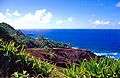 St. Pauls Point in west Pitcairn Island |
 Garnets Ridge, Pitcairn Island |
[edit] See also
- Law enforcement in the Pitcairn Islands
- Pitcairn sexual assault trial of 2004
- Postage stamps and postal history of Pitcairn Islands
[edit] References
- ^ Merriam-Webster's Geographical Dictionary (1998)
- ^ United Nations list of Non-Self-Governing Territories
- ^ Diamond, Jared M (2005). Collapse: how societies choose to fail or succeed. New York: Penguin. pp. 132. ISBN 9780143036555. OCLC 62868295. "But by A.D. 1606 … Henderson’s population had ceased to exist. Pitcairn’s own population had disappeared at least by 1790 … and probably disappeared much earlier."
- ^ Pitcairn Islands, "History of Government and Laws, Part 15" 30 September 2006
- ^ Hooker, Brian. "Down with Bligh - hurrah for Tahiti". Finding New Zealand. http://www.findingnz.co.nz/al/gal1_bounty.htm.
- ^ Winthrop, Mark. "The Story of the Bounty Chronometer". Lareau Web Parlour. http://www.lareau.org/chrono.html. Retrieved on 2008-09-17.
- ^ "Mutineers of the Bounty". The European Magazine, and London Review (Philological Society of London,) 69: 134. January-June 1816. http://books.google.co.uk/books?id=mOwRAAAAYAAJ&pg=PA62#PPA134,M1.
- ^ Staff. The Annual Biography and Obituary for the Year ..., Longman, Hurst, Rees, Orme, and Brown, 1831, Volume 15 "Chapter X Sir Thomas Staines" pp. 366-367
- ^ History of Pitcairn IslandHistory of Pitcairn Island, Pitcairn Study Center. Retrieved 15 September 2008
- ^ Pitcairn descendants of the Bounty Mutineers, Retrieved 15 September 2008.
- ^ https://www.cia.gov/library/publications/the-world-factbook/geos/pc.html#People
- ^ Pitcairn Islands, "Turning Point for Historic Adventist Community on Pitcairn Island" 30 September 2006
- ^ a b "Territories and Non-Independent Countries". 2001 Findings on the Worst Forms of Child Labor. Bureau of International Labor Affairs, U.S. Department of Labor (2002). This article incorporates text from this source, which is in the public domain.
- ^ Detailed Pay Phone Report for Pitcairn Island
- ^ Tim Nuttall. Mini Moke 1964-1989. ISBN 1-870642-94-5.
[edit] External links
![]() Textbooks from Wikibooks
Textbooks from Wikibooks
![]() Quotations from Wikiquote
Quotations from Wikiquote
![]() Source texts from Wikisource
Source texts from Wikisource
![]() Images and media from Commons
Images and media from Commons
![]() News stories from Wikinews
News stories from Wikinews
- Government
- General information
- Pitcairn Islands entry at The World Factbook
- Pitcairn Islands at Britlink
- Pitcairn Islands from the British Foreign and Commonwealth Office
- Wikimedia Atlas of Pitcairn Islands
- News media
- pitcairnnews.co.nz - Pitcairn news by Chris Double
- Uklun Tul Un Dem Tul - Pitcairn monthly news by Julie Christian
- onlinepitcairn.com - Pitcairn news by Mike Warren
- Travel
- Other
- Pitcairn Island Website
- Who's Who on Pitcairn - Names, ages, and photos of residents
- Google Listing of .PN sites
- Several articles by the first discoverers of the mutineers whereabouts.
- Pitcairn Island Register
- ccTLD registry
- [3] British group set up to study the history of Pitcairn and its people
- Pitcairn Islands Study Center
- Pitcairn Islands Study Group
- Trouble in Paradise Vanity Fair
- Editorial story of travel writer Dea Birkett's time on Pitcairn Island
- Simon Winchester on Pitcairn, in Travel Intelligence
- Bloody history of empire's last outpost BBC News examines the settlement's history, including the 2004 sex-abuse trial.
- News accounts of Pitcairn sexual abuse trial: (ABC) (New Zealand Herald)
- Pitcairn Islands Philatelic Bureau
- Pitcairn Philatelic Bureau & Stamps at NZ Post
- Archaeological project on Pitcairn Island
- Living interminably on the periphery by Alkan Chaglar
- Island Evolution: Pitcairn Island from NASA Earth Observatory
- [4] - Article by Jared Diamond on the Polynesian inhabitants of Pitcairn and what happened to them.
- Article on the Pitcairn Islands
- [5] Multi-lingual site on Pitcairn Honey
|
|||||||||||||||||

|
||||||||||||||||||||||||||||
|
||||||||
|
||||||||||||||||||||||||||||||||||||||||||||

