Istanbul
From Wikipedia, the free encyclopedia
| İstanbul | |||
 Center left: Beyoğlu, Center middle: Hagia Sophia at night, Center right: Galata Tower; Bottom: The Bosphorus Bridge, linking Europe and Asia. |
|||
|
|||
 İstanbul
|
|||
| Coordinates: | |||
| Country | |||
|---|---|---|---|
| Region | Marmara | ||
| Province | İstanbul | ||
| Founded | 667 BC as Byzantium | ||
| Roman/Byzantine period | AD 330 as Nova Roma (original name given in 330 and used during Constantine's reign) and later Constantinople (following Constantine's death in 337) | ||
| Ottoman period | 1453 as Konstantiniyye (in Ottoman Turkish), Constantinople (internationally) and various other names in local languages | ||
| Republic of Turkey period | 1923 as Istanbul (in Turkish) and Constantinople (internationally), renamed as Istanbul also in foreign languages following the Turkish Postal Service Law of March 28, 1930 | ||
| Districts | 27 | ||
| Area | |||
| - Total | 1,830.92 km2 (706.9 sq mi) | ||
| Elevation | 100 m (328 ft) | ||
| Population (2007)[1] | |||
| - Total | 12,573,836 (4th) | ||
| - Density | 6,211/km2 (16,086.4/sq mi) | ||
| - Demonym | Istanbulite | ||
| Time zone | EET (UTC+2) | ||
| - Summer (DST) | EEST (UTC+3) | ||
| Postal code | 34010 to 34850 and 80000 to 81800 |
||
| Area code(s) | (+90) 212 (European side) (+90) 216 (Asian side) |
||
| Licence plate | 34 | ||
| Website | Istanbul Portal | ||

| Historic Areas of Istanbul* | |
|---|---|
| UNESCO World Heritage Site | |
| State Party | |
| Type | Cultural |
| Criteria | I, II, III, IV |
| Reference | 356 |
| Region** | Europe and North America |
| Inscription history | |
| Inscription | 1985 (9th Session) |
| * Name as inscribed on World Heritage List. ** Region as classified by UNESCO. |
|
Istanbul (Turkish: İstanbul; historically Byzantium and later Constantinople; see the other names of Istanbul) is the largest city in Turkey, largest city proper and second largest metropolitan area in Europe, and fourth largest city proper in the world with a population of 12.6 million. Istanbul is the cultural and financial center of Turkey. The city covers 27 districts of the Istanbul province.[2] It is located on the Bosphorus Strait and encompasses the natural harbor known as the Golden Horn, in the northwest of the country. It extends both on the Europe (Thrace) and on the Asia (Anatolia) side of the Bosphorus, and is thereby the only metropolis in the world that is situated on two continents. In its long history, Istanbul served as the capital city of the Roman Empire (330–395), the East Roman (Byzantine) Empire (395–1204 and 1261–1453), the Latin Empire (1204–1261), and the Ottoman Empire (1453–1922). The city was chosen as joint European Capital of Culture for 2010. The historic areas of Istanbul were added to the UNESCO World Heritage List in 1985.[3]
Contents |
[edit] Names
The modern Turkish name İstanbul (IPA: [isˈtanbul] or colloquial [ɨsˈtanbul]) has been used to describe this city, in a range of different variants, from as far back as the 10th century; it has been the common name for the city in normal Turkish speech since before the conquest of 1453. Etymologically, it derives from the Greek phrase "εἰς τὴν Πόλιν" [istimˈbolin] or in the Aegean dialect "εἰς τὰν Πόλιν" [istamˈbolin] (modern Greek "στην Πόλι" [stimˈboli]), which means "in the city", "to the city" or "downtown".[4]
Byzantium is the first known name of the city. In 667 B.C., this Doric colony was founded by settlers from the city-state of Megara, and they named the colony after their king Byzas.[5] When Roman emperor Constantine I (Constantine the Great) made the city the new eastern capital of the Roman Empire on May 11, 330, he conferred on it the name Nova Roma ("New Rome"). Constantinople ("City of Constantine") was the name by which the city became instead more widely known. It is first attested in official use under emperor Theodosius II (408–450).[6] It remained the principal official name of the city throughout the Byzantine period, and the most common name used for it in the West until the early 20th century.
The city has also been nicknamed "The City on Seven Hills" because the historic peninsula, the oldest part of the city, was built on seven hills (just like Rome), each of which bears a historic mosque.[7] The hills are represented in the city's emblem with seven triangles, above which rise four minarets. Two of many other old nicknames of Istanbul are Vasilevousa Polis (the Queen of Cities), which rose from the city's importance and wealth throughout the Middle Ages; and Dersaadet, originally Der-i Saadet (the Door to Happiness) which was first used towards the end of 19th century and is still remembered today.
With the Turkish Postal Service Law of 28 March 1930, the Turkish authorities officially requested foreigners to adopt Istanbul as the sole name also in their own languages.[8]
[edit] History
| “ | If the Earth were a single state, Istanbul would be its capital. | ” |
In 2008, during the construction works of the Yenikapı subway station and the Marmaray tunnel at the historic peninsula on the European side, a previously unknown Neolithic settlement dating from circa 6500 BC has been discovered.[10][11][12] The first human settlement on the Anatolian side, the Fikirtepe mound, is from the Copper Age period, with artifacts dating from 5500–3500 BC.[13] In nearby Kadıköy (Chalcedon) a port settlement dating back to the Phoenicians has been discovered. Cape Moda in Chalcedon was the first location which the Greek settlers from Megara chose to colonize in 685 BC, prior to colonizing Byzantion on the European side of the Bosphorus under the command of King Byzas in 667 BC. Byzantion was established on the site of an ancient port settlement named Lygos, founded by Thracian tribes between the 13th and 11th centuries BC, along with the neighbouring Semistra,[14] of which Plinius had mentioned in his historical accounts. Only a few walls and substructures belonging to Lygos have survived to date, near the Seraglio Point (Turkish: Sarayburnu), where the famous Topkapı Palace now stands. During the period of Byzantion, the Acropolis used to stand where the Topkapı Palace stands today.
After siding with Pescennius Niger against the victorious Roman emperor Septimius Severus, the city was besieged by the Romans and suffered extensive damage in 196 AD. Byzantium was rebuilt by Severus and quickly regained its previous prosperity, being temporarily renamed as Augusta Antonina by the emperor, in honor of his son.[15]
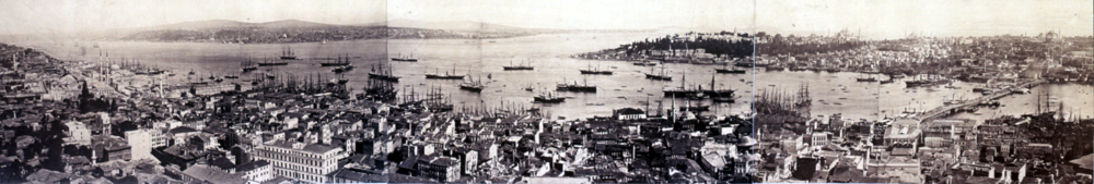
The location of Byzantium attracted Constantine I in 324 after a prophetic dream was said to have identified the location of the city; but the true reason behind this prophecy was probably Constantine's final victory over Licinius at the Battle of Chrysopolis (Üsküdar) on the Bosphorus, on 18 September, 324, which ended the civil war between the Roman Co-Emperors, and brought an end to the final vestiges of the Tetrarchy system, during which Nicomedia (present-day İzmit, 100 km (62 mi) east of Istanbul) was the most senior Roman capital city.[16] Byzantium (now renamed as Nova Roma which eventually became Constantinopolis, i.e. "The City of Constantine") was officially proclaimed the new capital of the Roman Empire six years later, in 330. Following the death of Theodosius I in 395 and the permanent partition of the Roman Empire between his two sons, Constantinople became the capital of the Eastern Roman (Byzantine) Empire. As well as being the centre of an imperial dynasty, the unique position of Constantinople at the centre of two continents made the city a magnet for international commerce, culture and diplomacy. The Byzantine Empire was distinctly Greek in culture and became the centre of Greek Orthodox Christianity, while its capital was adorned with many magnificent churches, including the Hagia Sophia, once the world's largest cathedral.[17] The seat of the Patriarch of Constantinople, spiritual leader of the Eastern Orthodox Church, still remains in the Fener (Greek: Phanar) district of Istanbul.[18]
In 1204, the Fourth Crusade was launched to capture Jerusalem, but had instead turned on Constantinople, which was sacked and desecrated.[19] The city subsequently became the centre of the Catholic Latin Empire, created by the crusaders to replace the Orthodox Byzantine Empire, which was divided into a number of splinter states, of which the Empire of Nicaea was to recapture Constantinople in 1261 under the command of Michael VIII Palaeologus.

In the last decades of the Byzantine Empire, the city had decayed as the Byzantine state became increasingly isolated and financially bankrupt, its population had dwindled to some thirty or forty thousand people whilst large sections remained uninhabited.[20] Due to the ever increasing inward turn the Byzantines took, many facets of their surrounding empire were now falling apart, leaving them vulnerable to attack. Ottoman Turks began a strategy by which they took selected towns and smaller cities over time, enveloping Bursa in 1326, Nicomedia in 1337, Gallipoli in 1354, and finally Adrianople in 1362. This essentially cut off Constantinople from its main supply routes, strangling it slowly.[21]
On 29 May 1453, Sultan Mehmed II "the Conqueror" captured Constantinople after a 53-day siege (during which the last Roman/Byzantine emperor, Constantine XI, died near the Porta Aurea while defending the city) and proclaimed that Constantinople was now the new capital of the Ottoman Empire. Sultan Mehmed's first duty was to rejuvenate the city economically, creating the Grand Bazaar and inviting the fleeing Orthodox and Catholic inhabitants to return. Captured prisoners were freed to settle in the city whilst provincial governors in Rumelia and Anatolia were ordered to send four thousand families to settle in the city, whether Muslim, Christian or Jew, to form a unique cosmopolitan society.[20] The Sultan also endowed the city with various architectural monuments, including the Topkapı Palace and the Eyüp Sultan Mosque. Religious foundations were established to fund the construction of grand imperial mosques (such as the Fatih Mosque which was built on the spot where the Church of the Holy Apostles once stood), adjoined by their associated schools, hospitals and public baths. Suleiman the Magnificent's reign of the Ottoman Empire from 1520 to 1566 was a period of great artistic and architectural achievements. The famous architect Sinan designed many mosques and other grand buildings in the city, while Ottoman arts of ceramics, calligraphy and miniature also flourished.

When the Republic of Turkey was founded in 1923 by Mustafa Kemal Atatürk, the capital was moved from Istanbul to Ankara. In the early years of the republic, Istanbul was overlooked in favour of the new capital. However, starting from the late 1940s and early 1950s, Istanbul underwent great structural change, as new public squares (such as Taksim Square), boulevards and avenues were constructed throughout the city; sometimes at the expense of the demolition of many historical buildings. Starting from the 1970s, the population of Istanbul began to rapidly increase, as people from Anatolia migrated to the city in order to find employment in the many new factories that were constructed at the outskirts of the sprawling metropolis. This sudden sharp rise in the city's population caused a large demand for housing development, and many previously outlying villages and forests became engulfed into the greater metropolitan area of Istanbul. Illegal construction, combined with corner-cutting methods, have accounted for the reason why 65% of the buildings in Istanbul are built without proper planning.[22] The concerns have increased due to the serious nature of the Izmit earthquake of August 17, 1999.[23]
[edit] Geography


[edit] Location
Istanbul is located in the north-west Marmara Region of Turkey. It encloses the southern Bosphorus which places the city on two continents—the western portion of Istanbul is in Europe, while the eastern portion is in Asia. The city boundaries cover a surface area of 1,830.92 square kilometres (707 sq mi), while the metropolitan region, or the Province of Istanbul, covers 6,220 square kilometres (2,402 sq mi).
[edit] Geology
Istanbul is situated near the North Anatolian fault line, which runs from northern Anatolia to the Marmara Sea. Two tectonic plates, the African and the Eurasian, push against each other here. This fault line has been responsible for several deadly earthquakes in the region throughout history. In 1509 a catastrophic earthquake caused a tsunami which broke over the sea-walls of the city, destroying over 100 mosques and killing 10,000 people. In 1766 the Eyüp Sultan Mosque was largely destroyed. The 1894 earthquake caused the collapse of many parts of the Grand Bazaar. A devastating earthquake on August 17, 1999, with its epicenter in nearby Izmit, left 18,000 dead and many more homeless.[24] In all of these earthquakes, the devastating effects are a result of the building density and poor construction of buildings. Seismologists predict another earthquake, possibly measuring magnitude 7.0, occurring before 2025.[25]
[edit] Flora
Istanbul like the Marmara region it is situated in is characterized by a temperate climate as well as a "transitional climate", midway between that of the oceanic climate of the Black Sea, the humid continental climate of the Balkan peninsula and the mediterranean climate of the southwest. This is also reflected in its plant geography since flora of these three regions flourish here. Istanbul is one of the provinces that best illustrates this aspect of the Marmara region. Thanks to the constantly very humid climate of Istanbul, plants of the Europe-Siberia region are concentrated here, especially in the northern areas near the Black Sea coast. An increase in mediterranean flora is observed in the warmer areas to the south of the city especially on the Princes' Islands, the only place in Istanbul with a mediterranean vegetation. With around 2500 different natural plant species, Istanbul alone puts European countries such as the whole of the United Kingdom in the shade in this respect. Even more importantly, this means that in Istanbul approximately one-fourth of the more than ten thousand documented plants that grow naturally in Turkey; some of these plants are endemic, in other words, they live only in Istanbul and nowhere else in the whole world.[26]

[edit] Climate
Istanbul has a temperate climate, though a plausible argument can be made that under the Köppen climate classification, Istanbul has a humid subtropical climate.
In summer the weather in Istanbul is hot and humid, the temperature between June and September averaging 28°C (82°F). During winter it is cold, wet and often snowy, averaging 5°C (42°F). Average annual precipitation is 693 mm (27.2 inches). Summer is by far the driest season, although there is no real summer drought as rain does occur all year round, and so the climate cannot be considered mediterranean. Snowfall is quite common between the months of December and March, snowing for a week or two, but it can be heavy once it snows. The city is also quite windy, having an average wind speed of 17 km/h (11 mph).[27]
| Month | Jan | Feb | Mar | Apr | May | Jun | Jul | Aug | Sep | Oct | Nov | Dec | |
|---|---|---|---|---|---|---|---|---|---|---|---|---|---|
| Average high °C (°F) | 8 (46) |
9 (48) |
11 (52) |
17 (63) |
21 (70) |
26 (79) |
28 (82) |
28 (82) |
25 (77) |
19 (66) |
15 (59) |
11 (52) |
|
| Average low °C (°F) | 3 (37) |
3 (37) |
4 (39) |
8 (46) |
12 (54) |
16 (61) |
18 (64) |
18 (64) |
15 (59) |
12 (54) |
8 (46) |
5 (41) |
|
| Precipitation mm (inches) | 99 (3.9) |
66 (2.6) |
61 (2.4) |
48 (1.89) |
31 (1.22) |
20 (0.79) |
20 (0.79) |
25 (0.98) |
41 (1.61) |
71 (2.8) |
89 (3.5) |
122 (4.8) |
|
| Source: Weather.com[28] January 6, 2009 | |||||||||||||
[edit] City arrangement
Istanbul's districts are divided into three main areas:

- The historic peninsula of old Istanbul corresponds approximately to the extent of Constantinople in the 15th century; it comprises the districts of Eminönü and Fatih. This area lies on the southern shores of the Golden Horn, which separates the old city center from the northern and younger parts of the European side. The historic peninsula ends with the Theodosian Land Walls in the west. The peninsula is surrounded by the Sea of Marmara on the south and the entrance of the Bosphorus on the east.
- North of the Golden Horn are the historical Beyoğlu and Beşiktaş districts, where the last Sultan's palace is located, followed by a chain of former villages such as Ortaköy and Bebek along the shores of the Bosphorus. On both the European and Asian sides of the Bosphorus, wealthy Istanbulites built luxurious chalet mansions, called yalı, which were used as summer residences.
- The districts of Üsküdar (ancient Chrysopolis) and Kadıköy (ancient Chalcedon) which are located on the Asian side were originally separate cities (like the district of Beyoğlu (medieval Pera) on the European side also used to be.) These cities have eventually been absorbed by Istanbul and have become its districts. Today, the Asian side of the city has numerous modern residential areas and business districts, and is home to around one-third of Istanbul's population.

To the west, to the east and to the north, Istanbul extends far beyond its historical quarters. The tallest office and residential towers rise particularly in the quarters of Levent, Etiler and Maslak on the European side, and in the quarter of Kozyatağı on the Asian side. Due to Istanbul's exponential growth during the second half of the 20th century, a significant portion of the city consists of gecekondus, a Turkish word created in the 1940s meaning "built overnight" and refers to the illegally constructed squatter buildings that comprise entire neighborhoods and run rampant in the outskirts of Turkey’s largest cities; especially Istanbul, Ankara, İzmir, and Bursa. According to the official definition stated in the Gecekondus Act of 1966, these neighborhoods are typically built on abandoned land or on lands owned by others, without the permission of the landowner or the Municipality, and the construction methods do not follow the official rules and regulations.
[edit] Districts
Istanbul Province has 32 districts, of which 27 form the city proper of Istanbul, also called Greater Istanbul, administered by the Istanbul Metropolitan Municipality (or Municipality of Metropolitan Istanbul) (Turkish: İstanbul Büyükşehir Belediyesi).
[edit] Administration
[edit] Organization

The mayor of Istanbul, currently Kadir Topbaş, serves as the prefect of the city.[29] The governor of Istanbul province is Muammer Güler.[30] Istanbul is a home rule city and municipal elections are mainly partisan. The metropolitan model of governance has been used with the establishment of metropolitan administration in 1930. The metropolitan council is responsible for all authority when it comes to making city decisions.[31] The metropolitan government structure consists of three main organs: (1) The Metropolitan Mayor (elected every five years), (2) The Metropolitan Council (decision making body with the mayor, district Mayors, and one fifth of the district municipal councilors), (3) The metropolitan executive committee. There are three types of local authorities: (1) municipalities, (2) special provincial administrations, (3) village administrations. Among the local authorities, municipalities are gaining greater importance with the rise in urbanization.
[edit] Demographics

The population of the metropolis more than tripled during the 25 years between 1980 and 2005. Roughly 70% of all Istanbulites live in the European section and around 30% in the Asian section. Due to high unemployment in the southeast of Turkey, many people from that region migrated to Istanbul, where they established themselves in the outskirts of the city. Migrants, predominantly from eastern Anatolia arrive in Istanbul expecting improved living conditions and employment, which usually end with little success. This results each year with new gecekondus at the outskirts of the city, which are later developed into neighbourhoods and integrated into the greater metropolis.
The city has a population of 11,372,613 residents according to the latest count as of 2007,[1] and is one of the largest cities in the world today. The rate of population growth in the city is currently at 3.45% a year on average, mainly due to the influx of people from the surrounding rural areas. Istanbul's population density of 2,742 people per square mile (1,700 per square km) far exceeds Turkey's 130 people per square mile (81 people per square km).[32]
The following overview shows the numbers of inhabitants by year. Population tallies up to 1914 are estimated with variations of up to 50% depending upon researcher. The numbers from 1927 to 2000 are results of censuses. The numbers of 2005 and 2006 are based on computer simulation forecasts. The doubling of the population of Istanbul between 1980 and 1985 is due to a natural increase in population as well as the expansion of municipal limits.

|
|
|
|
[edit] Religion
[edit] Overview

The urban landscape of Istanbul is shaped by many communities. The religion with the largest community of followers is Islam. Religious minorities include Greek Orthodox Christians, Armenian Christians, Catholic Levantines and Sephardic Jews. According to the 2000 census, there were 2691 active mosques, 123 active churches and 26 active synagogues in Istanbul; as well as 109 Muslim cemeteries and 57 non-Muslim cemeteries. Some districts have sizeable populations of these ethnic groups, such as the Kumkapı district which has a sizeable Armenian population, the Balat district which has a sizeable Jewish population, the Fener district which has a sizeable Greek population, and some neighbourhoods in the Nişantaşı and Beyoğlu districts which have sizeable Levantine populations. In some quarters, such as Kuzguncuk, an Armenian church sits next to a synagogue, and on the other side of the road a Greek Orthodox church is found beside a mosque.
The seat of the Patriarch of Constantinople, spiritual leader of the Greek Orthodox Church is located in the Fener (Phanar) district. Also based in Istanbul are the archbishop of the Turkish-Orthodox community, an Armenian archbishop, and the Turkish Grand-Rabbi. A number of places reflect past movements of different communities into Istanbul, most notably Arnavutköy (Albanian village), Polonezköy (Polish village) and Yenibosna (New Bosnia).
[edit] Muslims

The Muslims are the largest religious group in Istanbul. Among them, the Sunnis form the most populous sect, while a number of the local Muslims are Alevis. In 2007 there were 2,944 active mosques in Istanbul.[34]
Istanbul was the final seat of the Islamic Caliphate, between 1517 and 1924, when the Caliphate was dissolved and its powers were handed over to the Turkish Parliament. On September 2, 1925, the tekkes and tarikats were banned, as their activities were deemed incompatible with the characteristics of the secular democratic Republic of Turkey; particularly with the secular education system and the laicist state's control over religious affairs through the Religious Affairs Directorate. Most followers of Sufism and other forms of Islamic mysticism practiced clandestinely afterwards, and some of these sects still boast numerous followers. In order to avoid the still valid prohibition, these organisations represent themselves as "cultural associations."
[edit] Christians

The city has been the seat of the Ecumenical Patriarchate since the 4th century AD, and continues to serve as the seat of some other Orthodox churches, such as the Turkish Orthodox Church and the Armenian Patriarchate. The city was formerly also the seat of the Bulgarian Exarchate, before its autocephaly was recognized by other Orthodox churches.
The everyday life of the Christians, particularly the Greeks and Armenians living in Istanbul changed significantly following the bitter conflicts between these ethnic groups and the Turks during the fall of the Ottoman Empire, which began in the 1820s and continued for a century. The conflicts reached their culmination in the decade between 1912 and 1922; during the Balkan Wars, the First World War and the Turkish War of Independence. The city's Greek Orthodox community was exempted from the population exchange between Greece and Turkey in 1923. However, a series of special restrictions and taxes during the years of the Second World War (see, e.g., Varlık Vergisi), and the Istanbul Pogrom of 1955 which caused the deaths of 15 Greeks and the injury of 32 others, greatly increased emigration from Istanbul to Greece. In 1964, all Greeks without Turkish citizenship residing in Turkey (around 12,000)[35] were deported. Today, most of Turkey's remaining Greek and Armenian minorities live in or near Istanbul. The number of the local Turkish Armenians in Istanbul today amount to approximately 45,000[36] (not including the nearly 40,000 Armenian workers in Turkey who came from Armenia after 1991 and mostly live and work in Istanbul);[37] while the Greek community, which amounted to 150,000 citizens in 1924,[38] currently amounts to approximately 4,000 citizens.[36] There are also 60,000 Istanbulite Greeks who currently live in Greece but continue to retain their Turkish citizenship.[36] Beside the mostly Catholic Levantines, who are the descendants of European (Genoese, Venetian and French) traders who established trading outposts during the Byzantine and Ottoman periods, there is also a small, scattered number of Bosphorus Germans living in Istanbul.
[edit] Jews

The Sephardic Jews have lived in the city for over 500 years, see the history of the Jews in Turkey. They fled the Iberian Peninsula during the Spanish Inquisition of 1492, when they were forced to convert to Christianity after the fall of the Moorish Kingdom of Andalucia. The Ottoman Sultan Bayezid II (1481-1512) sent a sizable fleet to Spain under the command of Kemal Reis in order to save the Sephardic Jews. More than 200,000 fled first to Tangier, Algiers, Genova and Marseille, later to Salonica and finally to Istanbul. The Sultan granted over 93,000 of these Spanish Jews to take refuge in the Ottoman Empire. Another large group of Sephardic Jews came from southern Italy which was under Spanish control. The İtalyan Sinagogu (Italian Synagogue) in Galata is mostly frequented by the descendants of these Italian Jews in Istanbul, where more than 20,000 Sephardic Jews still remain today. Altogether 20 active synagogues are to be found in the city, the most important of them being the Neve Shalom Synagogue inaugurated in 1951, in the Beyoğlu quarter. The Turkish Grand Rabbi in Istanbul (currently Ishak Haleva) presides over community affairs. The Sephardic Jews of Iberia and Italy contributed much to the rising power of the Ottoman Empire by introducing new ideas, methods and craftsmanship. The first Gutenberg press in Istanbul was established by the Sephardic Jews in 1493, who excelled in many areas, particularly medicine, trade and banking. There is also a relatively smaller and more recent community of Ashkenazi Jews in Istanbul who continue to live in the city since the 19th century. A second large wave of Ashkenazi Jews came to Istanbul during the 1930s and 1940s following the rise of Nazism in Germany which persecuted the Ashkenazi Jews of central and eastern Europe.
[edit] Economy

Istanbul has always been the center of the country's economic life because of its location as an international junction of land and sea trade routes. The opening of specific markets in the city during the 1980s further strengthened the city's economic status. Inaugurated at the beginning of 1986, the Istanbul Stock Exchange (ISE) is the sole securities market of Turkey.

Today, the city generates 55% of Turkey's trade and 45% of the country's wholesale trade, and generates 21.2% of Turkey's gross national product. Istanbul contributes 40% of all taxes collected in Turkey and produces 27.5% of Turkey's national product. In 2005 the City of Istanbul had a GDP of $133 billion.[39] In 2005 companies based in Istanbul made exports worth $41,397,000,000 and imports worth $69,883,000,000; which corresponded to 56.6% and 60.2% of Turkey's exports and imports, respectively, in that year.[40]
According to Forbes magazine, Istanbul had a total of 35 billionaires as of March 2008 (up from 25 in 2007), ranking 4th in the world behind Moscow (74 billionaires), New York City (71 billionaires) and London (36 billionaires).[41]
Istanbul is also Turkey's largest industrial center. It employs approximately 20% of Turkey's industrial labor and contributes 38% of Turkey's industrial workspace. Istanbul and its surrounding province produce cotton, fruit, olive oil, silk, and tobacco. Food processing, textile production, oil products, rubber, metal ware, leather, chemicals, pharmaceuticals, electronics, glass, machinery, automotive, transport vehicles, paper and paper products, and alcoholic drinks are among the city's major industrial products.

Istanbul is one of the most important tourism spots of Turkey. There are thousands of hotels and other tourist oriented industries in the city, catering to both vacationers and visiting professionals. In 2006 a total of 23,148,669 tourists visited Turkey, most of whom entered the country through the airports and seaports of Istanbul and Antalya.[42] The total number of tourists who entered Turkey through Atatürk International Airport and Sabiha Gökçen International Airport in Istanbul reached 5,346,658, rising from 4,849,353 in 2005.[43] Istanbul is also one of the world's major conference destinations and is an increasingly popular choice for the world's leading international associations.[44]
[edit] Infrastructure
[edit] Health and medicine
The city has many public and private hospitals, clinics and laboratories within its bounds and numerous medical research centers. Many of these facilities have high technology equipment, which has contributed to the recent upsurge in "medical tourism" to Istanbul,[45] particularly from West European countries like the United Kingdom and Germany where governments send patients with lower income to the city for the relatively inexpensive service of high-tech medical treatment and operations.[46] Istanbul has particularly become a global destination for laser eye surgery and plastic surgery.[45] The city also has an Army Veterans Hospital in the military medical center.
Pollution-related health problems increase especially in the winter, when the combustion of heating fuels increase. The rising number of new cars in the city and the slow development of public transportation often cause urban smog conditions. Mandatory use of unleaded gas was scheduled to begin only in January 2006.[47]
[edit] Utilities

The first water supply systems which were built in Istanbul date back to the foundation of the city. Two of the greatest aqueducts built in the Roman period are the Mazulkemer Aqueduct and the Valens Aqueduct. These aqueducts were built in order to channel water from the Halkalı area in the western edge of the city to the Beyazıt district in the city center, which was known as the Forum Tauri in the Roman period.[48] After reaching the city center, the water was later collected in the city's numerous cisterns, such as the famous Philoxenos (Binbirdirek) Cistern and the Basilica (Yerebatan) Cistern. Sultan Suleiman the Magnificent commissioned Sinan, his engineer and architect-in-chief, to improve the water needs of the city. Sinan constructed the Kırkçeşme Water Supply System in 1555.[48] In later years, with the aim of responding to the ever-increasing public demand, water from various springs was channeled to the public fountains by means of small supply lines; see German Fountain.

Today, Istanbul has a chlorinated and filtered water supply and a sewage disposal system managed by the government agency İSKİ.[49] There are also several private sector organizations distributing clean water. Electricity distribution services are covered by the state-owned TEK. The first electricity production plant in the city, Silahtarağa Termik Santrali, was established in 1914 and continued to supply electricity until 1983.[50]
The Ottoman Ministry of Post and Telegraph was established in the city on 23 October 1840.[51] The first post office was the Postahane-i Amire near the courtyard of Yeni Mosque.[51] In 1876 the first international mailing network between Istanbul and the lands beyond the vast Ottoman Empire was established.[51] In 1901 the first money transfers were made through the post offices and the first cargo services became operational.[51] Samuel Morse received his first ever patent for the telegraph in 1847, at the old Beylerbeyi Palace (the present Beylerbeyi Palace was built in 1861–1865 on the same location) in Istanbul, which was issued by Sultan Abdülmecid who personally tested the new invention.[52] Following this successful test, installation works of the first telegraph line between Istanbul and Edirne began on 9 August 1847.[53] In 1855 the Telegraph Administration was established.[51] In July 1881 the first telephone circuit in Istanbul was established between the Ministry of Post and Telegraph in Soğukçeşme and the Postahane-i Amire in Yenicami.[53] On 23 May 1909, the first manual telephone exchange with a 50 line capacity was established in the Büyük Postane (Grand Post Office) of Sirkeci.[53]
[edit] Transportation
[edit] Airports

Istanbul has two international airports: The larger one is the Atatürk International Airport located in the Yeşilköy district on the European side, about 24 kilometres (15 mi) west from the city center. When it was first built, the airport used to be at the western edge of the metropolitan area but now lies within the city bounds.
The smaller one is the Sabiha Gökçen International Airport located in the Kurtköy district on the Asian side, close to the Istanbul Park GP Racing Circuit. It is situated approximately 20 kilometres (12 mi) east of the Asian side and 45 kilometres (28 mi) east of the European city center.
[edit] Motorways


The E80 and Trans European Motorway (TEM) are the three main motorway connections between Europe and Turkey. The motorway network around Istanbul is well developed and is constantly being extended. Motorways lead east to Ankara and west to Edirne.
There are also two express highways circling the city. The older one, the O1, is mostly used for inner city traffic; while the more recent one, the TEM highway, is mostly used by intercity or intercontinental traffic. The Bosphorus Bridge on O1 and the Fatih Sultan Mehmet Bridge on TEM establish the motorway connection between the European and the Asian sides of the Bosphorus.
Büyükdere Avenue is the main artery that runs through the central business districts of Levent and Maslak on the European side, and is also accessible through a number of subway stations.
[edit] Navigation
Sea transport is vital for Istanbul, as the city is practically surrounded by sea on all sides: the Sea of Marmara, the Golden Horn, the Bosphorus and the Black Sea. Many Istanbulites live on the Asian side of the city but work on the European side (or vice-versa) and the city's famous commuter ferries form the backbone of the daily transition between the two parts of the city - even more so than the two suspension bridges which span the Bosphorus. The commuter ferries, along with the high speed catamaran Seabus (Deniz Otobüsü), also form the main connection between the city and the Princes' Islands.

İDO (İstanbul Deniz Otobüsleri - Istanbul Sea Buses) was established in 1987 and operates the high speed catamaran Seabus which run between the European and Asian parts of Istanbul, also connecting the city with the Princes' Islands and other destinations in the Sea of Marmara. The Yenikapı High Speed Car Ferry Port on the European side, and the Pendik High Speed Car Ferry Port on the Asian side, are where the high speed catamaran "car ferries" are based. The car ferries which operate between Yenikapı (on the European side of Istanbul) and Bandırma reduce the driving time between Istanbul and İzmir and other major destinations on Turkey's Aegean coast by several hours; while those which operate between Yenikapı or Pendik (on the Asian side of Istanbul) and Yalova significantly reduce the driving time between Istanbul and Bursa or Antalya.

The port of Istanbul is the most important one in the country. The old port on the Golden Horn serves primarily for personal navigation, while Karaköy port in Galata is used by the large cruise liners. Regular services as well as cruises from both Karaköy and Eminönü exist to several port cities in the Mediterranean Sea and Black Sea. Istanbul's main cargo port is located in the Harem district on the Asian side of the city.
Istanbul also has several marinas of varying size for personal navigation, the largest of which are the Ataköy Marina on the European side and Kalamış Marina on the Asian side.
[edit] Railway

In 1883, a Belgian entrepreneur, Georges Nagelmackers, began rail service between Paris and Constantinople, using a steamship to ferry passengers from Varna to Constantinople. In 1889, a rail line was completed going through Bucharest to Constantinople, making the whole journey via land possible. The route was known as the Orient Express, made even more famous by the works of Agatha Christie and Graham Greene.[54]

Today, the Sirkeci Terminal of the Turkish State Railways (TCDD), which was originally opened as the terminus of the Orient Express, is the terminus of all the lines on the European side and the main connection node of the Turkish railway network with the rest of Europe. Currently, international connections are provided by the line running between Istanbul and Thessaloniki, Greece, and the Bosphorus Express serving daily between Sirkeci and Bucharest, Romania. Lines to Sofia, Belgrade, Budapest, and Chişinău are established over the Bosphorus Express connection to Bucharest. .
Beyond the Bosphorus, the Haydarpaşa Terminal on the Asian side serves lines running several times daily to Ankara, and less frequently to other destinations in Anatolia. The railway networks on the European and Asian sides are currently connected by the train ferry across the Bosphorus, which will be replaced by an underwater tunnel connection with the completion of the Marmaray project, scheduled for 2012. Marmaray (Bosphorus Rail Tunnel) will also connect the metro lines on the European and Asian parts of the city. Haydarpaşa Terminal was originally opened as the terminus of the Istanbul-Baghdad and Istanbul-Damascus-Medina railways.
[edit] Public
[edit] Urban rail transit
[edit] Nostalgic trams

By the end of 1990, a historic tram was put in service along İstiklal Avenue between Taksim and Tünel, which is a single 1.6 km-long line.
On 1 November 2003, another nostalgic tram line (T3) was reopened on the Anatolian part of Istanbul between Kadıköy and Moda. It has 10 stations on a 2.6 km long route. The trip takes 21 minutes.
[edit] Modern trams
[edit] Line T1
A fast tram (T1) was put in service in 1992 on standard gauge track with modern cars, connecting Sirkeci with Topkapı. The line was extended on one end from Topkapı to Zeytinburnu in March 1994, and on the other end from Sirkeci to Eminönü in April 1996. On 30 January 2005 it was extended from Eminönü to Fındıklı, crossing the Golden Horn through the Galata Bridge for the first time after 44 years. A final extension to Kabataş was opened in June 2006.

The line has 24 stations on a length of 14 km. Service was initially operated with 22 LRT vehicles built by ABB, now reassigned to other lines; while stations were provided with temporary high platforms. These vehicles were replaced by 55 low-floor Bombardier Flexity Swift trams in 2003. An entire trip takes 42 minutes. The daily transport capacity is 155,000 passengers. The amount of investment totaled US$110 million.
[edit] Line T2
In September 2006, a second tram line (T2) was added, running west from Zeytinburnu to Bağcılar. Service on this line is operated with 14 ABB LRT cars. Stations have high platforms at the level of the car floor.
[edit] Funiculars


Istanbul is served by two underground funicular railways, of very different ages and styles.
The older of these lines is the Tünel (1875), which is the oldest subterranean railway line in continental Europe, and the second oldest line in the world after the Underground (1863) in London (arguably third in the world, if one counts Brooklyn, New York's abandoned Atlantic Avenue Tunnel). The Tünel is 573 m long with an altitude difference of 60 m and no intermediate stations between Karaköy and Tünel Square. It has been continuously in service since 1875. Two trains run on a single rail every 3.5 minutes, and a trip takes 1.5 minutes. 15,000 people are transported daily.
A second funicular line, the Kabataş-Taksim Funicular, opened in June 2006, connecting Kabataş and Taksim. This system connects the Seabus station and the tram stop in Kabataş to the metro station at Taksim Square. It is about 600 meters long and climbs approximately 60 meters in 110 seconds.
[edit] Light rail
The Istanbul LRT is a light rail transit system consisting of 2 lines. The first line (M1) began service on 3 September 1989 between Aksaray and Kartaltepe. The line was further developed step-by-step and reached Atatürk Airport on December 20, 2002. The other line (T4) was opened in 2007 between Edirnekapı and Mescid-i Selam. There are 36 stations, including 12 underground and 3 viaduct stations, on the line's 32 km length. The lines are totally segregated from other traffic without level crossings and run underground for 10.2 km. Service is operated with LRT vehicles built by ABB in 1989.
[edit] Metro

The construction of the modern underground railway network of Istanbul began in 1992. The first line (M2) between Taksim and 4th Levent went into service on 16 September 2000. This line is 8.5 km long and has 6 stations, which all look similar but are in different colors. Currently there are 8 French built 4-car trains in service, which run every 5 minutes on average and transport 130,000 passengers daily. A trip along the entire line takes 12 minutes. The entire subway line was built by the cut-and-cover method to withstand an earthquake of up to 9.0 on the Richter magnitude scale.
A northern extension from 4th Levent to Ayazağa (Maslak) was opened in January 2009. The southern section of the metro from Taksim to Yenikapı, across the Golden Horn on a bridge and underground through the old city, has thus far been completed up to the Şişhane stop and is expected to become fully operational in 2009. It will be 5.4 km long, with four stations. At Yenikapı it will intersect with the extended light metro and the suburban train lines.
On the Asian side, construction of the line from Kadıköy to Kartal continues. The Marmaray tunnel (Bosporus undersea railway tunnel) will connect the metro lines of the Asian and European parts of the city. According to the scheduled construction timeline, the tunnel will enter service in 2012.
[edit] Suburban trains
A railway line runs between the main train station of the European part, the Sirkeci Terminal, and the Halkalı district towards the west of the city center, with 18 stations along its 30 km length. A single trip takes 48 minutes. Another suburban line runs on the Anatolian part from the main train station, the Haydarpaşa Terminal, to Gebze at the eastern end of the city. The 44 km long line has 28 stations and the trip takes 65 minutes. Electrified trains transport 13,000 passengers hourly on each line.
[edit] Architecture
Throughout its long history, Istanbul has acquired a reputation for being a cultural and ethnic melting pot. As a result, there are many historical mosques, churches, synagogues, palaces, castles and towers to visit in the city. Some of these historical structures, which draw millions to the city every year, reflect the heart and soul of Istanbul.[55]
[edit] Ancient Greek
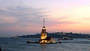
The famous Maiden's (Leander's) Tower, one of the symbols of Istanbul, was originally built by the ancient Athenian general Alcibiades in 408 BC to control the movements of the Persian ships in the Bosphorus strait.[56]
[edit] Roman

The most important monuments of Roman architecture in the city include the Column of Constantine (Turkish: Çemberlitaş), which was erected in 330 by Constantine the Great for marking the declaration of the new capital city of the Roman Empire[57] . The Mazulkemer Aqueduct, the Valens Aqueduct, the Column of the Goths at the Seraglio Point, the Milion which served for calculating the distances between Constantinople and other cities of the Roman Empire, and the Hippodrome of Constantinople which was built following the model of the Circus Maximus in Rome are other Roman era structures in the city. Construction of the Walls of Constantinople began under Constantine the Great,[58] who enlarged the previously existing walls of Byzantium in order to defend the new Roman capital city which quickly grew following its proclamation as Nova Roma. A new set of walls was built further west during the reign of Theodosius II, and rebuilt after an earthquake in 447 in their current shape.
[edit] Byzantine
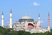
The early Byzantine architecture followed the classical Roman model of domes and arches, but further improved these architectural concepts, as evidenced with the Hagia Sophia, which is the largest structure on Sultanahmet Square in the Eminönü district. The Hagia Sophia was designed by Isidorus and Anthemius as the third church to rise on this location, between 532 and 537, following the Nika riots (532) during which the second church was destroyed (the first church, known as the Megala Ekklessia ("Great Church") was inaugurated by Constantius II in 360; the second church was inaugurated by Theodosius II in 405, while the third and current one was inaugurated by Justinian in 537). The Church of Saints Sergius and Bacchus (commonly known as the Little Hagia Sophia), which was the first church built by Justinian in Constantinople and edificed between 527 and 536, had earlier signaled such an improvement in the design of domed buildings, which require complex solutions for carrying the structure. The present-day Hagia Irene (which was originally built by Constantine in the 4th century, but was later enlarged by Justinian in the 6th century) and the Basilica Cistern are also from this period.

The most important churches which were built after the Byzantines recovered Constantinople from the Latin Crusaders in 1261 include the Pammakaristos Church and Chora Church. Also in this period, the Genoese Podestà of Galata, Montano de Marinis, built the Palazzo del Comune (1316),[59] an identical copy of the San Giorgio Palace in Genoa, which still stands in ruins on a parallel side street to the north of Bankalar Caddesi (Banks Street) in Galata, together with its adjacent buildings and numerous Genoese houses from the early 1300s. The Genoese also built the Galata Tower, which they named as Christea Turris (Tower of Christ), at the highest point of the citadel of Galata, in 1348.

[edit] Ottoman
The Ottoman Turks built the Anadoluhisarı on the Asian side of the Bosphorus in 1394, and the Rumelihisarı at the opposite (European) shore, in 1452, a year before the conquest of Constantinople. The main purpose of these castles, armed with the long range Balyemez (Faule Metze) cannons, was to block the sea traffic of the Bosphorus and prevent the support ships from the Genoese colonies on the Black Sea ports, such as Caffa, Sinop, and Amasra, from reaching Constantinople and helping the Byzantines during the Turkish siege of the city.[60] The first mosque on the European side of Istanbul was built inside the Rumeli Castle in 1452.

Following the Ottoman conquest of the city, Sultan Mehmed II initiated a wide scale reconstruction plan, which included the construction of grand buildings such as the Topkapı Palace, Grand Bazaar and the Yedikule (Seven Towers) Castle which guarded the main entrance gate of the city, the Porta Aurea (Golden Gate). The first grand mosque which was built in the city proper was the Eyüp Sultan Mosque in around 1459. The mosque was built on the site of the grave of Abu Ayyub al-Ansari, a companion of the Prophet Muhammad who had died outside the land walls of Constantinople (walls of Theodosius II) in 669,[61] during the early skirmishes which preluded the Arab siege (674-678) to take the city. The first imperial mosque inside the city walls was the Fatih Mosque (1470) which was built on the site of the Church of the Holy Apostles, an important Byzantine church originally edificed in the time of Constantine the Great. Many other imperial mosques were built in the following centuries, such as the famous Süleymaniye Mosque (1557) which was ordered by Suleiman the Magnificent and designed by the great Ottoman architect Sinan, and the famous Sultan Ahmet Mosque (1616) which is also known as the Blue Mosque for the blue tiles that adorn its interior. In the centuries following Mehmed II, many new important buildings, such as the Süleymaniye Mosque, Sultanahmet Mosque, Yeni Mosque and numerous others were constructed.

In the 18th and 19th centuries, traditional Ottoman architectural styles were gradually replaced by European styles, such as the Baroque style interiors of the Aynalıkavak Palace (1677–1679) and Nuruosmaniye Mosque (1748–1755, the first Baroque style mosque in the city, also famous for its Baroque fountain), and the 18th century Baroque additions to the Harem section of the Topkapı Palace. Following the Tanzimat reforms which effectively started Turkey's Europeanization process in 1839, new palaces and mosques were built in Neoclassical, Baroque and Rococo styles, or a mixture of all three, such as the Dolmabahçe Palace, Beylerbeyi Palace and Ortaköy (Mecidiye) Mosque[63].
Starting from the early 19th century, the areas around İstiklal Avenue were filled with grandiose embassy buildings belonging to prominent European states, and rows of European (mostly Neoclassical and later Art Nouveau) style buildings started to appear on both flanks of the avenue. Istanbul especially became a major center of the Art Nouveau (Liberty) movement in the late 19th and early 20th centuries, with famous architects of this style like Raimondo D'Aronco building many palaces and mansions in the city proper and on the Princes' Islands. His most important works in the city include several buildings of the Yıldız Palace complex, and the Botter House on İstiklal Avenue. The famous Camondo Stairs on Bankalar Caddesi (Banks Street) in Karaköy (Galata) is also a beautiful example of Art Nouveau architecture. Other important examples are the Hıdiv Kasrı[64] (Khedive Palace) on the Asian side of the Bosphorus, Flora Han in Sirkeci, and Frej Apartmanı[65] in the Şişhane quarter of Beyoğlu.[66]
[edit] Urbanism


The urban landscape is constantly changing. In the Greek, Roman and Byzantine periods, the city was largely made up of the historic peninsula of Constantinople, with the citadel of Galata (also called Sykae or Pera, present-day Beyoğlu) at north, and Chrysopolis (Üsküdar) and Chalcedon (Kadıköy) at east, across the Bosphorus. These were all independent cities back then. The present City of Istanbul can be considered the metropolitan area of old Constantinople, encompassing every single settlement around the original city, and expanding even further with the establishment of new neighbourhoods and districts since the 19th century.
Until the early 19th century, the city walls of Galata, the medieval Genoese citadel, used to stand. These Genoese fortifications, of which only the Galata Tower stands today, were demolished in the early 1800s to give way for a northwards expansion of the city, towards the neighbourhoods of Beşiktaş, Şişli, Nişantaşı, and beyond.
In the last decades, numerous tall structures were built around the city to accommodate a rapid growth in population. Surrounding towns were absorbed into Istanbul as the city rapidly expanded outwards. The tallest highrise office and residential buildings are mostly located in the northern areas of the European side, and especially in the business and shopping districts of Levent, Maslak, and Etiler which are situated between the Bosphorus Bridge and Fatih Sultan Mehmet Bridge. Levent and Etiler also have numerous upmarket shopping malls, like Kanyon, Metrocity, Akmerkez, Mayadrom and Mayadrom Uptown. The headquarters of Turkey's largest companies and banks are also located in this area.
Starting from the second half of the 20th century, the Asian side of Istanbul, which was originally a tranquil place full of seaside summer residences and elegant chalet mansions surrounded by lush and vast umbrella pine gardens, experienced a massive urban growth. The construction of the long, wide and elegant Bağdat Avenue, with its rows of upscale shops and restaurants, contributed much to the initial expansion in the area. The fact that these areas were largely empty until the 1960s also provided the chance for developing better infrastructure and a tidier urban planning when compared with most other residential areas in the city. But the real expansion of the Asian side came with the opening of Ankara Asfaltı, the Asian extension of the E5 highway, which is located to the north of Bağdat Avenue, parallel to the railway line. Another important factor in the recent growth of the Asian side of the city was migration from Anatolia. Today, more than 1/3 of the city's population live in the Asian side of Istanbul.
As a result of Istanbul's exponential growth during the second half of the 20th century, a significant portion of the city's outskirts consists of gecekondus, a Turkish word created in the 1940s meaning ‘built overnight’ and referring to the illegally constructed squatter buildings that comprise entire neighbourhoods and run rampant outside the historic centers of Turkey's largest cities, especially Istanbul, Ankara, İzmir, and Bursa. At present, some gecekondu areas are being gradually demolished and replaced by modern mass-housing compounds.
[edit] Life in the city

[edit] Arts and culture
Istanbul is becoming increasingly colorful in terms of its rich social, cultural, and commercial activities. While world famous pop stars fill stadiums, activities like opera, ballet and theater continue throughout the year. During seasonal festivals, world famous orchestras, chorale ensembles, concerts and jazz legends can be found often playing to a full house. The Istanbul International Film Festival is one of the most important film festivals in Europe, while the Istanbul Biennial is another major event of fine arts.

Istanbul Modern, frequently hosts the exhibitions of renowned Turkish and foreign artists. Pera Museum and Sakıp Sabancı Museum have hosted the exhibitions of world famous artists and are among the most important private museums in the city. The Doğançay Museum - Turkey’s first contemporary art museum - is dedicated almost exclusively to the work of its founder Burhan Doğançay. The Rahmi M. Koç Museum on the Golden Horn is an industrial museum that exhibits historic industrial equipment such as cars and locomotives from the 1800s and early 1900s, as well as boats, submarines, aircraft, and other similar vintage machines from past epochs.
Istanbul Archaeology Museum, established in 1881, is one of the largest museums of its kind in the world. The museum contains more than 1,000,000 archaeological pieces from the Mediterranean basin, the Balkans, the Middle East, North Africa and Central Asia. Istanbul Mosaic Museum contains the late Roman and early Byzantine floor mosaics and wall ornaments of the Great Palace of Constantinople. The nearby Turkish and Islamic Arts Museum displays a vast collection of items from various Islamic civilizations. Sadberk Hanım Museum contains a wide variety of artifacts, dating from the earliest Anatolian civilizations to the Ottomans.

Occasionally, in November, the Silahhane (Armory Hall) of Yıldız Palace hosts the Istanbul Antiques Fair, which brings together rare pieces of antiques from the Orient and Occident. The multi-storey Mecidiyeköy Antikacılar Çarşısı (Mecidiyeköy Antiques Bazaar) in the Mecidiyeköy quarter of Şişli is the largest antiques market in the city, while the Çukurcuma neighbourhood of Beyoğlu has rows of antiques shops in its streets. The Grand Bazaar, edificed between 1455–1461 by the order of Sultan Mehmed the Conqueror also has numerous antiques shops, along with shops selling jewels, carpets and other items of art and artisanship. Historic and rare books are found in the Sahaflar Çarşısı near Beyazıt Square, and it is one of the oldest book markets in the world, and has continuously been active in the same location since the late Roman, Byzantine and Ottoman periods.
A significant culture has been developed around what is known as a Turkish Bath. It was a culture of leisure during the Ottoman period, the finest example being the Çemberlitaş Hamamı (1584) in Istanbul, located on the Çemberlitaş (Column of Constantine) Square.[67]
Live shows and concerts are hosted at a number of locations including historical sites such as the Hagia Irene, Rumeli Fortress, Yedikule Castle, the courtyard of Topkapı Palace, and Gülhane Park; as well as the Atatürk Cultural Center, Cemal Reşit Rey Concert Hall and other open air and modern theater halls.
[edit] Media
The first Turkish newspaper, Takvim-i Vekayi, was printed on August 1, 1831 in the Bâbıâli (Bâb-ı Âli, meaning The Sublime Porte) district. Bâbıâli became the main center for print media. Istanbul is also the printing capital of Turkey with a wide variety of domestic and foreign periodicals expressing diverse views, and domestic newspapers are extremely competitive. Most nationwide newspapers are based in Istanbul, with simultaneous Ankara and İzmir editions.[47] Major newspapers with their headquarters in Istanbul include Hürriyet, Milliyet, Sabah, Radikal, Cumhuriyet, Zaman, Türkiye, Akşam, Bugün, Star, Dünya, Tercüman, Güneş, Vatan, Posta, Takvim, Vakit, Yeni Şafak, Fanatik and Turkish Daily News. There are also numerous local and national TV and radio stations located in Istanbul, such as CNBC-e, CNN Türk, MTV Türkiye, Fox Türkiye, Fox Sports Türkiye, NTV, Kanal D, ATV, Show TV, Star TV, Cine5, SKY Türk, TGRT Haber, Kanal 7, Kanal Türk, Flash TV and many others. In the city of Istanbul, there are over a hundred FM-radio stations. [68]
[edit] Recreation
| “ | If one had but a single glance to give the world, one should gaze on Istanbul. | ” |
Traditional beach resorts had gradually disappeared due to water pollution. Recently, however, old places have reopened in the city. The most popular places for swimming in the city are in Bakırköy, Küçükçekmece, Sarıyer and the Bosphorus. Outside the city are the Marmara Sea's Princes' Islands, Silivri and Tuzla; as well as Kilyos and Şile on the Black Sea.
The Princes' Islands (Prens Adaları) are a group of islands in the Marmara Sea, south of the quarters Kartal and Pendik. Pine and stone-pine wooden neoclassical and art nouveau-style Ottoman era summer mansions from the 19th and early 20th centuries, horse-drawn carriages (motor vehicles are not permitted) and seafood restaurants make them a popular destination. They can be reached by ferry boats or high-speed catamaran Seabus (Deniz otobüsü) from Eminönü and Bostancı. Of the nine islands, only five are settled.
Şile is a distant and well-known Turkish seaside resort on the Black Sea, 50 kilometres (31 mi) from Istanbul, where unspoiled white sand beaches can be found. Kilyos is a small calm seaside resort not far from the northern European entrance of the Bosphorus at the Black Sea. The place has good swimming possibilities and has become popular in the recent years among the inhabitants of Istanbul as a place for excursions. Kilyos offers a beach park with seafood restaurants and night clubs, being particularly active in the summer with many night parties and live concerts on the beach.
[edit] Shopping
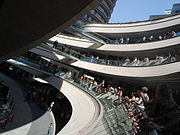
Istanbul has numerous historic shopping centers, such as the Grand Bazaar (1461), Mahmutpaşa Bazaar (1462) and the Egyptian Bazaar (1660). The first modern shopping mall was Galleria Ataköy (1987), which was followed by dozens of others in the later decades, such as Akmerkez (1993) which is the only mall to win both "Europe's Best" and "World's Best" awards by the ICSC; Metrocity (2003); Cevahir Mall (2005) which is the largest mall in Europe; and Kanyon Mall (2006) which won the 2006 Cityscape Architectural Review Award for its interesting design. İstinye Park (2007) and City's Nişantaşı (2008) are two new malls which target high-end consumers and are almost exclusively dedicated to world-famous fashion brands.
[edit] Restaurants
Along with the traditional Turkish restaurants, many European and Far Eastern restaurants and numerous other cuisines are also thriving in the city.

Most of the city's historic winehouses (meyhane in Turkish) and pubs are located in the areas around İstiklal Avenue in Beyoğlu. The 19th century Çiçek Pasajı (literally Flower Passage in Turkish, or Cité de Péra in French) on İstiklal Avenue, which has many historic meyhanes, pubs and restaurants, was built by Hristaki Zoğrafos Efendi at the former site of the Naum Theatre and was inaugurated in 1876. The famous Nevizâde Street, which has rows of historic meyhanes next to each other, is also in this area.

Other historic pubs are found in the areas around Tünel Pasajı and the nearby Asmalımescit Sokağı. Some historic neighbourhoods around İstiklal Avenue have recently been recreated, with differing levels of success such as Cezayir Sokak near Galatasaray Lisesi, which became unofficially known as La Rue Française and has rows of pubs including francophone ones, cafés and restaurants playing live music.
Istanbul is also famous for its historic seafood restaurants. Many of them were originally established by the local Greeks. The most popular seafood restaurants are generally found along the shores of the Bosphorus and by the Marmara Sea shore towards the south of the city. The Princes' Islands in the Sea of Marmara (Büyük Ada, Heybeli Ada, Kınalı Ada, Burgaz Ada) and Anadolu Kavağı near the northern entrance of the Bosphorus towards the Black Sea (close to Yoros Castle, which was also known as the Genoese Castle due to Genoa's possession of it in the mid-15th century) also have many historic seafood restaurants.
[edit] Night life

There are many night clubs, pubs, restaurants and taverns with live music in the city. The night clubs, restaurants and bars increase in number and move to open air spaces in the summer. The areas around Istiklal Avenue and Nişantaşı offer all sorts of cafés, restaurants, pubs and clubs as well as art galleries, theaters and cinemas.
The most popular open air summer time seaside night clubs are found on the Bosphorus, such as Reina, Sortie and Anjelique in the Ortaköy district. Babylon and Nu Pera in Beyoğlu are popular night clubs both in the summer and in the winter, while Istanbul Arena in Maslak frequently hosts the live concerts of famous singers and bands from all corners of the world. Parkorman in Maslak hosted the Isle of MTV Party in 2002 and is a popular venue for live concerts and rave parties in the summer. Q Jazz Bar in Ortaköy offers live jazz music in a stylish environment.
[edit] Education

[edit] Universities

Istanbul holds some of the finest institutions of higher education in Turkey, including more than 20 public and private universities. Most of the reputable universities are public, but in recent years there has also been an upsurge in the number of private universities. Istanbul University (1453) is the oldest Turkish educational institution in the city, while Istanbul Technical University (1773) is the world's second-oldest technical university dedicated entirely to engineering sciences. Other prominent state universities in Istanbul are the Boğaziçi University (1863), Mimar Sinan University of Fine Arts (1882), Marmara University (1883), Yıldız Technical University (1911) and Galatasaray University (1992). The major private universities in the city include Koç University (1993), Sabancı University (1994), Yeditepe University (1996), Bilgi University (1996), Işık University (1996), Fatih University (1996), Maltepe University (1997), Beykent University (1997), Kadir Has University (1997), Haliç University (1998), Bahçeşehir University (1998), Okan University (1999), and Istanbul Commerce University (2001).
[edit] High schools

Galatasaray Lisesi, established in 1481 as Galata Sarayı Enderun-u Hümayunu (Galata Palace Imperial School) and later known as Galatasaray Mekteb-i Sultanisi (Galatasaray School of the Sultans) is the oldest Turkish high school in Istanbul and the second oldest Turkish educational institution in the city after Istanbul University which was established in 1453. Galatasaray gives education primarily in Turkish and French, but there are also courses in English, Italian, Latin, Greek, Ottoman Turkish, Persian and Arabic.

İstanbul Lisesi, also commonly known as İstanbul Erkek Lisesi (established in 1884), abbreviated İEL, is one of the oldest and internationally renowned high schools of Turkey located in İstanbul. The school is considered among the elite of Turkish public high schools. Germany recognizes the school as a Deutsche Auslandsschule (German International School).
Almost all Turkish private high schools and universities in Istanbul teach in English, German or French as the primary foreign language, usually accompanied by a secondary foreign language.
Fen Liseleri (Science High Schools) were established with the aim of providing education to exceptionally gifted students in mathematics, physics, chemistry and other sciences. These are boarding schools which offer a three-year program with a curriculum that emphasises science and mathematics. The schools have a standard class size of 24 pupils and the language of instruction is Turkish.
Anadolu Liseleri (Anatolian High Schools) were originally furnished for the Turkish children who returned home from foreign countries, such as the Üsküdar Anadolu Lisesi with German as the primary foreign language and technical instruction in German. Kadıköy Anadolu Lisesi on the Asian side, however, is one of the first six special Ministry of Education Colleges (Maarif Koleji) established in 1950s in big cities across Turkey. Those English-medium colleges, too, were renamed as "Anadolu Lisesi" in subsequent decades.

Kuleli Military High School is the only military high school in Istanbul, located in Çengelköy district. The military high school have superior facilities, and classes are as little as one-third the size of those in civilian high schools. Scholastic performance is closely monitored. A summer camp is devoted to sports and military instruction. It has a four year program, and after completion, cadets from the school enter Kara Harp Okulu. A small number of cadets also enter the school from civilian high schools. Military high schools are all male schools, so all female cadets at Kara Harp Okulu come from civilian high schools. Kara Harp Okulu is the only source of commissioned officers for the Turkish Army. After graduation cadets are required to serve for 15 years.

There are many foreign high schools in Istanbul, most of which were established in the 19th century in order to give education to the foreigners residing in Istanbul, or to local Stambouliotes with European roots. Following the establishment of the Republic of Turkey, most of these schools went under the administration of the Turkish Ministry of Education, but some of them still have considerable foreign administration, such as the Liceo Italiano (Özel İtalyan Lisesi, 1861) which is still regarded as an Italian state school by the government of Italy and continues to receive funding and teachers from Rome. The oldest such school is the French Lycée Saint-Benoit, established in 1783 with its current name (the school's roots go back to 1362). Robert College, established in 1863, is the world's oldest American school outside the United States. The first international school in the city, Istanbul International Community School, was founded in 1911 to educate the children of international professors at Robert College.[69] The name of the school was Robert College Community School until 1979, when it was changed to its current name, Istanbul International Community School (IICS).[70] With a law passed by the Turkish Parliament in 1971, foreign universities in Turkey (i.e. Boğaziçi University which was originally the university section of Robert College) went under the jurisdiction of the Turkish state, but high schools were allowed to operate with foreign headmasters and curricula, such as the high school section of Robert College which continues to have an American headmaster. Other similar examples are the Lycée Notre Dame de Sion (1856), Deutsche Schule Istanbul (1868), Lycée Saint-Joseph (1870), Üsküdar American Academy (1876), Lycée Saint-Michel (1886), Sankt Georg Austrian High School (1892), Zappeion Greek Girls' High School, Italian Girls' Junior High School, Esayan Armenian Girls' High School, Saint Jean Baptiste French Boys' School, Saint Pulcherie Jesuit School, Zoğrafyon Greek Boys' High School and the British Girls' School. Phanar Greek Orthodox College (Fener Rum Erkek Lisesi), established in 1454, is the oldest surviving and most prestigious Greek high school in the city. Many Ottoman viziers as well as Wallachian and Moldavian princes appointed by the Ottoman state were graduated from this school.
[edit] Libraries
Istanbul has numerous libraries, many of which contain vast collections of historic documents from the Roman, Byzantine and Ottoman periods, as well as from other civilizations of the past. The most important libraries in terms of historic document collections include the Topkapı Palace Library, Library of the Archaeological Museum, Library of the Naval Museum, Beyazıt State Library, Nuruosmaniye Library, Süleymaniye Library, Istanbul University Library, Köprülüzade Fazıl Ahmed Paşa Library, Atatürk Library and Çelik Gülersoy Library.
[edit] Sports


During the Roman and Byzantine periods, the most important sporting events were the chariot races that were held at the Hippodrome of Constantinople, which had a capacity to accommodate more than 100,000 spectators.
Today, sports like football, basketball and volleyball are very popular in the city. In addition to Galatasaray, Fenerbahçe and Beşiktaş, which field teams in multiple sports, several other clubs have also excelled in particular team sports; such as Efes Pilsen, Fenerbahçe Ülker, Galatasaray Cafe Crown, Türk Telekom and Beşiktaş Cola Turka in basketball; or Eczacıbaşı, Vakıfbank, Fenerbahçe and Galatasaray in volleyball.
The Atatürk Olympic Stadium, the largest multi-purpose stadium in Turkey, is a 5-star UEFA stadium and a first-class venue for track and field; having reached the highest required standards set by the International Olympic Committee and sports federations such as the IAAF, FIFA and UEFA. The stadium hosted the 2005 UEFA Champions League Final.
The Şükrü Saracoğlu Stadium, which is also a 5-star UEFA stadium, will host the 2009 UEFA Cup Final.
The Abdi İpekçi Arena hosted the Final of EuroBasket 2001, and was also the venue for the 1992 Euroleague Final Four.
The Sinan Erdem Dome, the largest multi-purpose indoor arena in Turkey, will host the Final of the 2010 FIBA World Basketball Championship, and will also be the venue for the 2012 IAAF World Indoor Championships and the 2012 FINA Short Course World Championships.
Istanbul hosts several annual motorsports events, such as the Formula One Turkish Grand Prix, the MotoGP Grand Prix of Turkey, the FIA World Touring Car Championship, the GP2 and the Le Mans Series 1,000 km (621 mi) races at the Istanbul Park GP Racing Circuit.
From time to time Istanbul also hosts the Turkish leg of the F1 Powerboat Racing on the Bosphorus. Several annual sailing and yacht races take place on the Bosphorus and the Sea of Marmara. The Golden Horn is where the rowing races take place. Major clubs like Galatasaray, Fenerbahçe and Beşiktaş, and major universities such as the Bosphorus University have rowing teams.
Air racing is new to the city. On 29 July 2006, Istanbul hosted the 5th leg of the spectacular Red Bull Air Race World Series, as well as the 4th leg on 2 June 2007, in both cases above the Golden Horn.
Personal sports like golf, horse riding and tennis are gaining popularity as the city hosts international tournaments such as the WTA Istanbul Cup. For aerobics and bodybuilding, numerous fitness clubs are available. Paintball is a sport which has recently gained popularity and is practiced by two large clubs in the proximity of Istanbul. Martial arts and other Eastern disciplines and practices such as Aikido and Yoga can be exercised in several centers across the city. Istanbul also hosts the annual MTB races in the nearby Belgrad Forest and Büyükada Island. Two of the most prominent cycling teams of Turkey, namely the Scott/Marintek MTB Team and the Kron/Sektor Bikes/Efor Bisiklet MTB Team, are from Istanbul.
| Club | Sport | Established | League | Venue |
|---|---|---|---|---|
| Beşiktaş | Football | 1903 | Turkcell Super League | İnönü Stadium |
| Galatasaray | Football | 1905 | Turkcell Super League | Ali Sami Yen Stadium |
| Fenerbahçe | Football | 1907 | Turkcell Super League | Şükrü Saracoğlu Stadium |
| İstanbulspor | Football | 1926 | Turkish 2nd Division | Güngören Stadium |
| Beşiktaş Cola Turka | Basketball | 1903 | Turkish Basketball League | BJK Akatlar Arena |
| Galatasaray Café Crown | Basketball | 1905 | Turkish Basketball League | Ayhan Şahenk Arena |
| Fenerbahçe Ülkerspor | Basketball | 1907 | Turkish Basketball League | Abdi İpekçi Arena |
| Beykoz | Basketball | 1908 | Turkish Basketball League | R. Şahin Köktürk Sports Hall |
| Darüşşafaka | Basketball | 1914 | Turkish Basketball League | Ayhan Şahenk Arena |
| Tekelspor | Basketball | 1941 | Turkish Basketball League | Haldun Alagaş Sports Hall |
| Efes Pilsen | Basketball | 1976 | Turkish Basketball League | Abdi İpekçi Arena |
| Alpella | Basketball | 2006 | Turkish Basketball League | Caferağa Sports Hall |
| Eczacıbaşı | Volleyball | 1977 | Turkish Women's Volleyball League | Eczacıbaşı Sports Hall |
| Vakıfbank Güneş Sigorta | Volleyball | 1986 | Turkish Women's Volleyball League | Haldun Alagaş Sports Hall |
[edit] Town twinning
The following is a list of Istanbul's sister cities:[71][72]
[edit] Related lists
- List of architectural structures in Istanbul
- List of columns and towers in Istanbul
- List of hospitals in Istanbul
- List of Istanbulites
- List of libraries in Istanbul
- List of mayors of Istanbul
- List of museums and monuments in Istanbul
- List of schools in Istanbul
- List of shopping malls in Istanbul
- List of tallest buildings in Istanbul
- List of urban centers in Istanbul
- List of universities in Istanbul
[edit] See also
- Istanbul (Not Constantinople), a song about the name of the city
- Large Cities Climate Leadership Group
- Megacity
[edit] Notes
- ^ a b Türkiye istatistik kurumu Address-based population survey 2007. Retrieved on 2008-03-19.
- ^ Istanbul Metropolitan Municipality: Districts of Istanbul
- ^ UNESCO | Historic Areas of Istanbul
- ^ "The Names of Istanbul". Dünden bugüne İstanbul ansiklopedisi. 5. Ciltli. 1994.
- ^ "The Early History of Constantinople". http://www.logoi.com/notes/history_of_constantinople.html. Retrieved on 2008-07-12.
- ^ "The Names of Istanbul". Dünden bugüne İstanbul ansiklopedisi. 5. Ciltli. 1994.
- ^ Prof. Dr. Murat Belge. "Kültür Haritaları Serisi" (in Turkish). National Geographic Türkiye. http://www.nationalgeographic.com.tr/ngm/0409/1den7ye/default.asp. Retrieved on 2007-01-16.
- ^ Robinson, Richard D. (1965). The First Turkish Republic: A Case Study in National Development. Cambridge: Cambridge University Press.
- ^ "5th World Congress of the International Economic Association" (pdf). http://www.econ.iastate.edu/department/news/newsletter/Files/IEA-WorldCongress.pdf. Retrieved on 2007-09-12.
- ^ BBC: "Istanbul's ancient past unearthed" Published on January 10, 2009. Retrieved on January 11, 2009.
- ^ Hürriyet: Bu keşif tarihi değiştirir (2 October 2008)
- ^ Hürriyet: Photos from the Neolithic site, circa 6500 BC
- ^ "Cultural Details of Istanbul". Republic of Turkey, Minister of Culture and Tourism. http://kultur.gov.tr/EN/BelgeGoster.aspx?17A16AE30572D313A79D6F5E6C1B43FF6169B43EA8C08474. Retrieved on 2007-10-02.
- ^ Vailhé, S. (1908). "Constantinople". Catholic Encyclopedia. 4. New York: Robert Appleton Company. http://www.newadvent.org/cathen/04301a.htm. Retrieved on 2007-09-12.
- ^ "Istanbul". Britannica Online. September 2007. http://www.britannica.com/eb/article-9106446. Retrieved on 2007-09-27.
- ^ "Imperial Battle Descriptions, A.D. 306-363". De Imperatoribus Romanis. November 2004. http://www.roman-emperors.org/bd306.htm. Retrieved on 2007-09-12.
- ^ A description of the city in this period can be found in the Notitia urbis Constantinopolitanae (text).
- ^ Vailhé, S. (1908). "Constantinople". Catholic Encyclopedia. 4. New York: Robert Appleton Company. http://www.newadvent.org/cathen/04301a.htm. Retrieved on 2007-09-12.
- ^ Phillips, Jonathan (2005). The Fourth Crusade. London: Pimlico. ISBN 1844130800.
- ^ a b Kinross, Patrick (2002). The Ottoman Centuries: The Rise and Fall of the Turkish Empire. New York: Perennial. ISBN 0688080936. OCLC 57554744.
- ^ Bamber Gascoigne. "History of the Byzantine Empire". HistoryWorld. http://www.historyworld.net/wrldhis/PlainTextHistories.asp?groupid=2763&HistoryID=ac59. Retrieved on 2007-09-27.
- ^ Charles Correa. "Yüzde 65'i imarsız 'dünya şehri' (A world city with 65% illegal buildings)". Cnn Turk. http://213.243.34.6/OZEL_DOSYALAR/haber_detay.asp?pid=1069&haberid=111712. Retrieved on 2005-07-18.
- ^ Ian Traynor. "A disaster waiting to happen - why a huge earthquake near Istanbul seems inevitable". The Guardian. http://www.guardian.co.uk/turkey/story/0,,1968218,00.html#article_continue. Retrieved on 2007-09-27.
- ^ "Heightened odds of large earthquakes near Istanbul: An interaction-based probability calculation". Science. 2000. http://atlas.cc.itu.edu.tr/~barka/pubs/ist_haz/istanbul.html.
- ^ "Quake increases risk for temblor in Istanbul". MIT News Office. 1999-09-25. http://web.mit.edu/newsoffice/tt/1999/aug25/quake.html. Retrieved on 2006-08-20.
- ^ Monthly Magazine of Turkish Airlines SkyLife - April 2008 "Spring in Istanbul’s forests" Article: Mehmet Tokcan Photo: AYKUT İnce
- ^ http://www.wordtravels.com/Cities/Turkey/Istanbul/Climate/
- ^ "Montly averages for Istanbul, Turkey". Weather.com. http://www.weather.com/outlook/travel/businesstraveler/wxclimatology/monthly/graph/TUXX0014?from=36hr_bottomnav_business. Retrieved on 2009-01-06.
- ^ "Istanbul". Brittanica. 2008. http://www.britannica.com/EBchecked/topic/296962/Istanbul/12387/Administration-and-social-conditions. Retrieved on 2008-05-15.
- ^ "Istanbul". Governorship of Istanbul. 2009. http://www.istanbul.gov.tr/Default.aspx?pid=115. Retrieved on 2009-04-08.
- ^ "Council". İstanbul Büyükşehir Belediyesi. 2008. http://www.ibb.gov.tr/en-US/Organization/belediyemeclisi/Pages/AnaSayfa.aspx. Retrieved on 2008-05-15.
- ^ "Presentation of Reference City: Istanbul" (in Turkish). Urban Green Environment. http://www.urge-project.ufz.de/istanbul/general.htm. Retrieved on 2007-09-27.
- ^ Ortaylı, İlber. İstanbul'dan Sayfalar, p. 286. İstanbul: Alkım Yayınevi. ISBN 9944-148-01-6.
- ^ Vatan - Diyanet: Türkiye’de 79 bin 096 cami var
- ^ The European Union and Border Conflicts: The EU and Cultural Change in Greek-Turkish Relations
- ^ a b c "Foreign Ministry: 89,000 minorities live in Turkey". Today's Zaman. 2008-12-15. http://www.todayszaman.com/tz-web/detaylar.do?load=detay&link=161291. Retrieved on 2008-12-15.
- ^ The Economist: Armenians in Turkey
- ^ Gilson, George. “Destroying a minority: Turkey’s attack on the Greeks”, book review of (Vryonis 2005), Athens News, 24 June 2005.
- ^ PriceWaterhouseCoopers: U.K. Economic Outlook and Global City GDP Ranking 2005–2020 Full Report (PDF)
- ^ CNN Türk: Dış ticaretin lokomotifi İstanbul (Istanbul is the locomotive of foreign trade)
- ^ Forbes list of "Billionaire Cities" in The Sunday Times article "Turkey's new rich find the Midas touch". 9 March 2008.
- ^ Hürriyet: 2006’da Türkiye’ye gelen turist başına harcama 728 dolara indi
- ^ Sabah: Turist sayısı genelde düştü İstanbul'da arttı
- ^ "EIBTM 2007 - The Global Meetings & Incentive Exhibition for the MICE Industry". Reed Exhibitions Limited (member of the Association of Event Organisers (AEO)). http://www.eibtm.com/app/homepage.cfm?linkid=23044&moduleid=3336&pram=364&K_NP_id=8324&LocParam=Y&appname=100486. Retrieved on 2006-03-11.
- ^ a b Dış Ekonomik İlişkiler Kurulu (2006). Emerging Turkey. Oxford Business Group. p. 176. ISBN 1902339479. http://books.google.com/books?id=A4zwKghEGHYC&pg=RA6-PA46&lpg=RA6-PA46&dq=.
- ^ BBC News - Health - Personal story: IVF in Istanbul
- ^ a b "CIA — The World Factbook". CIA. http://www.cia.gov/library/publications/the-world-factbook/geos/tu.html#People. Retrieved on 2006-03-11.
- ^ a b "İSKİ İstanbul Su ve Kanalizasyon İdaresi: Tarihce". Istanbul water and sewerage administration (history). http://www.iski.gov.tr/en-US/arasayfalar.php?sayfa=0-1&dosya=tarihce_1.phtm. Retrieved on 2006-03-11.
- ^ "İSKİ Administration". Istanbul water and sewerage administration. http://www.iski.gov.tr/en-US/arasayfalar.php?sayfa=0-1&dosya=tarihce_2.phtm. Retrieved on 2006-03-11.
- ^ Silahtarağa Santral becomes Santralistanbul Museum
- ^ a b c d e PTT Chronology
- ^ Istanbul City Guide: Beylerbeyi Palace
- ^ a b c Türk Telekom: History
- ^ "Orient Express". Britannica Online. September 2007. http://www.britannica.com/eb/article-9057368/Orient-Express. Retrieved on 2007-09-27.
- ^ "Istanbul Metropolitan Municipality attends to Madrid-FITUR Tourism Fair". http://www.ibb.gov.tr/en-US/Pages/Haber.aspx?NewsID=33. Retrieved on 2008-07-05.
- ^ Ana Britannica: Turkish edition of Encyclopedia Britannica
- ^ "Çemberlitas (Burnt Column), Istanbul". TurkeyTravelPlanner.com. http://www.turkeytravelplanner.com/go/Istanbul/Sights/Beyazit/cemberlitas.html. Retrieved on 2008-05-15.
- ^ Bury, John Bagnell (1923). History of the Later Roman Empire Vol. I. Macmillan & Co., Ltd.. p. 70.
- ^ Ottoman Bank Museum: Bereket Han on Bankalar Caddesi
- ^ Freely, John (2000). Blue Guide Istanbul. W. W. Norton & Company. ISBN 0-393-32014-6.
- ^ Mansel, Phillip (1995). Constantinople: City of the World's Desire, 1453-1924. John Murray. p. 28.
- ^ Emporis: Gümüşsu Palas, Istanbul
- ^ Kartın. F, 1974, Ortaköy Camii, Rölöve ve Restorasyon Dergisi, 1., Ankara, p. 87-89
- ^ Emporis: Khedive Palace, Istanbul
- ^ Emporis: Frej Apartmanı, Istanbul
- ^ Doģan Kuban, Osmanlı Mimarisi, YEM Yayın, 2007, ISBN 978-975-8599-89-9
- ^ "Istanbul's Hamam". http://wheretogoinistanbul.blogspot.com/2007/02/istanbuls-baths-hamam.html. Retrieved on 2007-02-22.
- ^ Predavatel Europa - Radio Stations in Istanbul
- ^ "Turkish Embassy.org - Republic of Turkey". http://www.turkishembassy.org/index.php?option=com_content&task=view&id=430&Itemid=433. Retrieved on 18 February 2007.
- ^ "CIS Directory". http://www.cois.org/directory/Directory_Page.asp?School_ID=ISTANB. Retrieved on 18 February 2007.
- ^ "Sister Cities of Istanbul". http://www.greatistanbul.com/sister_cities.htm. Retrieved on 2007-09-08.
- ^ Erdem, Selim Efe (2003-11-03). "İstanbul'a 49 kardeş" (in Turkish). Radikal. http://www.radikal.com.tr/haber.php?haberno=94185. "49 sister cities in 2003"
- ^ "Official Barcelona Website: Sister Cities". © Ajuntament de Barcelona 1995-2008. http://w3.bcn.es/XMLServeis/XMLHomeLinkPl/0,4022,229724149_257215678_1,00.html. Retrieved on 2008-11-11.
- ^ "Chechnya rebuilds from Turkey". Newsreal. http://www.salon.com/news/news961108.html. Retrieved on 2008-11-01.
- ^ "Saint Petersburg in figures - International and Interregional Ties". Saint Petersburg City Government. http://eng.gov.spb.ru/figures/ities. Retrieved on 2008-11-23.
- ^ (Polish) "Miasta partnerskie Warszawy". um.warszawa.pl. Biuro Promocji Miasta. 2005-05-04. http://um.warszawa.pl/v_syrenka/new/index.php?dzial=aktualnosci&ak_id=3284&kat=11. Retrieved on 2008-08-29.
[edit] External links
![]() Textbooks from Wikibooks
Textbooks from Wikibooks
![]() Quotations from Wikiquote
Quotations from Wikiquote
![]() Source texts from Wikisource
Source texts from Wikisource
![]() Images and media from Commons
Images and media from Commons
![]() News stories from Wikinews
News stories from Wikinews
- Istanbul travel guide from Wikitravel
- Office of the Governor of Istanbul Province
- Official website of Istanbul Metropolitan Municipality
- Official website of Istanbul Metropolitan Municipality Monthly Press Magazine
- Emporis Buildings Database: Historic and modern buildings of Istanbul
- Istanbul Metropolitan Municipality: Interactive aerial photos (maps) of Istanbul from 1946, 1966, 1982 and 2005
- Istanbul old postcards and photo galleries
- Ottoman Engineer-Architect Sinan's works in Istanbul
- Start page to photo galleries on mosques, museums, general walks in Istanbul - over 3000 pictures
- Churches in Istanbul
|
||||||||||||||||||||||||||||||||||

|
|||||||||||||||||
|
|||||
|
||||||||||||||||||||||||||||||||||||||||||||||

|
|||||
|
||||||||||

